TopoQuest Logo
Do you find TopoQuest useful?
Help keep TopoQuest running and adding new maps/features by donating!
Bitcoin:  19c7KJd3qBynnjoSw5npx9KScwjBe4ifkT
Litecoin:  LXs6TkuXGGXo1vDsWCkWVdjQX94eUKd6ui
Home View Maps Find Maps Find Places Resources & Links


Richland, Missouri Topographic Map

USGS Map Title: Richland, MO
USGS Map MRC: 37092G4
DRG (GeoTIFF) Download: o37092g4.tif


Neighboring USGS Topographic Map Quads:


  Montreal, MO  
37092H5
 

  Conns Creek, MO  
37092H4
 

  Crocker, MO  
37092H3
 

  Stoutland, MO  
37092G5
 

  Richland, MO  
37092G4
 

  Ozark Springs, MO  
37092G3
 

  Oakland, MO  
37092F5
 

  Drynob, MO  
37092F4
 

  Brownfield, MO  
37092F3


Map MRC Location:

N38°
W93°
N38°
W92°
H8 H7 H6 H5 H4 H3 H2 H1
G8 G7 G6 G5 G4 G3 G2 G1
F8 F7 F6 F5 F4 F3 F2 F1
E8 E7 E6 E5 E4 E3 E2 E1
D8 D7 D6 D5 D4 D3 D2 D1
C8 C7 C6 C5 C4 C3 C2 C1
B8 B7 B6 B5 B4 B3 B2 B1
A8 A7 A6 A5 A4 A3 A2 A1
N37°
W93°
N37°
W92°

Richland, MO USGS 1:24K Topographic Map Preview:
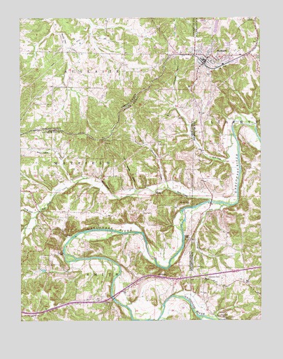
Richland, MO USGS Topographic Map
Click on map above to begin viewing in our Map Viewer.

This topographic map contains these locations and features:
Feature Name Type Latitude Longitude GNIS ID View Map
Armistead DamDamN37.8384°W92.4018°765449View Map
Barlow CreekStreamN37.7975°W92.3902°748671View Map
Bear CreekStreamN37.7989°W92.4007°748733View Map
Cave Spring HollowValleyN37.8045°W92.4416°749271View Map
Cedar Grove School (historical)SchoolN37.8078°W92.3841°753820View Map
City of RichlandCivilN37.8610°W92.3993°2396365View Map
Cliff SpringSpringN37.7850°W92.4760°715978View Map
ColensoLocaleN37.7587°W92.4674°740543View Map
Colenso Post OfficePost OfficeN37.7587°W92.4674°759993View Map
Cottonwood BranchStreamN37.8373°W92.4199°749491View Map
Cottonwood CreekStreamN37.8045°W92.4241°749492View Map
Davis CreekStreamN37.8067°W92.4721°749579View Map
Davis SchoolSchoolN37.7939°W92.4546°746807View Map
Dowty CemeteryCemeteryN37.7950°W92.4371°749694View Map
Duck CreekStreamN37.8262°W92.3891°749741View Map
Eaton School (historical)SchoolN37.8464°W92.4918°753904View Map
Eden Roadside ParkParkN37.7570°W92.4563°753320View Map
Eureka ChurchChurchN37.8231°W92.4293°749857View Map
GarnseyPopulated PlaceN37.8237°W92.4571°750024View Map
GascozarkPopulated PlaceN37.7675°W92.4041°753822View Map
Gascozark Hereford RanchLocaleN37.7531°W92.3916°753823View Map
Gascozark Hills ResortLocaleN37.7520°W92.3974°750030View Map
Gillming Lake DamDamN37.7700°W92.4885°765447View Map
HazelgreenPopulated PlaceN37.7675°W92.4274°750272View Map
Hazelgreen Fire Protection District Station 1 HeadquartersBuildingN37.7675°W92.4120°2621447View Map
Hazelgreen Fire Protection District Station 2BuildingN37.7761°W92.4972°2621297View Map
Hazelgreen Fire Protection District Station 3BuildingN37.7761°W92.4972°2620689View Map
Hillhouse AdditionPopulated PlaceN37.8603°W92.4196°758569View Map
Independence ChurchChurchN37.7675°W92.4029°750447View Map
Independence SchoolLocaleN37.7720°W92.3943°753319View Map
Laclede County CampLocaleN37.7787°W92.4807°750640View Map
Lake ArmisteadReservoirN37.8397°W92.4022°765450View Map
Manes CemeteryCemeteryN37.8739°W92.3816°750915View Map
Moore Lake DamDamN37.8634°W92.4302°765451View Map
Mount Satchel School (historical)SchoolN37.8192°W92.4177°746806View Map
Oaklawn CemeteryCemeteryN37.8520°W92.4024°751402View Map
Osage Fork Gasconade RiverStreamN37.7506°W92.4421°751448View Map
Pleasant Knoll School (historical)SchoolN37.8656°W92.4538°753905View Map
Rainey Lake DamDamN37.8234°W92.4752°765446View Map
RichlandPopulated PlaceN37.8570°W92.4043°751867View Map
Richland Police DepartmentBuildingN37.8582°W92.4051°2752575View Map
Richland Post OfficePost OfficeN37.8571°W92.4048°2783163View Map
Riverside LodgeLocaleN37.7837°W92.4143°751897View Map
Sandy CreekStreamN37.7953°W92.4907°752031View Map
Township of May/SmithCivilN37.7728°W92.4783°2397834View Map
Township of Mayfield (historical)CivilN37.8000°W92.4796°766863View Map
Township of Smith (historical)CivilN37.7528°W92.4793°766866View Map
Tri - County Fire and Rescue Association Station 1BuildingN37.8596°W92.3853°2620803View Map
Tri - County Fire Protection DistrictBuildingN37.8584°W92.4036°2620769View Map
Vancak Lake DamDamN37.7600°W92.4635°765448View Map
Wair ChapelChurchN37.8025°W92.4304°752727View Map
Wair SchoolSchoolN37.7562°W92.4771°753321View Map
Wildwood ResortLocaleN37.7984°W92.4132°752901View Map
Wilson HollowValleyN37.8192°W92.4824°752928View Map

Note: Coordinates in the location and feature list above are referenced to NAD83 datum.


Copyright (C) 2008-2024 Ryan Niemi / Sunset Dynamics ... All Rights Reserved