TopoQuest Logo
Do you find TopoQuest useful?
Help keep TopoQuest running and adding new maps/features by donating!
Bitcoin:  19c7KJd3qBynnjoSw5npx9KScwjBe4ifkT
Litecoin:  LXs6TkuXGGXo1vDsWCkWVdjQX94eUKd6ui
Home View Maps Find Maps Find Places Resources & Links


Richwoods, Missouri Topographic Map

USGS Map Title: Richwoods, MO
USGS Map MRC: 38090B7
DRG (GeoTIFF) Download: o38090b7.tif


Neighboring USGS Topographic Map Quads:


  Saint Clair, MO  
38090C8
 

  Lonedell, MO  
38090C7
 

  Cedar Hill, MO  
38090C6
 

  Cyclone Hollow, MO  
38090B8
 

  Richwoods, MO  
38090B7
 

  Fletcher, MO  
38090B6
 

  Ebo, MO  
38090A8
 

  Old Mines, MO  
38090A7
 

  Tiff, MO  
38090A6


Map MRC Location:

N39°
W91°
N39°
W90°
H8 H7 H6 H5 H4 H3 H2 H1
G8 G7 G6 G5 G4 G3 G2 G1
F8 F7 F6 F5 F4 F3 F2 F1
E8 E7 E6 E5 E4 E3 E2 E1
D8 D7 D6 D5 D4 D3 D2 D1
C8 C7 C6 C5 C4 C3 C2 C1
B8 B7 B6 B5 B4 B3 B2 B1
A8 A7 A6 A5 A4 A3 A2 A1
N38°
W91°
N38°
W90°

Richwoods, MO USGS 1:24K Topographic Map Preview:
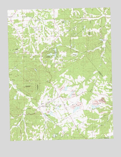
Richwoods, MO USGS Topographic Map
Click on map above to begin viewing in our Map Viewer.

This topographic map contains these locations and features:
Feature Name Type Latitude Longitude GNIS ID View Map
Alpine Lake DamDamN38.2317°W90.7818°764833View Map
Asplin CemeteryCemeteryN38.1828°W90.8715°741929View Map
Assaf Lake DamDamN38.1684°W90.8651°764832View Map
Berry BranchStreamN38.1439°W90.8293°738070View Map
Berry HillSummitN38.1253°W90.8157°738067View Map
Berry SchoolSchoolN38.1267°W90.8276°714000View Map
Big Four Mine DamDamN38.1551°W90.7701°764570View Map
Board Lead DiggingsMineN38.1348°W90.8104°736692View Map
Calico SchoolSchoolN38.1367°W90.7682°715199View Map
Click Lake DamDamN38.1917°W90.8418°764521View Map
Cool Valley Lake DamDamN38.2151°W90.8101°764381View Map
Cordia BranchStreamN38.1459°W90.8590°738065View Map
Davis Lake DamDamN38.1984°W90.8285°764831View Map
De Soto Rural Fire Protection District Station 6BuildingN38.2159°W90.7517°2620755View Map
Desoto Mining Comapny Pit and Plant A DamDamN38.1601°W90.7885°764281View Map
Desoto Mining Company Pit and Plant B DamDamN38.1751°W90.8051°764282View Map
Ditch Creek DamDamN38.1651°W90.7935°764567View Map
Edmonds and Wilcox Furnace and MillLocaleN38.1526°W90.8362°736691View Map
Elmwood ChurchChurchN38.2392°W90.8382°731567View Map
Elmwood School (historical)SchoolN38.2309°W90.8357°717557View Map
Emily CemeteryCemeteryN38.1556°W90.8529°741928View Map
Florendell DamDamN38.2117°W90.8178°764382View Map
French Lead DiggingsMineN38.1873°W90.8096°736690View Map
Hays HollowValleyN38.1403°W90.8654°738064View Map
HensleyPopulated PlaceN38.2434°W90.8710°730667View Map
Hillside View LakeReservoirN38.1494°W90.8329°738071View Map
Hoffman Lake DamDamN38.1717°W90.8268°765255View Map
Horine CemeteryCemeteryN38.1548°W90.8218°741926View Map
HurricanePopulated PlaceN38.1812°W90.8254°736688View Map
Indian Rock LakeReservoirN38.2064°W90.7931°758380View Map
Indian Rock Lake DamDamN38.2051°W90.7935°764870View Map
Indian SpringSpringN38.1412°W90.8575°738068View Map
Joan LakeReservoirN38.2092°W90.8665°738077View Map
Joan Lake Airport (historical)AirportN38.2084°W90.8668°758891View Map
Jones CemeteryCemeteryN38.2010°W90.7963°741931View Map
La Beaume Lead DiggingsMineN38.1667°W90.8271°736687View Map
Lake Aggravation DamDamN38.2074°W90.8179°764384View Map
Lake TranquilReservoirN38.2194°W90.7617°738072View Map
Lake Tranquil DamDamN38.2184°W90.7601°764142View Map
Little Indian Creek DamDamN38.1517°W90.8318°764558View Map
Lonedell LakeReservoirN38.2066°W90.8242°765179View Map
Lonedell Lake DamDamN38.2068°W90.8223°765178View Map
Lonedell LakesReservoirN38.2103°W90.8178°738076View Map
Lost Valley Lake West DamDamN38.2267°W90.7918°765496View Map
Lost Valley LakesReservoirN38.2314°W90.7821°738074View Map
MaupinPopulated PlaceN38.2406°W90.7840°738073View Map
McMullin SchoolSchoolN38.1464°W90.8049°722164View Map
Mononame 551 DamDamN38.1734°W90.8068°764552View Map
Mononame 558 DamDamN38.1284°W90.8201°764564View Map
Mononame 563 DamDamN38.1917°W90.8418°764571View Map
Mundy Lead DiggingsMineN38.1717°W90.7987°736686View Map
Old Ditch School (historical)SchoolN38.2098°W90.7540°737714View Map
Papoose CreekStreamN38.1573°W90.8426°736685View Map
Peppermint SpringsSpringN38.2373°W90.8065°738075View Map
Perkins East Lower Lake DamDamN38.2101°W90.7951°764383View Map
Perkins East Upper Lake DamDamN38.2167°W90.7951°765495View Map
Perkins West Lake DamDamN38.2151°W90.7985°765494View Map
Pierce LakeReservoirN38.1564°W90.8185°764830View Map
Pierce Lake DamDamN38.1567°W90.8201°764829View Map
Pinery CreekStreamN38.1632°W90.8481°724400View Map
Pinery School (historical)SchoolN38.1398°W90.8712°724401View Map
Providence ChurchChurchN38.1987°W90.8099°741930View Map
Providence SchoolSchoolN38.1984°W90.8093°724976View Map
RichwoodsPopulated PlaceN38.1603°W90.8282°725284View Map
Richwoods Fire Protection DistrictBuildingN38.1647°W90.8188°2620341View Map
Richwoods Lead MineMineN38.1589°W90.8185°736684View Map
Richwoods Mine B Mill DamDamN38.1751°W90.8085°765184View Map
Richwoods Pond DamDamN38.1684°W90.7951°764568View Map
Richwoods SchoolSchoolN38.1614°W90.8271°736683View Map
Saint Clair Fire Protection District Station 4BuildingN38.2464°W90.8668°2620785View Map
Saint Stephens Catholic ChurchChurchN38.1573°W90.8387°736693View Map
Saint Stephens CemeteryCemeteryN38.1589°W90.8365°741927View Map
Sixteenth Section Lead DiggingsMineN38.2006°W90.8057°736681View Map
Skewes Lead DiggingsMineN38.1531°W90.8360°736682View Map
Sparks CemeteryCemeteryN38.2301°W90.8374°741932View Map
Spring LakeReservoirN38.1317°W90.8201°764566View Map
Spring Lake DamDamN38.1317°W90.8201°764565View Map
Spring LakesReservoirN38.1291°W90.8216°738069View Map
Stieren Lake DamDamN38.2101°W90.8651°764835View Map
Taggett BranchStreamN38.1395°W90.7599°736680View Map
The Fraction Lead DiggingsMineN38.1742°W90.8118°736689View Map
Township of RichwoodsCivilN38.1370°W90.8514°767513View Map
Turkey Branch School (historical)SchoolN38.1709°W90.7768°727841View Map
Turkey CreekStreamN38.1878°W90.7696°727847View Map
Tyrey CreekStreamN38.2156°W90.7582°727944View Map

Note: Coordinates in the location and feature list above are referenced to NAD83 datum.


Copyright (C) 2008-2024 Ryan Niemi / Sunset Dynamics ... All Rights Reserved