TopoQuest Logo
Do you find TopoQuest useful?
Help keep TopoQuest running and adding new maps/features by donating!
Bitcoin:  19c7KJd3qBynnjoSw5npx9KScwjBe4ifkT
Litecoin:  LXs6TkuXGGXo1vDsWCkWVdjQX94eUKd6ui
Home View Maps Find Maps Find Places Resources & Links


Saint David, Illinois Topographic Map

USGS Map Title: Saint David, IL
USGS Map MRC: 40090D1
DRG (GeoTIFF) Download: o40090d1.tif


Neighboring USGS Topographic Map Quads:


  Fiatt, IL  
40090E2
 

  Canton, IL  
40090E1
 

  Banner, IL  
40089E8
 

  Lewistown, IL  
40090D2
 

  Saint David, IL  
40090D1
 

  Duck Island, IL  
40089D8
 

  Duncan Mills, IL  
40090C2
 

  Havana, IL  
40090C1
 

  Topeka, IL  
40089C8


Map MRC Location:

N41°
W91°
N41°
W90°
H8 H7 H6 H5 H4 H3 H2 H1
G8 G7 G6 G5 G4 G3 G2 G1
F8 F7 F6 F5 F4 F3 F2 F1
E8 E7 E6 E5 E4 E3 E2 E1
D8 D7 D6 D5 D4 D3 D2 D1
C8 C7 C6 C5 C4 C3 C2 C1
B8 B7 B6 B5 B4 B3 B2 B1
A8 A7 A6 A5 A4 A3 A2 A1
N40°
W91°
N40°
W90°

Saint David, IL USGS 1:24K Topographic Map Preview:
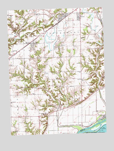
Saint David, IL USGS Topographic Map
Click on map above to begin viewing in our Map Viewer.

This topographic map contains these locations and features:
Feature Name Type Latitude Longitude GNIS ID View Map
Bethel Melthodist Episcopal Church (historical)ChurchN40.4148°W90.0929°1802195View Map
Bethel School (historical)SchoolN40.4153°W90.0926°404328View Map
Big Sister CreekStreamN40.3795°W90.0304°404435View Map
Blackaby School (historical)SchoolN40.4950°W90.1232°404507View Map
Bordner School (historical)SchoolN40.3787°W90.1179°404703View Map
BryantPopulated PlaceN40.4662°W90.0918°405072View Map
Bryant Post OfficePost OfficeN40.4663°W90.0964°2788601View Map
Bryant School (historical)SchoolN40.4659°W90.0918°1802185View Map
Buckheart County Fire DepartmentBuildingN40.3896°W90.0015°2640364View Map
Buckheart Township Fire Protection District Station 1BuildingN40.4918°W90.0494°2640302View Map
Buckheart Township Fire Protection District Station 2BuildingN40.4918°W90.0324°2640165View Map
Chautauqua National Wildlife RefugeParkN40.3757°W90.0011°422279View Map
Clark School (historical)SchoolN40.4042°W90.0587°406170View Map
Coal CreekStreamN40.4000°W90.0626°406283View Map
DunfermlinePopulated PlaceN40.4912°W90.0318°407496View Map
Dunfermline Post OfficePost OfficeN40.4902°W90.0318°2788190View Map
Dunfermline School (historical)SchoolN40.4875°W90.0321°1802193View Map
Elm Tree School (historical)SchoolN40.4367°W90.0310°407943View Map
Evelen BranchStreamN40.4720°W90.1115°408105View Map
Evelen LakeReservoirN40.4984°W90.1035°1692553View Map
Evelen Lake DamDamN40.4984°W90.1035°1692552View Map
Grass Lake (historical)LakeN40.3884°W90.0182°1802127View Map
Highbridge CemeteryCemeteryN40.4950°W90.0287°410210View Map
Keeler (historical)Populated PlaceN40.3973°W90.0648°1802129View Map
Little AmericaPopulated PlaceN40.4059°W90.0346°412276View Map
Little Sister CreekStreamN40.3884°W90.0640°412415View Map
Little Sister LakeReservoirN40.4584°W90.0568°1692551View Map
Little Sister Lake DamDamN40.4584°W90.0568°1692550View Map
Little Sister MineMineN40.4839°W90.0598°1802186View Map
Little Sister School (historical)SchoolN40.4625°W90.0560°412416View Map
LiverpoolPopulated PlaceN40.3917°W90.0009°412450View Map
Liverpool CemeteryCemeteryN40.3889°W90.0093°1773344View Map
Liverpool School (historical)SchoolN40.3912°W90.0034°1802192View Map
Locust Grove School (historical)SchoolN40.4698°W90.0296°412494View Map
Maples MillPopulated PlaceN40.4284°W90.0307°412971View Map
Maryville CemeteryCemeteryN40.4653°W90.0910°1773348View Map
Morning Star School (historical)SchoolN40.4587°W90.1196°413829View Map
Mount Pleasant CemeteryCemeteryN40.3970°W90.0788°1773350View Map
Mount Pleasant School (historical)SchoolN40.3962°W90.0785°414070View Map
Nazarene ChurchChurchN40.4448°W90.0310°414318View Map
New Hope School (historical)SchoolN40.4081°W90.1237°414435View Map
Oakland School (historical)SchoolN40.4298°W90.0004°414902View Map
Pleasant Row OrchardLocaleN40.4978°W90.0242°2556429View Map
Prichard School (historical)SchoolN40.4223°W90.0407°416214View Map
Rattlesnake BranchStreamN40.4267°W90.0840°424193View Map
Saint DavidPopulated PlaceN40.4934°W90.0487°417253View Map
Saint David City HallBuildingN40.4917°W90.0512°1802187View Map
Saint David Elementary SchoolSchoolN40.4925°W90.0498°1802194View Map
Saint David Methodist ChurchChurchN40.4925°W90.0485°1802190View Map
Saint David Nazarene ChurchChurchN40.4912°W90.0510°1802188View Map
Saint David Post OfficePost OfficeN40.4914°W90.0535°1802191View Map
Saint Michaels Roman Catholic ChurchChurchN40.4917°W90.0510°1802189View Map
Salem CemeteryCemeteryN40.4403°W90.0857°417859View Map
Salem School (historical)SchoolN40.4356°W90.0779°417885View Map
Science Hill School (historical)SchoolN40.4948°W90.0868°418126View Map
Slim Lake (historical)LakeN40.3967°W90.0282°1802128View Map
Sludge Pond Number 1-3AReservoirN40.4921°W90.1079°1692608View Map
Sludge Pond Number 1-3A Berm DamDamN40.4934°W90.1085°1692607View Map
Tampico MoundsSummitN40.4153°W90.0215°419534View Map
Township of BuckheartCivilN40.4952°W90.0482°428728View Map
Township of LiverpoolCivilN40.4159°W90.0320°429269View Map
Village of BryantCivilN40.4654°W90.0949°2397480View Map
Village of DunfermlineCivilN40.4914°W90.0321°2398755View Map
Village of LiverpoolCivilN40.3902°W90.0023°2398456View Map
Village of Saint DavidCivilN40.4920°W90.0520°2399161View Map
Wright CemeteryCemeteryN40.4446°W90.1235°1984237View Map
Wright ChurchChurchN40.4445°W90.1235°421526View Map

Note: Coordinates in the location and feature list above are referenced to NAD83 datum.


Copyright (C) 2008-2024 Ryan Niemi / Sunset Dynamics ... All Rights Reserved