TopoQuest Logo
Do you find TopoQuest useful?
Help keep TopoQuest running and adding new maps/features by donating!
Bitcoin:  19c7KJd3qBynnjoSw5npx9KScwjBe4ifkT
Litecoin:  LXs6TkuXGGXo1vDsWCkWVdjQX94eUKd6ui
Home View Maps Find Maps Find Places Resources & Links


South Haven, Minnesota Topographic Map

USGS Map Title: South Haven, MN
USGS Map MRC: 45094C2
DRG (GeoTIFF) Download: o45094c2.tif


Neighboring USGS Topographic Map Quads:


  Rockville, MN  
45094D3
 

  Saint Augusta, MN  
45094D2
 

  Clearwater, MN  
45094D1
 

  Kimball, MN  
45094C3
 

  South Haven, MN  
45094C2
 

  Annandale, MN  
45094C1
 

  Kingston, MN  
45094B3
 

  French Lake, MN  
45094B2
 

  Albion Center, MN  
45094B1


Map MRC Location:

N46°
W95°
N46°
W94°
H8 H7 H6 H5 H4 H3 H2 H1
G8 G7 G6 G5 G4 G3 G2 G1
F8 F7 F6 F5 F4 F3 F2 F1
E8 E7 E6 E5 E4 E3 E2 E1
D8 D7 D6 D5 D4 D3 D2 D1
C8 C7 C6 C5 C4 C3 C2 C1
B8 B7 B6 B5 B4 B3 B2 B1
A8 A7 A6 A5 A4 A3 A2 A1
N45°
W95°
N45°
W94°

South Haven, MN USGS 1:24K Topographic Map Preview:
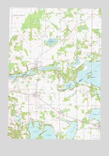
South Haven, MN USGS Topographic Map
Click on map above to begin viewing in our Map Viewer.

This topographic map contains these locations and features:
Feature Name Type Latitude Longitude GNIS ID View Map
Bungalow IslandIslandN45.3102°W94.1411°640643View Map
Camp HeritageLocaleN45.3175°W94.1808°640803View Map
City of South HavenCivilN45.2928°W94.2174°2395915View Map
Concordia CemeteryCemeteryN45.3185°W94.2141°641434View Map
Concordia Lutheran ChurchChurchN45.3208°W94.2139°2069180View Map
East Lake SylviaLakeN45.2534°W94.1931°652969View Map
Fair Haven Christian ChurchChurchN45.3208°W94.2139°2069181View Map
Fair Haven FarmLocaleN45.3244°W94.2181°2663727View Map
FairhavenPopulated PlaceN45.3216°W94.2114°643500View Map
Fairhaven CemeteryCemeteryN45.3223°W94.2063°2068097View Map
Fairhaven Census Designated PlaceCensusN45.3232°W94.2040°2628676View Map
Fairhaven Post Office (historical)Post OfficeN45.3217°W94.2111°2068290View Map
Goble LakeLakeN45.2675°W94.2382°644194View Map
Grace CemeteryCemeteryN45.2819°W94.1566°644291View Map
Koinonia Retreat ChurchChurchN45.2639°W94.1983°646227View Map
Lake AugustaLakeN45.3012°W94.1683°639519View Map
Lake CarolineLakeN45.3177°W94.1965°640922View Map
Lake JohnLakeN45.2596°W94.1641°645672View Map
Lake LouisaLakeN45.3089°W94.2442°647221View Map
Lake LuraLakeN45.3429°W94.1925°647305View Map
Lake MarieReservoirN45.3100°W94.2374°647532View Map
Little John LakeLakeN45.2713°W94.2373°646826View Map
Mead LakeLakeN45.2650°W94.2316°647710View Map
Otter LakeLakeN45.3238°W94.1577°649049View Map
Saint John's Lutheran ChurchChurchN45.2608°W94.1306°2067482View Map
Saint Johns CemeteryCemeteryN45.2613°W94.1419°650679View Map
South HavenLocaleN45.2908°W94.2150°2067470View Map
South HavenPopulated PlaceN45.2925°W94.2119°652314View Map
South Haven City HallBuildingN45.2914°W94.2142°2067472View Map
South Haven Fire DepartmentBuildingN45.2935°W94.2145°2067473View Map
South Haven Post OfficePost OfficeN45.2925°W94.2117°2067491View Map
Threemile CreekStreamN45.3252°W94.1469°653185View Map
Township of Fair HavenCivilN45.3579°W94.1917°664132View Map
Township of SouthsideCivilN45.2751°W94.2000°665656View Map
Union CemeteryCemeteryN45.2752°W94.1797°653497View Map
West Lake SylviaLakeN45.2519°W94.2144°653425View Map
Zion United Methodist ChurchChurchN45.2917°W94.2117°2067471View Map

Note: Coordinates in the location and feature list above are referenced to NAD83 datum.


Copyright (C) 2008-2024 Ryan Niemi / Sunset Dynamics ... All Rights Reserved