TopoQuest Logo
Do you find TopoQuest useful?
Help keep TopoQuest running and adding new maps/features by donating!
Bitcoin:  19c7KJd3qBynnjoSw5npx9KScwjBe4ifkT
Litecoin:  LXs6TkuXGGXo1vDsWCkWVdjQX94eUKd6ui
Home View Maps Find Maps Find Places Resources & Links


Coffman, Missouri Topographic Map

USGS Map Title: Coffman, MO
USGS Map MRC: 37090G2
DRG (GeoTIFF) Download: o37090g2.tif


Neighboring USGS Topographic Map Quads:


  Lawrenceton, MO  
37090H3
 

  Weingarten, MO  
37090H2
 

  Sainte Genevieve, MO  
37090H1
 

  Sprott, MO  
37090G3
 

  Coffman, MO  
37090G2
 

  Minnith, MO  
37090G1
 

  Knob Lick, MO  
37090F3
 

  Womack, MO  
37090F2
 

  Parker Lake, MO  
37090F1


Map MRC Location:

N38°
W91°
N38°
W90°
H8 H7 H6 H5 H4 H3 H2 H1
G8 G7 G6 G5 G4 G3 G2 G1
F8 F7 F6 F5 F4 F3 F2 F1
E8 E7 E6 E5 E4 E3 E2 E1
D8 D7 D6 D5 D4 D3 D2 D1
C8 C7 C6 C5 C4 C3 C2 C1
B8 B7 B6 B5 B4 B3 B2 B1
A8 A7 A6 A5 A4 A3 A2 A1
N37°
W91°
N37°
W90°

Coffman, MO USGS 1:24K Topographic Map Preview:
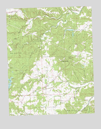
Coffman, MO USGS Topographic Map
Click on map above to begin viewing in our Map Viewer.

This topographic map contains these locations and features:
Feature Name Type Latitude Longitude GNIS ID View Map
AvonPopulated PlaceN37.7514°W90.2235°713512View Map
Avon Lead Mines (historical)MineN37.7559°W90.2046°737647View Map
Avon School (historical)SchoolN37.7514°W90.2201°737645View Map
Basler HollowValleyN37.7859°W90.1321°738152View Map
Beehive KnobSummitN37.8058°W90.2466°738146View Map
Big Spring HollowValleyN37.8067°W90.2226°738148View Map
Bloom CreekStreamN37.7806°W90.1540°714378View Map
Bluff CreekStreamN37.8667°W90.1651°738156View Map
Brands LakeReservoirN37.8077°W90.1371°764105View Map
Brands Lake Dam Section 22 SEDamN37.8084°W90.1351°764104View Map
Brands Lower Lake Section 22 DamDamN37.8034°W90.1401°764100View Map
Brands Upper Lake Section 22 DamDamN37.8051°W90.1418°764102View Map
Burns School (historical)SchoolN37.8423°W90.2260°736284View Map
Butterfly LakeReservoirN37.7921°W90.2490°715133View Map
Butterfly Lake DamDamN37.7884°W90.2468°764321View Map
Cheesebrough HillSummitN37.7934°W90.2065°738149View Map
Chimney RockSummitN37.8026°W90.2392°738147View Map
ClearwaterPopulated PlaceN37.7656°W90.1385°735962View Map
CoffmanPopulated PlaceN37.7845°W90.1943°716070View Map
Coffman Lookout TowerTowerN37.8153°W90.1607°742068View Map
Coffman SchoolSchoolN37.7778°W90.2123°742032View Map
Coffman Tower Site State Public Hunting AreaLocaleN37.8128°W90.1590°742035View Map
Coldwater CreekStreamN37.7606°W90.1334°749408View Map
Gordon School (historical)SchoolN37.8017°W90.2046°718616View Map
Haney CemeteryCemeteryN37.7637°W90.1737°742037View Map
Haney HillSummitN37.7685°W90.1518°738155View Map
Hawn State ParkParkN37.8217°W90.2362°737872View Map
Herzog HollowValleyN37.7826°W90.1376°738151View Map
Jackson CemeteryCemeteryN37.7724°W90.2331°742033View Map
Jonca CreekStreamN37.8698°W90.1532°720396View Map
La Hae SpringSpringN37.8392°W90.2401°738143View Map
Lake Kal-TatriReservoirN37.7951°W90.2418°764877View Map
Lake Kal-Tatri DamDamN37.7951°W90.2418°764876View Map
Laura Valley HillSummitN37.7744°W90.1524°738154View Map
Madden HillSummitN37.8052°W90.1547°738150View Map
Mayberry CemeteryCemeteryN37.7531°W90.2353°742034View Map
Mertell HillSummitN37.8633°W90.1302°737648View Map
Number 210 ReservoirReservoirN37.8039°W90.1402°764101View Map
Number 211 ReservoirReservoirN37.8058°W90.1421°764103View Map
Number 31 Dam (historical)DamN37.8451°W90.1535°763787View Map
Number 31 Lake (historical)ReservoirN37.8427°W90.1535°763788View Map
Number 32 Dam (historical)DamN37.8484°W90.1535°763789View Map
Number 32 Lake (historical)ReservoirN37.8480°W90.1565°763790View Map
Oakgrove SchoolSchoolN37.7592°W90.1826°736331View Map
Oakland School (historical)SchoolN37.7892°W90.1357°737646View Map
Pickle CreekStreamN37.8378°W90.2018°724312View Map
Pine Log CemeteryCemeteryN37.7581°W90.1832°2703054View Map
Pine Log ChurchChurchN37.7584°W90.1835°742038View Map
Rainbow LakeReservoirN37.7917°W90.2468°758386View Map
Rainbow Lake DamDamN37.7917°W90.2468°764482View Map
Rock SpringSpringN37.7887°W90.1951°737650View Map
Rock Spring School (historical)SchoolN37.7873°W90.1946°737651View Map
Roper HollowValleyN37.7859°W90.1282°738153View Map
Rough CreekStreamN37.8576°W90.2171°738177View Map
Smith School (historical)SchoolN37.8412°W90.1851°736351View Map
Stone Church CemeteryCemeteryN37.7739°W90.1701°742036View Map
Stone Methodist Church (historical)ChurchN37.7737°W90.1743°737653View Map
Township of SalineCivilN37.7642°W90.1960°767327View Map
Wild Hog BluffCliffN37.8287°W90.2043°738144View Map
Womack BranchStreamN37.8267°W90.2018°738145View Map

Note: Coordinates in the location and feature list above are referenced to NAD83 datum.


Copyright (C) 2008-2024 Ryan Niemi / Sunset Dynamics ... All Rights Reserved