TopoQuest Logo
Do you find TopoQuest useful?
Help keep TopoQuest running and adding new maps/features by donating!
Bitcoin:  19c7KJd3qBynnjoSw5npx9KScwjBe4ifkT
Litecoin:  LXs6TkuXGGXo1vDsWCkWVdjQX94eUKd6ui
Home View Maps Find Maps Find Places Resources & Links


Warner Springs, California Topographic Map

USGS Map Title: Warner Springs, CA
USGS Map MRC: 33116C6
DRG (GeoTIFF) Download: o33116c6.tif


Neighboring USGS Topographic Map Quads:


  Aguanga, CA  
33116D7
 

  Beauty Mountain, CA  
33116D6
 

  Bucksnort Mountain, CA  
33116D5
 

  Palomar Observatory, CA  
33116C7
 

  Warner Springs, CA  
33116C6
 

  Hot Springs Mountain, CA  
33116C5
 

  Mesa Grande, CA  
33116B7
 

  Warners Ranch, CA  
33116B6
 

  Ranchita, CA  
33116B5


Map MRC Location:

N34°
W117°
N34°
W116°
H8 H7 H6 H5 H4 H3 H2 H1
G8 G7 G6 G5 G4 G3 G2 G1
F8 F7 F6 F5 F4 F3 F2 F1
E8 E7 E6 E5 E4 E3 E2 E1
D8 D7 D6 D5 D4 D3 D2 D1
C8 C7 C6 C5 C4 C3 C2 C1
B8 B7 B6 B5 B4 B3 B2 B1
A8 A7 A6 A5 A4 A3 A2 A1
N33°
W117°
N33°
W116°

Warner Springs, CA USGS 1:24K Topographic Map Preview:
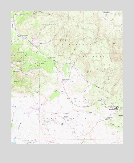
Warner Springs, CA USGS Topographic Map
Click on map above to begin viewing in our Map Viewer.

This topographic map contains these locations and features:
Feature Name Type Latitude Longitude GNIS ID View Map
Agua Caliente CreekStreamN33.2789°W116.7197°238441View Map
Bear CanyonValleyN33.3364°W116.7164°239076View Map
Big LakeLakeN33.2688°W116.6933°239289View Map
Blue CanyonValleyN33.3320°W116.7095°239491View Map
CAL FIRE Warner Springs Fire StationBuildingN33.2734°W116.6444°2664778View Map
Caņada Agua CalienteValleyN33.2875°W116.6545°240172View Map
Caņada AguangaValleyN33.3131°W116.6906°240173View Map
Caņada VerdeValleyN33.2814°W116.6600°240193View Map
Chamberlain RanchLocaleN33.3136°W116.6678°240461View Map
Chaney RanchLocaleN33.3075°W116.6578°240468View Map
Chimney LakeLakeN33.2790°W116.6647°240540View Map
Cow CanyonValleyN33.3336°W116.7122°241019View Map
Dark CanyonValleyN33.3459°W116.7295°241261View Map
Deadman HoleValleyN33.3403°W116.7194°241325View Map
Gunn CanyonValleyN33.3120°W116.6684°243088View Map
Holcomb VillagePopulated PlaceN33.3509°W116.7375°1660754View Map
Indian FlatsFlatN33.3492°W116.6617°243815View Map
Indian Flats CampgroundLocaleN33.3496°W116.6593°2548707View Map
Indian Flats Group CampgroundLocaleN33.3488°W116.6598°2548708View Map
Inspiration PointLocaleN33.2759°W116.6267°243867View Map
Johnson CanyonValleyN33.3634°W116.6406°244103View Map
Lake JeanLakeN33.3493°W116.7325°244016View Map
Lost LakeLakeN33.2705°W116.7012°245214View Map
Omaya RanchLocaleN33.3389°W116.6706°246900View Map
Pine MountainSummitN33.3450°W116.6575°247506View Map
Puerta La CruzLocaleN33.3109°W116.6934°247815View Map
Puerta La Cruz Conservation CampLocaleN33.3239°W116.6831°247816View Map
Puerta La Cruz Conservation CampLocaleN33.3311°W116.7078°247817View Map
Rock CanyonValleyN33.3328°W116.7081°248275View Map
Rocky MountainSummitN33.3517°W116.6861°1661324View Map
Saint Francis ChapelChurchN33.2859°W116.6367°1868503View Map
San Jose Del ValleCivilN33.2839°W116.6903°248872View Map
Sunshine Smmit Volunteer Fire DepartmentBuildingN33.3524°W116.7392°2664877View Map
Sunshine SummitGapN33.3517°W116.7386°250141View Map
Swan LakeLakeN33.2746°W116.6906°250167View Map
United States Navy Survival Training SchoolSchoolN33.2895°W116.6459°250812View Map
Ward CanyonValleyN33.2906°W116.6767°251166View Map
Warner Elementary SchoolSchoolN33.2742°W116.6428°251195View Map
Warner Hot SpringSpringN33.2842°W116.6313°251192View Map
Warner SpringsPopulated PlaceN33.2823°W116.6336°251194View Map
Warner Springs GliderportAirportN33.2845°W116.6756°1654102View Map
Warner Springs Post OfficePost OfficeN33.2835°W116.6348°2769523View Map
West Fork San Luis Rey RiverStreamN33.2667°W116.7439°251349View Map

Note: Coordinates in the location and feature list above are referenced to NAD83 datum.


Copyright (C) 2008-2024 Ryan Niemi / Sunset Dynamics ... All Rights Reserved