TopoQuest Logo
Do you find TopoQuest useful?
Help keep TopoQuest running and adding new maps/features by donating!
Bitcoin:  19c7KJd3qBynnjoSw5npx9KScwjBe4ifkT
Litecoin:  LXs6TkuXGGXo1vDsWCkWVdjQX94eUKd6ui
Home View Maps Find Maps Find Places Resources & Links


Whiteville, Louisiana Topographic Map

USGS Map Title: Whiteville, LA
USGS Map MRC: 30092G2
DRG (GeoTIFF) Download: o30092g2.tif


Neighboring USGS Topographic Map Quads:


  Lone Pine, LA  
30092H3
 

  Bunkie, LA  
30092H2
 

  Cottonport, LA  
30092H1
 

  Saint Landry, LA  
30092G3
 

  Whiteville, LA  
30092G2
 

  Morrow, LA  
30092G1
 

  Ville Platte, LA  
30092F3
 

  Tate Cove, LA  
30092F2
 

  Beggs, LA  
30092F1


Map MRC Location:

N31°
W93°
N31°
W92°
H8 H7 H6 H5 H4 H3 H2 H1
G8 G7 G6 G5 G4 G3 G2 G1
F8 F7 F6 F5 F4 F3 F2 F1
E8 E7 E6 E5 E4 E3 E2 E1
D8 D7 D6 D5 D4 D3 D2 D1
C8 C7 C6 C5 C4 C3 C2 C1
B8 B7 B6 B5 B4 B3 B2 B1
A8 A7 A6 A5 A4 A3 A2 A1
N30°
W93°
N30°
W92°

Whiteville, LA USGS 1:24K Topographic Map Preview:
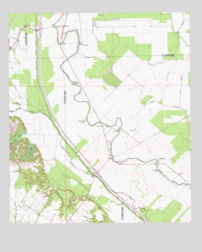
Whiteville, LA USGS Topographic Map
Click on map above to begin viewing in our Map Viewer.

This topographic map contains these locations and features:
Feature Name Type Latitude Longitude GNIS ID View Map
AugustaPopulated PlaceN30.8338°W92.2048°559803View Map
BarbreckPopulated PlaceN30.8102°W92.1987°559822View Map
Barbreck Post Office (historical)Post OfficeN30.8280°W92.2021°1631959View Map
Barbreck StationLocaleN30.8183°W92.1904°552569View Map
Bayou ChicotStreamN30.8185°W92.2426°532516View Map
Buller's Airstrip (historical)AirportN30.8087°W92.1880°2676746View Map
Cazan LakeSwampN30.8035°W92.2323°543864View Map
Chappel (historical)Populated PlaceN30.7974°W92.1604°552579View Map
Coulee TealStreamN30.7616°W92.1712°560497View Map
Fontenot CemeteryCemeteryN30.7613°W92.2410°535022View Map
Gold DustPopulated PlaceN30.8574°W92.1996°554542View Map
Indian LakeReservoirN30.7919°W92.2359°554827View Map
MilburnPopulated PlaceN30.8677°W92.2118°555313View Map
Mount Pilgrim ChurchChurchN30.7546°W92.2198°537379View Map
Mount Triumph ChurchChurchN30.8083°W92.1843°1627720View Map
Mount Zion ChurchChurchN30.7813°W92.1476°1627723View Map
Pilgrim ChurchChurchN30.8491°W92.1951°1627922View Map
Red BayouStreamN30.8180°W92.1312°1628028View Map
Saint Landry Parish Fire District 3 Station 9BuildingN30.7728°W92.1260°2691693View Map
Saint LouisPopulated PlaceN30.8055°W92.1746°1628132View Map
Ville Platte Oil and Gas FieldOilfieldN30.7544°W92.2418°540172View Map
Whites Chapel United Methodist ChurchChurchN30.7863°W92.1473°552698View Map
WhitevillePopulated PlaceN30.7883°W92.1476°1628499View Map
Whiteville AirportAirportN30.7853°W92.1811°1632999View Map
Whiteville Post OfficePost OfficeN30.7855°W92.1473°1632010View Map
Whiteville SchoolSchoolN30.7860°W92.1746°1628500View Map

Note: Coordinates in the location and feature list above are referenced to NAD83 datum.


Copyright (C) 2008-2024 Ryan Niemi / Sunset Dynamics ... All Rights Reserved