TopoQuest Logo
Do you find TopoQuest useful?
Help keep TopoQuest running and adding new maps/features by donating!
Bitcoin:  19c7KJd3qBynnjoSw5npx9KScwjBe4ifkT
Litecoin:  LXs6TkuXGGXo1vDsWCkWVdjQX94eUKd6ui
Home View Maps Find Maps Find Places Resources & Links


Bunkie, Louisiana Topographic Map

USGS Map Title: Bunkie, LA
USGS Map MRC: 30092H2
DRG (GeoTIFF) Download: o30092h2.tif


Neighboring USGS Topographic Map Quads:


  Cheneyville, LA  
31092A3
 

  Belle d'Eau, LA  
31092A2
 

  Marksville South, LA  
31092A1
 

  Lone Pine, LA  
30092H3
 

  Bunkie, LA  
30092H2
 

  Cottonport, LA  
30092H1
 

  Saint Landry, LA  
30092G3
 

  Whiteville, LA  
30092G2
 

  Morrow, LA  
30092G1


Map MRC Location:

N31°
W93°
N31°
W92°
H8 H7 H6 H5 H4 H3 H2 H1
G8 G7 G6 G5 G4 G3 G2 G1
F8 F7 F6 F5 F4 F3 F2 F1
E8 E7 E6 E5 E4 E3 E2 E1
D8 D7 D6 D5 D4 D3 D2 D1
C8 C7 C6 C5 C4 C3 C2 C1
B8 B7 B6 B5 B4 B3 B2 B1
A8 A7 A6 A5 A4 A3 A2 A1
N30°
W93°
N30°
W92°

Bunkie, LA USGS 1:24K Topographic Map Preview:
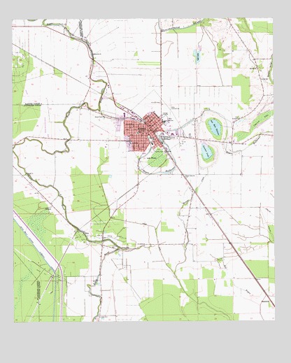
Bunkie, LA USGS Topographic Map
Click on map above to begin viewing in our Map Viewer.

This topographic map contains these locations and features:
Feature Name Type Latitude Longitude GNIS ID View Map
Abram Temple Church of GodChurchN30.9583°W92.1841°2601384View Map
Amazon Baptist ChurchChurchN30.9590°W92.1856°2600530View Map
Apostolic Lighthouse of BunkieChurchN30.9510°W92.1646°2600543View Map
Bay Hill ChurchChurchN30.9799°W92.1329°532362View Map
Bayou Boeuf - Cocodrie Diversion ChannelCanalN30.8999°W92.2348°532467View Map
Bayou Boeuf-Cocodrie Diversion ChannelCanalN30.8999°W92.2348°559879View Map
Bayou ClairStreamN30.8952°W92.1729°532528View Map
Bayou Rouge Oil FieldOilfieldN30.9291°W92.1368°545484View Map
Bennet Spur (historical)LocaleN30.9835°W92.2357°551816View Map
Booneville ChurchChurchN30.9860°W92.2121°533328View Map
BubenzerPopulated PlaceN30.9669°W92.2160°551823View Map
BunkiePopulated PlaceN30.9532°W92.1826°553834View Map
Bunkie Elementary SchoolSchoolN30.9489°W92.1836°545493View Map
Bunkie Fire DepartmentBuildingN30.9549°W92.1851°2672941View Map
Bunkie Flying ServiceAirportN30.9353°W92.1796°1632646View Map
Bunkie General HospitalHospitalN30.9530°W92.1763°2674106View Map
Bunkie High SchoolSchoolN30.9522°W92.1738°545494View Map
Bunkie Middle SchoolSchoolN30.9578°W92.1781°553913View Map
Bunkie Municipal AirportAirportN30.9525°W92.2334°545495View Map
Bunkie Oil FieldOilfieldN30.9688°W92.1537°545496View Map
Bunkie Police DepartmentBuildingN30.9578°W92.1872°2755240View Map
Bunkie Post OfficePost OfficeN30.9538°W92.1846°1630194View Map
CarbocoPopulated PlaceN30.9221°W92.2312°543056View Map
Cheneyville Oil and Gas FieldOilfieldN30.9830°W92.2454°553965View Map
Christian Baptist ChurchChurchN30.9588°W92.1871°2601482View Map
City of BunkieCivilN30.9540°W92.1884°2403952View Map
Cypress LakeLakeN30.9585°W92.1312°554172View Map
David Haas Memorial United Methodist ChurchChurchN30.9524°W92.1851°2601563View Map
DegeneresPopulated PlaceN30.8830°W92.1273°543136View Map
EolaPopulated PlaceN30.9113°W92.2160°543187View Map
Eola Oil and Gas FieldOilfieldN30.9110°W92.2057°554364View Map
Ewell Spur (historical)LocaleN30.9471°W92.1323°549402View Map
First Baptist ChurchChurchN30.9528°W92.1860°2601725View Map
First Union ChurchChurchN30.9355°W92.1671°554406View Map
Fogleman CemeteryCemeteryN30.9130°W92.2196°545513View Map
Friths (historical)Populated PlaceN30.9357°W92.1690°545516View Map
Haas Landing StripAirportN30.9571°W92.2343°545524View Map
Haas Oil and Gas FieldOilfieldN30.8935°W92.2301°535470View Map
Hatfield CemeteryCemeteryN30.9746°W92.1298°535560View Map
HolmesvillePopulated PlaceN30.9035°W92.1946°543309View Map
Kelley (historical)Populated PlaceN30.8860°W92.2023°557081View Map
Kingdom Hall of Jehovahs WitnessesChurchN30.9489°W92.1814°2602120View Map
Lac Bon GarçonLakeN30.9558°W92.1525°553749View Map
Lake WilsonLakeN30.9424°W92.1804°556456View Map
Lauther CemeteryCemeteryN30.8780°W92.2093°536359View Map
LeinsterPopulated PlaceN30.9580°W92.1429°545532View Map
Lyle LakeLakeN30.9843°W92.1611°555200View Map
Lyle Lake DamDamN30.9819°W92.1618°556898View Map
McDonald (historical)Populated PlaceN30.9388°W92.2443°545547View Map
Nibot (historical)Populated PlaceN30.8902°W92.1326°545588View Map
Parish Governing Authority District 13 (historical)CivilN30.8980°W92.1454°1929838View Map
Parish Governing Authority District 14 (historical)CivilN30.9227°W92.2279°1929850View Map
Parish Governing Authority District 6CivilN30.9939°W92.1452°1930120View Map
Parish Governing Authority District 8CivilN30.9058°W92.1578°1930225View Map
Pythian CemeteryCemeteryN30.9455°W92.1829°538446View Map
Rays Ferry (historical)LocaleN30.9504°W92.2241°2740663View Map
Saint Anthony of Padua SchoolSchoolN30.9528°W92.1901°555879View Map
Saint Joseph ChurchChurchN30.9066°W92.1873°538918View Map
Saint Joseph ChurchChurchN30.9371°W92.2443°538919View Map
Saint Pauls ChurchChurchN30.9591°W92.1415°539041View Map
Salem Baptist ChurchChurchN30.9568°W92.1804°2602779View Map
Second Union ChurchChurchN30.9599°W92.2054°539246View Map
Shirley (historical)Populated PlaceN30.9782°W92.2054°545578View Map
Star (historical)Populated PlaceN30.8946°W92.2035°545581View Map
Tanner LakeLakeN30.9450°W92.1576°556201View Map
Tanner Spur (historical)LocaleN30.9663°W92.2015°549420View Map
Tebow AirportAirportN30.9588°W92.1750°545583View Map
Trinity United Methodist ChurchChurchN30.9592°W92.1828°2602896View Map
Turner CanalCanalN30.9149°W92.1857°540043View Map
Ward TenCivilN30.9488°W92.1835°544919View Map

Note: Coordinates in the location and feature list above are referenced to NAD83 datum.


Copyright (C) 2008-2024 Ryan Niemi / Sunset Dynamics ... All Rights Reserved