TopoQuest Logo
Do you find TopoQuest useful?
Help keep TopoQuest running and adding new maps/features by donating!
Bitcoin:  19c7KJd3qBynnjoSw5npx9KScwjBe4ifkT
Litecoin:  LXs6TkuXGGXo1vDsWCkWVdjQX94eUKd6ui
Home View Maps Find Maps Find Places Resources & Links


Williamstown, Iowa Topographic Map

USGS Map Title: Williamstown, IA
USGS Map MRC: 41091E6
DRG (GeoTIFF) Download: o41091e6.tif


Neighboring USGS Topographic Map Quads:


  Oxford, IA  
41091F7
 

  Tiffin, IA  
41091F6
 

  Iowa City West, IA  
41091F5
 

  Amish, IA  
41091E7
 

  Williamstown, IA  
41091E6
 

  Hills, IA  
41091E5
 

  Wellman, IA  
41091D7
 

  Kalona, IA  
41091D6
 

  Riverside, IA  
41091D5


Map MRC Location:

N42°
W92°
N42°
W91°
H8 H7 H6 H5 H4 H3 H2 H1
G8 G7 G6 G5 G4 G3 G2 G1
F8 F7 F6 F5 F4 F3 F2 F1
E8 E7 E6 E5 E4 E3 E2 E1
D8 D7 D6 D5 D4 D3 D2 D1
C8 C7 C6 C5 C4 C3 C2 C1
B8 B7 B6 B5 B4 B3 B2 B1
A8 A7 A6 A5 A4 A3 A2 A1
N41°
W92°
N41°
W91°

Williamstown, IA USGS 1:24K Topographic Map Preview:
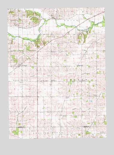
Williamstown, IA USGS Topographic Map
Click on map above to begin viewing in our Map Viewer.

This topographic map contains these locations and features:
Feature Name Type Latitude Longitude GNIS ID View Map
Belle AirLocaleN41.5122°W91.6457°466089View Map
Belle Air Post Office (historical)Post OfficeN41.5181°W91.6335°2002255View Map
Boone SchoolSchoolN41.5547°W91.6560°454756View Map
Eash CemeteryCemeteryN41.5799°W91.6521°465952View Map
East Lincoln SchoolSchoolN41.5556°W91.6952°456172View Map
East Union CemeteryCemeteryN41.5261°W91.7045°2002546View Map
East Union ChurchChurchN41.5256°W91.7054°456211View Map
Evergreen SchoolSchoolN41.5256°W91.6954°456443View Map
Fairview CemeteryCemeteryN41.5396°W91.6748°2002545View Map
Fairview ChurchChurchN41.5397°W91.6757°456509View Map
Frank Pierce Post Office (historical)Post OfficeN41.5708°W91.7335°2002256View Map
FrytownPopulated PlaceN41.5700°W91.7324°463065View Map
Frytown CemeteryCemeteryN41.5720°W91.7354°2002553View Map
Frytown Census Designated PlaceCensusN41.5719°W91.7321°2629964View Map
Gingerich CemeteryCemeteryN41.5076°W91.7223°456908View Map
Gingerich CemeteryCemeteryN41.5553°W91.7027°456909View Map
Graper CemeteryCemeteryN41.5917°W91.7224°2002554View Map
Grout CemeteryCemeteryN41.5402°W91.6367°2002543View Map
Hartsock SchoolSchoolN41.5833°W91.6946°465954View Map
Haven ChurchChurchN41.5547°W91.7327°457322View Map
Hochstetler CemeteryCemeteryN41.5528°W91.7418°2002547View Map
Hummer CemeteryCemeteryN41.5975°W91.6943°457724View Map
John Helmuth CemeteryCemeteryN41.5611°W91.6835°2002551View Map
Miller CemeteryCemeteryN41.5214°W91.6812°459100View Map
North Branch Old Mans CreekStreamN41.6133°W91.7013°459562View Map
Old Womans CreekStreamN41.6086°W91.6393°459846View Map
Pathway Christian SchoolSchoolN41.5152°W91.7128°1981712View Map
Peter Miller CemeteryCemeteryN41.5278°W91.6613°2002544View Map
Redbird Farms Wildlife AreaParkN41.6167°W91.7154°2002285View Map
Saint Johns ChurchChurchN41.5545°W91.6679°461043View Map
Saint Johns German Lutheran CemeteryCemeteryN41.5542°W91.6682°2002548View Map
Saint Peters CemeteryCemeteryN41.6092°W91.7410°461318View Map
Sharon Bethel ChurchChurchN41.5553°W91.7088°461530View Map
Sharon CenterPopulated PlaceN41.5692°W91.6613°461533View Map
Sharon Center Post Office (historical)Post OfficeN41.5692°W91.6613°2002257View Map
Sharon ChurchChurchN41.5406°W91.6371°461538View Map
Sharon ChurchChurchN41.5547°W91.6552°461539View Map
Sharon United CemeteryCemeteryN41.5542°W91.6558°2002549View Map
Snider CemeteryCemeteryN41.5001°W91.7191°1981814View Map
Township of SharonCivilN41.5552°W91.6558°468686View Map
Unity CemeteryCemeteryN41.6195°W91.6474°2002539View Map
Willow Grove SchoolSchoolN41.5842°W91.6502°463092View Map
Yoder CemeteryCemeteryN41.5667°W91.6460°2002550View Map
Yoder CemeteryCemeteryN41.5639°W91.7224°2002552View Map

Note: Coordinates in the location and feature list above are referenced to NAD83 datum.


Copyright (C) 2008-2024 Ryan Niemi / Sunset Dynamics ... All Rights Reserved