TopoQuest Logo
Do you find TopoQuest useful?
Help keep TopoQuest running and adding new maps/features by donating!
Bitcoin:  19c7KJd3qBynnjoSw5npx9KScwjBe4ifkT
Litecoin:  LXs6TkuXGGXo1vDsWCkWVdjQX94eUKd6ui
Home View Maps Find Maps Find Places Resources & Links


Brownton, West Virginia Topographic Map

USGS Map Title: Brownton, WV
USGS Map MRC: 39080B2
DRG (GeoTIFF) Download: o39080b2.tif


Neighboring USGS Topographic Map Quads:


  Clarksburg, WV  
39080C3
 

  Rosemont, WV  
39080C2
 

  Grafton, WV  
39080C1
 

  Mount Clare, WV  
39080B3
 

  Brownton, WV  
39080B2
 

  Philippi, WV  
39080B1
 

  Berlin, WV  
39080A3
 

  Century, WV  
39080A2
 

  Audra, WV  
39080A1


Map MRC Location:

N40°
W81°
N40°
W80°
H8 H7 H6 H5 H4 H3 H2 H1
G8 G7 G6 G5 G4 G3 G2 G1
F8 F7 F6 F5 F4 F3 F2 F1
E8 E7 E6 E5 E4 E3 E2 E1
D8 D7 D6 D5 D4 D3 D2 D1
C8 C7 C6 C5 C4 C3 C2 C1
B8 B7 B6 B5 B4 B3 B2 B1
A8 A7 A6 A5 A4 A3 A2 A1
N39°
W81°
N39°
W80°

Brownton, WV USGS 1:24K Topographic Map Preview:
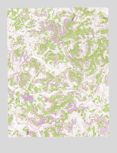
Brownton, WV USGS Topographic Map
Click on map above to begin viewing in our Map Viewer.

This topographic map contains these locations and features:
Feature Name Type Latitude Longitude GNIS ID View Map
Arnold RunStreamN39.1659°W80.2165°1535024View Map
AstorPopulated PlaceN39.2404°W80.1412°1553761View Map
Astor CemeteryCemeteryN39.2418°W80.1454°1689877View Map
Astor United Methodist ChurchChurchN39.2406°W80.1426°1689879View Map
Bamgardner School (historical)SchoolN39.1873°W80.2426°1718430View Map
Bartlett RunStreamN39.2376°W80.1401°1535287View Map
Bean CemeteryCemeteryN39.1369°W80.1939°2586258View Map
Bear MountainPopulated PlaceN39.2173°W80.1668°1535379View Map
Beech LickStreamN39.1537°W80.1392°1535542View Map
Birds RunStreamN39.1718°W80.2256°1536041View Map
Birds Run School (historical)SchoolN39.1806°W80.2184°1718433View Map
BrowntonPopulated PlaceN39.2201°W80.1501°1553996View Map
Brownton Census Designated PlaceCensusN39.2224°W80.1530°2586772View Map
Brushy Fork School (historical)SchoolN39.1854°W80.1434°1697020View Map
Brushy Fork School (historical)SchoolN39.1915°W80.1687°1536513View Map
Chrislip CemeteryCemeteryN39.1886°W80.1575°2724522View Map
Coplin RunStreamN39.2234°W80.2312°1537672View Map
Ebenezer ChurchChurchN39.1584°W80.1442°1697052View Map
Ebenezer School (historical)SchoolN39.1590°W80.1445°1538537View Map
Galloway Census Designated PlaceCensusN39.2339°W80.1277°2586808View Map
Glade RunStreamN39.2156°W80.2240°1539432View Map
Goodwin School (historical)SchoolN39.2473°W80.1918°1718455View Map
Green Hill CemeteryCemeteryN39.1670°W80.2204°1697071View Map
Green Hill United Methodist ChurchChurchN39.1676°W80.2209°1539678View Map
Isaacs RunStreamN39.1570°W80.1454°1540732View Map
Lower Brushy Fork School (historical)SchoolN39.1915°W80.1890°1697112View Map
Mount Tabor CemeteryCemeteryN39.1876°W80.1329°1697132View Map
Mount Tabor ChurchChurchN39.1876°W80.1334°1543770View Map
Mount Vernon Baptist ChurchChurchN39.2209°W80.1434°1697133View Map
Mount Vernon Elementary SchoolSchoolN39.2209°W80.1418°1543793View Map
Mudlick School (historical)SchoolN39.2145°W80.2231°1718492View Map
Nutter CemeteryCemeteryN39.1681°W80.1487°1544256View Map
Nutters Place SpringSpringN39.1645°W80.1498°1677976View Map
Oreslip CemeteryCemeteryN39.1884°W80.1576°1544442View Map
OverfieldPopulated PlaceN39.1693°W80.2043°1544481View Map
Overfield Community ChurchChurchN39.1687°W80.2037°1697143View Map
Overfield School (historical)SchoolN39.1668°W80.2009°1697145View Map
PeeltreePopulated PlaceN39.1295°W80.2106°1544690View Map
Peeltree RunStreamN39.1334°W80.2415°1544692View Map
Peeltree Run School (historical)SchoolN39.1257°W80.2454°1718501View Map
PepperPopulated PlaceN39.1887°W80.1565°1555326View Map
Pigtail RunStreamN39.2487°W80.1929°1544846View Map
Pigtail School (historical)SchoolN39.2365°W80.1868°1718503View Map
Raccoon CreekStreamN39.1565°W80.2423°1545359View Map
Raccoon School (historical)SchoolN39.1584°W80.2395°1718507View Map
Rexroad Airport (historical)AirportN39.1357°W80.2104°1558786View Map
Stewart RunStreamN39.1526°W80.1365°1547408View Map
Stewart Run School (historical)SchoolN39.1801°W80.1312°1697182View Map
Stillhouse RunStreamN39.2212°W80.1406°1547419View Map
Stonecoal RunStreamN39.2015°W80.2095°1547475View Map
Trinity ChurchChurchN39.2259°W80.2409°1548270View Map
West Branch Simpson CreekStreamN39.2306°W80.1398°1548921View Map
West DistrictCivilN39.1466°W80.1274°1928406View Map

Note: Coordinates in the location and feature list above are referenced to NAD83 datum.


Copyright (C) 2008-2024 Ryan Niemi / Sunset Dynamics ... All Rights Reserved