TopoQuest Logo
Do you find TopoQuest useful?
Help keep TopoQuest running and adding new maps/features by donating!
Bitcoin:  19c7KJd3qBynnjoSw5npx9KScwjBe4ifkT
Litecoin:  LXs6TkuXGGXo1vDsWCkWVdjQX94eUKd6ui
Home View Maps Find Maps Find Places Resources & Links


Buena Vista, Tennessee Topographic Map

USGS Map Title: Buena Vista, TN
USGS Map MRC: 35088H3
DRG (GeoTIFF) Download: o35088h3.tif


Neighboring USGS Topographic Map Quads:


  Huntingdon, TN  
36088A4
 

  Vale, TN  
36088A3
 

  Bruceton, TN  
36088A2
 

  Palmer Shelter, TN  
35088H4
 

  Buena Vista, TN  
35088H3
 

  Seventeen Creek, TN  
35088H2
 

  Clarksburg, TN  
35088G4
 

  Yuma, TN  
35088G3
 

  Holladay, TN  
35088G2


Map MRC Location:

N36°
W89°
N36°
W88°
H8 H7 H6 H5 H4 H3 H2 H1
G8 G7 G6 G5 G4 G3 G2 G1
F8 F7 F6 F5 F4 F3 F2 F1
E8 E7 E6 E5 E4 E3 E2 E1
D8 D7 D6 D5 D4 D3 D2 D1
C8 C7 C6 C5 C4 C3 C2 C1
B8 B7 B6 B5 B4 B3 B2 B1
A8 A7 A6 A5 A4 A3 A2 A1
N35°
W89°
N35°
W88°

Buena Vista, TN USGS 1:24K Topographic Map Preview:
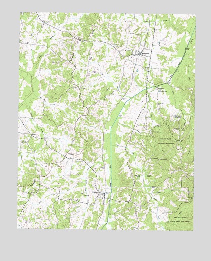
Buena Vista, TN USGS Topographic Map
Click on map above to begin viewing in our Map Viewer.

This topographic map contains these locations and features:
Feature Name Type Latitude Longitude GNIS ID View Map
Bacon CreekStreamN35.9176°W88.3092°1276068View Map
Bar Springs CemeteryCemeteryN35.9128°W88.3525°1326780View Map
Bateman BranchStreamN35.8959°W88.2817°1276450View Map
Beaver Creek ChurchChurchN35.9998°W88.3748°1326784View Map
Bell CreekStreamN35.9512°W88.2956°1305080View Map
Birdwell CemeteryCemeteryN35.9359°W88.2753°1277518View Map
Blunt CreekStreamN35.9603°W88.2689°1305322View Map
Bradford SwampSwampN35.9073°W88.2841°1278174View Map
Buck DitchStreamN35.9540°W88.3653°1278812View Map
Buena VistaPopulated PlaceN35.9765°W88.2895°1305502View Map
Buena Vista Post OfficePost OfficeN35.9760°W88.2900°1651402View Map
Buena Vista School (historical)SchoolN35.9784°W88.2914°1320311View Map
Carroll County Rural Fire Department District 19 WestportBuildingN35.8955°W88.3129°2654152View Map
Carroll County Rural Fire Department District 3 Buena VistaBuildingN35.9763°W88.2866°2653679View Map
Cawthon CemeteryCemeteryN35.9706°W88.3478°1279981View Map
Clarksburg Division (historical)CensusN35.8942°W88.3648°1648628View Map
Commissioner District 3CivilN35.9899°W88.3192°2464126View Map
Commissioner District 6CivilN35.8790°W88.3552°2464514View Map
ConcordPopulated PlaceN35.9292°W88.3659°1281060View Map
Concord Baptist ChurchChurchN35.9278°W88.3620°1645042View Map
Concord School (historical)SchoolN35.9290°W88.3664°1320321View Map
Cross RoadsPopulated PlaceN35.9167°W88.3417°1326734View Map
Crow BranchStreamN35.9387°W88.3056°1281737View Map
Dawson BranchStreamN35.9423°W88.2525°1282213View Map
District 11 (historical)CivilN35.9584°W88.3667°1325884View Map
District 15 (historical)CivilN35.9667°W88.2875°1325888View Map
District 24 (historical)CivilN35.8917°W88.3362°1325897View Map
DollarPopulated PlaceN35.9101°W88.2600°1326807View Map
Dry BranchStreamN35.9692°W88.3634°1282853View Map
Eli BranchStreamN35.9759°W88.2581°1283624View Map
Eubank CemeteryCemeteryN35.9193°W88.3011°2576240View Map
GarrettsburgPopulated PlaceN35.9565°W88.2764°1315100View Map
Goose Pond SwampSwampN35.9058°W88.2888°1285687View Map
Haines BranchStreamN35.9587°W88.3103°1286502View Map
Hall School (historical)SchoolN35.8890°W88.2859°1320326View Map
Hawkins CreekStreamN35.9492°W88.3703°1287187View Map
Humble BranchStreamN35.9631°W88.3662°1288694View Map
Humbles CemeteryCemeteryN35.9931°W88.3567°1646036View Map
Humbles Chapel Baptist ChurchChurchN35.9948°W88.3581°1306594View Map
Indian CreekStreamN35.9567°W88.2839°1288945View Map
Jamison CemeteryCemeteryN35.9148°W88.3303°1289289View Map
Jones Store (historical)LocaleN35.8934°W88.2509°1320341View Map
Little Bacon CreekStreamN35.9076°W88.3262°1291368View Map
Louder School (historical)SchoolN35.8853°W88.3481°1320343View Map
Lyle BranchStreamN35.9892°W88.2520°1292322View Map
Maple CreekStreamN35.9240°W88.3089°1292617View Map
McCallie CemeteryCemeteryN35.9823°W88.3092°1293108View Map
Moore CreekStreamN35.9887°W88.2525°1294287View Map
Mount Nebo Baptist ChurchChurchN35.9767°W88.2912°1646048View Map
Mount ZionPopulated PlaceN35.9998°W88.3745°1326670View Map
Mud Creek Primitive Baptist ChurchChurchN35.9251°W88.3689°1326838View Map
Oak Grove Baptist ChurchChurchN35.9340°W88.2606°1306846View Map
Oak Grove CemeteryCemeteryN35.9348°W88.2609°1646049View Map
Pond BranchStreamN35.9867°W88.2531°1298089View Map
Ray CemeteryCemeteryN35.9931°W88.3225°1298992View Map
Robinson SwampSwampN35.9001°W88.2820°1299718View Map
Smith CemeteryCemeteryN35.8945°W88.3662°1270614View Map
SmyrnaPopulated PlaceN35.9565°W88.3317°1270734View Map
Smyrna Church (historical)ChurchN35.9484°W88.3323°1320369View Map
Smyrna School (historical)SchoolN35.9567°W88.3317°1320370View Map
Spanish GrovePopulated PlaceN35.9323°W88.2812°1326681View Map
Spanish Grove Community CenterLocaleN35.9323°W88.2806°1270945View Map
Spanish Grove School (historical)SchoolN35.9323°W88.2806°1320371View Map
Spellings CemeteryCemeteryN35.9792°W88.2953°1270978View Map
Sunshine LakeReservoirN35.9557°W88.2749°1271888View Map
Taylor CemeteryCemeteryN35.9401°W88.2848°1272207View Map
Thomas BranchStreamN35.8792°W88.2731°1272464View Map
Tucker CemeteryCemeteryN35.8942°W88.3284°1272947View Map
WestportPopulated PlaceN35.8965°W88.3173°1304495View Map
Westport Post OfficePost OfficeN35.8960°W88.3134°1651429View Map
Westport School (historical)SchoolN35.9003°W88.3200°1320382View Map
Williams ChapelPopulated PlaceN35.8962°W88.3609°1326684View Map
Williams ChapelChurchN35.8970°W88.3603°1304602View Map

Note: Coordinates in the location and feature list above are referenced to NAD83 datum.


Copyright (C) 2008-2024 Ryan Niemi / Sunset Dynamics ... All Rights Reserved