TopoQuest Logo
Do you find TopoQuest useful?
Help keep TopoQuest running and adding new maps/features by donating!
Bitcoin:  19c7KJd3qBynnjoSw5npx9KScwjBe4ifkT
Litecoin:  LXs6TkuXGGXo1vDsWCkWVdjQX94eUKd6ui
Home View Maps Find Maps Find Places Resources & Links


Palmer Shelter, Tennessee Topographic Map

USGS Map Title: Palmer Shelter, TN
USGS Map MRC: 35088H4
DRG (GeoTIFF) Download: o35088h4.tif


Neighboring USGS Topographic Map Quads:


  Trezevant East, TN  
36088A5
 

  Huntingdon, TN  
36088A4
 

  Vale, TN  
36088A3
 

  McLemoresville, TN  
35088H5
 

  Palmer Shelter, TN  
35088H4
 

  Buena Vista, TN  
35088H3
 

  Cedar Grove, TN  
35088G5
 

  Clarksburg, TN  
35088G4
 

  Yuma, TN  
35088G3


Map MRC Location:

N36°
W89°
N36°
W88°
H8 H7 H6 H5 H4 H3 H2 H1
G8 G7 G6 G5 G4 G3 G2 G1
F8 F7 F6 F5 F4 F3 F2 F1
E8 E7 E6 E5 E4 E3 E2 E1
D8 D7 D6 D5 D4 D3 D2 D1
C8 C7 C6 C5 C4 C3 C2 C1
B8 B7 B6 B5 B4 B3 B2 B1
A8 A7 A6 A5 A4 A3 A2 A1
N35°
W89°
N35°
W88°

Palmer Shelter, TN USGS 1:24K Topographic Map Preview:
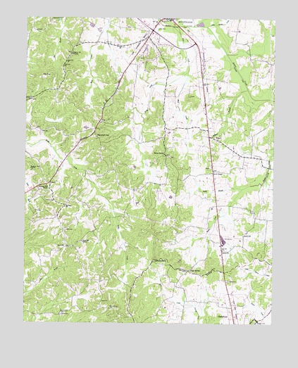
Palmer Shelter, TN USGS Topographic Map
Click on map above to begin viewing in our Map Viewer.

This topographic map contains these locations and features:
Feature Name Type Latitude Longitude GNIS ID View Map
AnarkPopulated PlaceN35.9048°W88.4009°1647520View Map
Anark ChurchChurchN35.9048°W88.4003°1304826View Map
Anark SchoolSchoolN35.9112°W88.3900°1275673View Map
Antioch CemeteryCemeteryN35.9251°W88.4853°1275788View Map
Black CemeteryCemeteryN35.8837°W88.4612°1277551View Map
Blair CemeteryCemeteryN35.8756°W88.3817°1305278View Map
Brier CreekStreamN35.9967°W88.4237°1278365View Map
Butler BranchStreamN35.9301°W88.3903°1279170View Map
Carroll CountyCivilN35.9732°W88.4503°1639729View Map
Carroll County Rural Fire Department District 1 HuntingdonBuildingN35.9888°W88.4262°2654271View Map
Commissioner District 7CivilN35.9851°W88.4792°2464593View Map
Davis ChapelPopulated PlaceN35.9365°W88.4056°1326895View Map
Davis ChapelChurchN35.9373°W88.4048°1306282View Map
Davis Chapel CemeteryCemeteryN35.9378°W88.4053°1326657View Map
District 12 (historical)CivilN35.9501°W88.4084°1325885View Map
Ernest Vickers DamDamN35.9967°W88.4667°1302279View Map
Ernest Vickers LakeReservoirN35.9970°W88.4673°1302278View Map
Giles CemeteryCemeteryN35.9537°W88.4920°1285383View Map
HillardPopulated PlaceN35.9517°W88.4075°1287811View Map
Hillard BranchStreamN35.9709°W88.3884°1287812View Map
Hillard School (historical)SchoolN35.9506°W88.4053°1320329View Map
Huntingdon AirportAirportN35.9929°W88.4624°1301385View Map
Huntingdon First Baptist ChurchChurchN35.9998°W88.4287°1320337View Map
LakewoodPopulated PlaceN35.9995°W88.4876°1315347View Map
LeachPopulated PlaceN35.9328°W88.4873°1290854View Map
Liberty All CemeteryCemeteryN35.9848°W88.4770°1646037View Map
Liberty All ChurchChurchN35.9853°W88.4770°1306682View Map
Liberty Baptist ChurchChurchN35.8784°W88.4823°1326825View Map
Liberty CemeteryCemeteryN35.8781°W88.4820°1326666View Map
Little Beaver CreekStreamN35.9856°W88.3992°1275402View Map
Marshall HillSummitN35.9512°W88.4639°1292768View Map
Mud CreekStreamN35.9781°W88.4184°1294994View Map
Northwood BranchStreamN35.9965°W88.4092°1275406View Map
Palmer ShelterCemeteryN35.9431°W88.4273°1326675View Map
Palmer ShelterLocaleN35.9442°W88.4298°1296700View Map
Palmer Shelter United Methodist ChurchChurchN35.9428°W88.4284°1326886View Map
Pleasant Hill CemeteryCemeteryN35.9373°W88.4973°1326678View Map
Pleasant Hill ChurchChurchN35.9373°W88.4967°1297872View Map
Pleasant Hill SchoolSchoolN35.9315°W88.4889°1297897View Map
Poplar SpringsPopulated PlaceN35.8967°W88.4173°1315762View Map
Poplar Springs Church of ChristChurchN35.8967°W88.4170°1646052View Map
Poplar Springs School (historical)SchoolN35.8967°W88.4175°1320361View Map
Scott HillPopulated PlaceN35.9059°W88.4806°1315882View Map
Scott Hill SchoolSchoolN35.9087°W88.4714°1300955View Map
Sellers CemeteryCemeteryN35.8923°W88.3970°1326859View Map
Slip TopSummitN35.9762°W88.4920°1270526View Map
TatePopulated PlaceN35.9573°W88.4631°1272143View Map
Tate School (historical)SchoolN35.9570°W88.4623°1320375View Map
WPBE-FM (Huntingdon)TowerN35.9515°W88.4631°1640077View Map

Note: Coordinates in the location and feature list above are referenced to NAD83 datum.


Copyright (C) 2008-2024 Ryan Niemi / Sunset Dynamics ... All Rights Reserved