TopoQuest Logo
Do you find TopoQuest useful?
Help keep TopoQuest running and adding new maps/features by donating!
Bitcoin:  19c7KJd3qBynnjoSw5npx9KScwjBe4ifkT
Litecoin:  LXs6TkuXGGXo1vDsWCkWVdjQX94eUKd6ui
Home View Maps Find Maps Find Places Resources & Links


Huntingdon, Tennessee Topographic Map

USGS Map Title: Huntingdon, TN
USGS Map MRC: 36088A4
DRG (GeoTIFF) Download: o36088a4.tif


Neighboring USGS Topographic Map Quads:


  McKenzie, TN  
36088B5
 

  Henry, TN  
36088B4
 

  Mansfield, TN  
36088B3
 

  Trezevant East, TN  
36088A5
 

  Huntingdon, TN  
36088A4
 

  Vale, TN  
36088A3
 

  McLemoresville, TN  
35088H5
 

  Palmer Shelter, TN  
35088H4
 

  Buena Vista, TN  
35088H3


Map MRC Location:

N37°
W89°
N37°
W88°
H8 H7 H6 H5 H4 H3 H2 H1
G8 G7 G6 G5 G4 G3 G2 G1
F8 F7 F6 F5 F4 F3 F2 F1
E8 E7 E6 E5 E4 E3 E2 E1
D8 D7 D6 D5 D4 D3 D2 D1
C8 C7 C6 C5 C4 C3 C2 C1
B8 B7 B6 B5 B4 B3 B2 B1
A8 A7 A6 A5 A4 A3 A2 A1
N36°
W89°
N36°
W88°

Huntingdon, TN USGS 1:24K Topographic Map Preview:
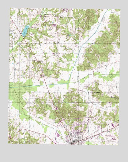
Huntingdon, TN USGS Topographic Map
Click on map above to begin viewing in our Map Viewer.

This topographic map contains these locations and features:
Feature Name Type Latitude Longitude GNIS ID View Map
Allen CemeteryCemeteryN36.0048°W88.3931°1320299View Map
Baptist Memorial Hospital HuntingtonHospitalN36.0234°W88.4124°1320302View Map
Beaver Academy (historical)SchoolN36.0012°W88.3756°1320304View Map
Bee BranchStreamN36.0234°W88.4734°1276765View Map
BethelPopulated PlaceN36.0356°W88.4487°1277097View Map
Bethel Baptist ChurchChurchN36.0370°W88.4481°1320307View Map
Bethel CemeteryCemeteryN36.0370°W88.4478°1646030View Map
Brier CreekStreamN36.0584°W88.4214°1278366View Map
Burrow CreekStreamN36.0892°W88.4189°1279122View Map
Carroll County AirportAirportN36.0867°W88.4659°2675487View Map
Carroll County CourthouseBuildingN36.0006°W88.4281°1320314View Map
Carroll County Sheriff's OfficeBuildingN36.0020°W88.4289°2765800View Map
Carroll County Vocational CenterSchoolN36.0056°W88.3845°1320316View Map
Carroll LakeReservoirN36.1037°W88.4823°1305705View Map
Carroll Lake DamDamN36.1001°W88.4853°1307187View Map
Carroll Rural Volunteer FireBuildingN36.0232°W88.4106°2653724View Map
Carter CemeteryCemeteryN36.0445°W88.4364°1279796View Map
Clark CemeteryCemeteryN36.0067°W88.4281°1280597View Map
Commissioner District 5CivilN36.0234°W88.3885°2464425View Map
Commissioner District 9CivilN36.1039°W88.4761°2464711View Map
District 25 (historical)CivilN36.0334°W88.4417°1325898View Map
District 4 (historical)CivilN36.1084°W88.4667°1325877View Map
District 9 (historical)CivilN36.1126°W88.4334°1325882View Map
Edwards ParkParkN36.0067°W88.4253°1283562View Map
FairviewPopulated PlaceN36.0770°W88.4681°1647521View Map
Fairview Baptist ChurchChurchN36.0762°W88.4642°1284020View Map
Fairview CemeteryCemeteryN36.0764°W88.4637°1326661View Map
Finley CemeteryCemeteryN36.0762°W88.4445°1284273View Map
Gordon CemeteryCemeteryN36.1201°W88.4267°1285697View Map
Guins CreekStreamN36.0565°W88.4337°1269277View Map
Hale SchoolSchoolN36.0101°W88.4278°1286523View Map
HicoPopulated PlaceN36.0912°W88.4895°1315233View Map
Hico School (historical)SchoolN36.0898°W88.4881°1320328View Map
Hico StationLocaleN36.0684°W88.4939°1287673View Map
HuntingdonPopulated PlaceN36.0006°W88.4281°1288761View Map
Huntingdon Division (historical)CensusN36.0081°W88.4226°1648629View Map
Huntingdon Elementary SchoolSchoolN36.0065°W88.4217°1320336View Map
Huntingdon Fire Department Station 1BuildingN36.0001°W88.4272°2653756View Map
Huntingdon Fire Department Station 2BuildingN36.0111°W88.4257°2653926View Map
Huntingdon Fire Department Station 2BuildingN36.0107°W88.4026°2653927View Map
Huntingdon High SchoolSchoolN36.0062°W88.3820°1320338View Map
Huntingdon Junior High SchoolSchoolN36.0070°W88.4223°1320339View Map
Huntingdon Plaza Shopping CenterLocaleN36.0059°W88.4059°1320340View Map
Huntingdon Police DepartmentBuildingN36.0002°W88.4271°2765803View Map
Huntingdon Post OfficePost OfficeN36.0197°W88.4107°2766101View Map
Huntingdon Sewage Lagoon DamDamN36.0101°W88.4451°1302297View Map
Huntingdon Sewage Lagoon LakeReservoirN36.0098°W88.4441°1302296View Map
Lake IsabelLakeN36.1005°W88.4316°1289067View Map
Liberty ChurchChurchN36.1173°W88.4434°1306683View Map
Long RockPopulated PlaceN36.0506°W88.4009°1647522View Map
Long Rock CemeteryCemeteryN36.0503°W88.3987°1292005View Map
Long Rock ChurchChurchN36.0484°W88.4012°1306700View Map
McAdoo CemeteryCemeteryN36.0337°W88.4781°1293063View Map
Mount Moriah ChurchChurchN36.0126°W88.3889°1294679View Map
New Crossroads ChurchChurchN36.0426°W88.3770°1295467View Map
New Hope Baptist ChurchChurchN36.1123°W88.4953°1320355View Map
Oak Hill CemeteryCemeteryN36.0012°W88.4200°1296140View Map
Pleasant Grove Primitive Baptist ChurchChurchN36.1187°W88.4620°1306903View Map
Rock CreekStreamN36.0153°W88.4512°1299753View Map
Saint Paul CemeteryCemeteryN36.0284°W88.4373°1647523View Map
Saint Pauls ChurchChurchN36.0298°W88.4420°1307015View Map
Sesquicentennial ParkParkN36.0081°W88.3837°1320365View Map
Shiloh CemeteryCemeteryN36.1167°W88.4612°1320366View Map
Shiloh ChurchChurchN36.1176°W88.4612°1303587View Map
Shiloh School (historical)SchoolN36.1184°W88.4628°1320368View Map
Town of HuntingdonCivilN36.0047°W88.4180°2405874View Map
WJPJ-AM (Huntingdon)TowerN36.0012°W88.4339°1639928View Map

Note: Coordinates in the location and feature list above are referenced to NAD83 datum.


Copyright (C) 2008-2024 Ryan Niemi / Sunset Dynamics ... All Rights Reserved