TopoQuest Logo
Do you find TopoQuest useful?
Help keep TopoQuest running and adding new maps/features by donating!
Bitcoin:  19c7KJd3qBynnjoSw5npx9KScwjBe4ifkT
Litecoin:  LXs6TkuXGGXo1vDsWCkWVdjQX94eUKd6ui
Home View Maps Find Maps Find Places Resources & Links


Allenwood, Pennsylvania Topographic Map

USGS Map Title: Allenwood, PA
USGS Map MRC: 41076A8
DRG (GeoTIFF) Download: o41076a8.tif


Neighboring USGS Topographic Map Quads:


  Williamsport, PA  
41077B1
 

  Montoursville South, PA  
41076B8
 

  Muncy, PA  
41076B7
 

  Williamsport SE, PA  
41077A1
 

  Allenwood, PA  
41076A8
 

  Milton, PA  
41076A7
 

  Mifflinburg, PA  
40077H1
 

  Lewisburg, PA  
40076H8
 

  Northumberland, PA  
40076H7


Map MRC Location:

N42°
W77°
N42°
W76°
H8 H7 H6 H5 H4 H3 H2 H1
G8 G7 G6 G5 G4 G3 G2 G1
F8 F7 F6 F5 F4 F3 F2 F1
E8 E7 E6 E5 E4 E3 E2 E1
D8 D7 D6 D5 D4 D3 D2 D1
C8 C7 C6 C5 C4 C3 C2 C1
B8 B7 B6 B5 B4 B3 B2 B1
A8 A7 A6 A5 A4 A3 A2 A1
N41°
W77°
N41°
W76°

Allenwood, PA USGS 1:24K Topographic Map Preview:
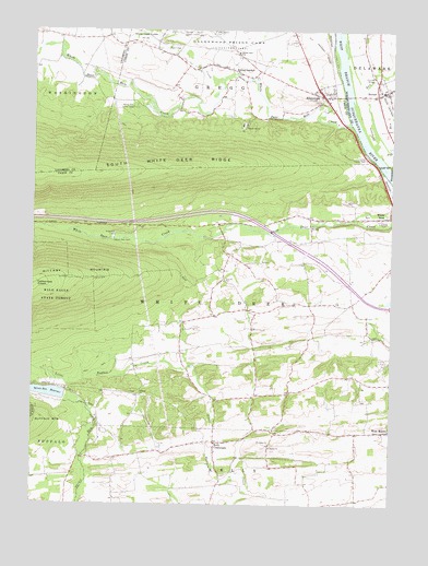
Allenwood, PA USGS Topographic Map
Click on map above to begin viewing in our Map Viewer.

This topographic map contains these locations and features:
Feature Name Type Latitude Longitude GNIS ID View Map
AllenwoodPopulated PlaceN41.1076°W76.8983°1168202View Map
Allenwood Census Designated PlaceCensusN41.1081°W76.8982°2584434View Map
Allenwood Post OfficePost OfficeN41.1081°W76.8993°2773061View Map
Catharines CrownSummitN41.0579°W76.9991°1192242View Map
Central SchoolSchoolN41.0440°W76.9027°1197318View Map
Delaware RunStreamN41.0934°W76.8805°1190978View Map
Devitt HomeLocaleN41.1001°W76.9264°1173213View Map
DewartPopulated PlaceN41.1092°W76.8766°1192356View Map
Dewart Post OfficePost OfficeN41.1084°W76.8794°2772667View Map
Dry RunStreamN41.0923°W76.8789°1173546View Map
Furnace School (historical)SchoolN41.0662°W76.9305°1197319View Map
Kelly CrossroadsPopulated PlaceN41.0165°W76.9355°1178333View Map
Moore SchoolSchoolN41.0118°W76.8972°1197313View Map
New Columbia Census Designated PlaceCensusN41.0423°W76.8763°2584492View Map
Old FurnacePopulated PlaceN41.0740°W76.9350°1197320View Map
Pleasant Creek SchoolSchoolN41.1231°W76.9875°1197322View Map
Ramsey SchoolSchoolN41.0351°W76.9450°1197316View Map
Robin SchoolSchoolN41.0334°W76.8861°1197317View Map
Saint Johns ChurchChurchN41.0156°W76.9175°1186154View Map
Saint Peters ChurchChurchN41.0156°W76.9164°1186676View Map
Spring CreekStreamN41.1123°W76.9344°1188221View Map
Spring GardenPopulated PlaceN41.1140°W76.9283°1188227View Map
Spruce Reservoir DamDamN41.0284°W76.9880°1195209View Map
Spruce Run ReservoirReservoirN41.0294°W76.9938°1188357View Map
Sunrise ChurchChurchN41.0290°W76.9627°1189084View Map
Sunrise SchoolSchoolN41.0298°W76.9744°1197315View Map
Township of GreggCivilN41.1148°W76.9324°1217130View Map
Township of White DeerCivilN41.0552°W76.9558°1217137View Map
West Milton Census Designated PlaceCensusN41.0183°W76.8766°2584526View Map
Wetzell SchoolSchoolN41.1184°W76.9530°1197321View Map
White Deer ChurchChurchN41.1192°W76.9289°1191266View Map
White Deer DamDamN41.0701°W76.9714°1191269View Map
White Deer Hole CreekStreamN41.1006°W76.8894°1191270View Map
White Deer Post OfficePost OfficeN41.0757°W76.8760°2773035View Map
White Deer ValleyValleyN41.1003°W76.8901°1197830View Map
White Deer Valley CampLocaleN41.1048°W76.9647°1191273View Map
Yokum SchoolSchoolN41.0698°W76.9030°1197323View Map

Note: Coordinates in the location and feature list above are referenced to NAD83 datum.


Copyright (C) 2008-2024 Ryan Niemi / Sunset Dynamics ... All Rights Reserved