TopoQuest Logo
Do you find TopoQuest useful?
Help keep TopoQuest running and adding new maps/features by donating!
Bitcoin:  19c7KJd3qBynnjoSw5npx9KScwjBe4ifkT
Litecoin:  LXs6TkuXGGXo1vDsWCkWVdjQX94eUKd6ui
Home View Maps Find Maps Find Places Resources & Links


Bloomburg, Texas Topographic Map

USGS Map Title: Bloomburg, TX
USGS Map MRC: 33094B1
DRG (GeoTIFF) Download: o33094b1.tif


Neighboring USGS Topographic Map Quads:


  Wright Patman Lake, TX  
33094C2
 

  Domino, TX  
33094C1
 

  Fouke, AR  
33093C8
 

  Atlanta North, TX  
33094B2
 

  Bloomburg, TX  
33094B1
 

  Doddridge NW, AR  
33093B8
 

  Atlanta South, TX  
33094A2
 

  Ravanna, AR  
33094A1
 

  Doddridge, AR  
33093A8


Map MRC Location:

N34°
W95°
N34°
W94°
H8 H7 H6 H5 H4 H3 H2 H1
G8 G7 G6 G5 G4 G3 G2 G1
F8 F7 F6 F5 F4 F3 F2 F1
E8 E7 E6 E5 E4 E3 E2 E1
D8 D7 D6 D5 D4 D3 D2 D1
C8 C7 C6 C5 C4 C3 C2 C1
B8 B7 B6 B5 B4 B3 B2 B1
A8 A7 A6 A5 A4 A3 A2 A1
N33°
W95°
N33°
W94°

Bloomburg, TX USGS 1:24K Topographic Map Preview:
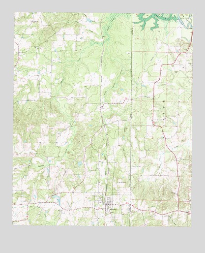
Bloomburg, TX USGS Topographic Map
Click on map above to begin viewing in our Map Viewer.

This topographic map contains these locations and features:
Feature Name Type Latitude Longitude GNIS ID View Map
Alex Smith Lake DamDamN33.2368°W94.0085°81188View Map
BloomburgPopulated PlaceN33.1379°W94.0574°1330880View Map
Bloomburg City HallBuildingN33.1380°W94.0579°2753126View Map
Bloomburg Post OfficePost OfficeN33.1343°W94.0598°2731082View Map
Bloomburg Volunteer Fire DepartmentBuildingN33.1376°W94.0573°2655223View Map
Camp CreekStreamN33.2368°W94.0621°1372888View Map
CassPopulated PlaceN33.1951°W94.0632°1378099View Map
Center Point ChurchChurchN33.2296°W94.1091°1332547View Map
Cypress CreekStreamN33.2351°W94.0582°1333854View Map
Golden Gate ChurchChurchN33.2443°W94.1119°1336654View Map
Grassy CreekStreamN33.2457°W94.0605°1373896View Map
International Paper Company DamDamN33.2451°W94.0702°1854973View Map
Jefferson County LibraryBuildingN33.1910°W94.0305°2014881View Map
Literacy DepotBuildingN33.2193°W94.1010°2014914View Map
Little Cypress CreekStreamN33.2351°W94.0582°1340074View Map
Long SloughLakeN33.2485°W94.0219°74996View Map
Long Slough DamDamN33.2468°W94.0102°81190View Map
Macedonia ChurchChurchN33.1449°W94.0102°51559View Map
Porterfield LakeReservoirN33.1617°W94.0784°1854976View Map
Porterfield Lake DamDamN33.1618°W94.0785°1854975View Map
Salem ChurchChurchN33.1343°W94.0905°1346172View Map
Sand Hill ChurchChurchN33.2010°W94.0324°54540View Map
Smith LakeReservoirN33.2374°W94.0106°81189View Map
Supervisors Club PondReservoirN33.2456°W94.0726°1854974View Map
Texas CreekStreamN33.1929°W94.0560°1348408View Map
Town of BloomburgCivilN33.1378°W94.0591°2411698View Map
Town of DominoCivilN33.2298°W94.1101°2412440View Map
Walters CemeteryCemeteryN33.2160°W94.0121°56024View Map

Note: Coordinates in the location and feature list above are referenced to NAD83 datum.


Copyright (C) 2008-2024 Ryan Niemi / Sunset Dynamics ... All Rights Reserved