TopoQuest Logo
Do you find TopoQuest useful?
Help keep TopoQuest running and adding new maps/features by donating!
Bitcoin:  19c7KJd3qBynnjoSw5npx9KScwjBe4ifkT
Litecoin:  LXs6TkuXGGXo1vDsWCkWVdjQX94eUKd6ui
Home View Maps Find Maps Find Places Resources & Links


Bloomsdale, Missouri Topographic Map

USGS Map Title: Bloomsdale, MO
USGS Map MRC: 38090A2
DRG (GeoTIFF) Download: o38090a2.tif


Neighboring USGS Topographic Map Quads:


  Selma, MO  
38090B3
 

  Renault, IL  
38090B2
 

  Ames, IL  
38090B1
 

  Danby, MO  
38090A3
 

  Bloomsdale, MO  
38090A2
 

  Prairie du Rocher, IL  
38090A1
 

  Lawrenceton, MO  
37090H3
 

  Weingarten, MO  
37090H2
 

  Sainte Genevieve, MO  
37090H1


Map MRC Location:

N39°
W91°
N39°
W90°
H8 H7 H6 H5 H4 H3 H2 H1
G8 G7 G6 G5 G4 G3 G2 G1
F8 F7 F6 F5 F4 F3 F2 F1
E8 E7 E6 E5 E4 E3 E2 E1
D8 D7 D6 D5 D4 D3 D2 D1
C8 C7 C6 C5 C4 C3 C2 C1
B8 B7 B6 B5 B4 B3 B2 B1
A8 A7 A6 A5 A4 A3 A2 A1
N38°
W91°
N38°
W90°

Bloomsdale, MO USGS 1:24K Topographic Map Preview:
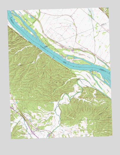
Bloomsdale, MO USGS Topographic Map
Click on map above to begin viewing in our Map Viewer.

This topographic map contains these locations and features:
Feature Name Type Latitude Longitude GNIS ID View Map
Ames Towhead (historical)IslandN38.1092°W90.2410°739944View Map
BackboneRidgeN38.0684°W90.1846°739947View Map
Bellville SchoolSchoolN38.0053°W90.1765°748178View Map
BloomsdalePopulated PlaceN38.0095°W90.2179°736278View Map
Bloomsdale Elementary SchoolSchoolN38.0335°W90.2446°714388View Map
Bloomsdale Post OfficePost OfficeN38.0085°W90.2174°2782952View Map
Bloomsdale Volunteer Fire DepartmentBuildingN38.0112°W90.2223°2620968View Map
Boxtown School (historical)SchoolN38.1106°W90.1676°1821648View Map
Brickey School (historical)SchoolN38.0770°W90.1434°1764819View Map
BrickeysPopulated PlaceN38.0845°W90.2107°740692View Map
Brickeys HollowValleyN38.0839°W90.2082°736282View Map
Cambria HollowValleyN38.0395°W90.1323°715225View Map
Carpenter BranchStreamN38.0014°W90.2257°738172View Map
City of BloomsdaleCivilN38.0146°W90.2213°2394199View Map
ClementPopulated PlaceN38.0570°W90.1654°740749View Map
Corn HollowValleyN38.0162°W90.2468°737609View Map
Durfee BarIslandN38.1233°W90.2429°2761588View Map
Establishment ChuteGutN38.0592°W90.1433°2761591View Map
Establishment IslandIslandN38.0545°W90.1484°717631View Map
Fort Cavendish (historical)MilitaryN38.0844°W90.1578°1820684View Map
Fort Chartres ChuteGutN38.0766°W90.1637°2761590View Map
Fort Chartres IslandIslandN38.0809°W90.1715°408544View Map
Fort Chartres State ParkParkN38.0848°W90.1584°408545View Map
Fourche a Du ClosStreamN38.0012°W90.2065°718129View Map
Hoeff School (historical)SchoolN38.1034°W90.1315°1764845View Map
Isle du Bois CreekStreamN38.1003°W90.2323°736311View Map
JawboneSummitN38.0734°W90.1951°739946View Map
KiddPopulated PlaceN38.1173°W90.1729°411454View Map
Kinsey CreekStreamN38.0153°W90.2418°736312View Map
Lee IslandIslandN38.1081°W90.2429°739945View Map
Morrison HollowValleyN38.0903°W90.2193°722659View Map
Mud BranchStreamN38.0117°W90.1896°738171View Map
NeedmorePopulated PlaceN38.0717°W90.2385°723142View Map
Old Maeystown CreekStreamN38.0984°W90.2151°415027View Map
Onemile Race CreekStreamN38.0701°W90.1454°415125View Map
Penitentiary PointCapeN38.1084°W90.2226°1821693View Map
Quarry HollowValleyN38.0887°W90.2153°737612View Map
Saint Philip (historical)Populated PlaceN38.1054°W90.1799°2729318View Map
Saint Philomenas Catholic ChurchChurchN38.0067°W90.2215°737613View Map
Salt Lake ChuteGutN38.1139°W90.2309°2761589View Map
Schmidts IslandIslandN38.0478°W90.1326°726107View Map
Snell HollowValleyN38.0775°W90.1974°726658View Map
Staples HollowValleyN38.0579°W90.1664°727012View Map
Stringtown School (historical)SchoolN38.1212°W90.2040°1821707View Map
Wolf HollowValleyN38.0983°W90.2323°729068View Map

Note: Coordinates in the location and feature list above are referenced to NAD83 datum.


Copyright (C) 2008-2024 Ryan Niemi / Sunset Dynamics ... All Rights Reserved