TopoQuest Logo
Do you find TopoQuest useful?
Help keep TopoQuest running and adding new maps/features by donating!
Bitcoin:  19c7KJd3qBynnjoSw5npx9KScwjBe4ifkT
Litecoin:  LXs6TkuXGGXo1vDsWCkWVdjQX94eUKd6ui
Home View Maps Find Maps Find Places Resources & Links


Prairie du Rocher, Illinois Topographic Map

USGS Map Title: Prairie du Rocher, IL
USGS Map MRC: 38090A1
DRG (GeoTIFF) Download: o38090a1.tif


Neighboring USGS Topographic Map Quads:


  Renault, IL  
38090B2
 

  Ames, IL  
38090B1
 

  Red Bud, IL  
38089B8
 

  Bloomsdale, MO  
38090A2
 

  Prairie du Rocher, IL  
38090A1
 

  Evansville, IL  
38089A8
 

  Weingarten, MO  
37090H2
 

  Sainte Genevieve, MO  
37090H1
 

  Kaskaskia, IL  
37089H8


Map MRC Location:

N39°
W91°
N39°
W90°
H8 H7 H6 H5 H4 H3 H2 H1
G8 G7 G6 G5 G4 G3 G2 G1
F8 F7 F6 F5 F4 F3 F2 F1
E8 E7 E6 E5 E4 E3 E2 E1
D8 D7 D6 D5 D4 D3 D2 D1
C8 C7 C6 C5 C4 C3 C2 C1
B8 B7 B6 B5 B4 B3 B2 B1
A8 A7 A6 A5 A4 A3 A2 A1
N38°
W91°
N38°
W90°

Prairie du Rocher, IL USGS 1:24K Topographic Map Preview:
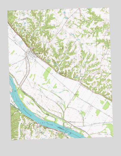
Prairie du Rocher, IL USGS Topographic Map
Click on map above to begin viewing in our Map Viewer.

This topographic map contains these locations and features:
Feature Name Type Latitude Longitude GNIS ID View Map
Barbeau HollowValleyN38.0747°W90.0618°403885View Map
Barbeau School (historical)SchoolN38.0498°W90.0959°1764815View Map
Brewerville Election PrecinctCivilN38.0235°W90.0053°1928452View Map
Burns HollowValleyN38.0548°W90.0402°405246View Map
Commons School (historical)SchoolN38.1026°W90.0518°1764829View Map
Cow Shank Natural BridgeArchN38.1200°W90.0808°2701932View Map
Crook LandingLocaleN38.0251°W90.1112°736371View Map
DanleyPopulated PlaceN38.0956°W90.1157°422604View Map
Establishment CreekStreamN38.0278°W90.1126°717630View Map
Fort Charters Sportsmans Club LakeReservoirN38.0584°W90.0418°1691885View Map
Fort Charters Sportsmans Club Lake DamDamN38.0584°W90.0418°1691884View Map
Frenchman CreekStreamN38.0262°W90.1109°736297View Map
Government Limestone QuarryMineN38.0073°W90.0671°737614View Map
Hayden School (historical)SchoolN38.1189°W90.1101°1821666View Map
Hughes School (historical)SchoolN38.0134°W90.0126°1764847View Map
KelloggPopulated PlaceN38.0159°W90.0546°422864View Map
Kertz Farms Lake DamDamN38.0051°W90.0684°765050View Map
Lawrence HollowValleyN38.0278°W90.1154°720845View Map
Little Rock LandingPopulated PlaceN38.0051°W90.0601°741018View Map
Lower Frenchman HollowValleyN38.0167°W90.0948°721639View Map
Magnolia HollowValleyN38.0326°W90.1240°721754View Map
MarigoldPopulated PlaceN38.0798°W90.0065°422939View Map
ModocPopulated PlaceN38.0526°W90.0373°413700View Map
ModocLocaleN38.0420°W90.0457°413701View Map
Modoc Post OfficePost OfficeN38.0523°W90.0371°1820692View Map
Modoc Rock ShelterLocaleN38.0628°W90.0637°1820693View Map
Modoc Rock Shelter National Historic SiteParkN38.0628°W90.0640°413702View Map
Moehrs School (historical)SchoolN38.0223°W90.0593°1764863View Map
Mudds LandingLocaleN38.0134°W90.0543°422204View Map
Prairie du RocherPopulated PlaceN38.0831°W90.0959°416094View Map
Prairie Du RocherFlatN38.0648°W90.0987°1820698View Map
Prairie Du Rocher Community Fire DepartmentBuildingN38.0859°W90.0982°2640928View Map
Prairie du Rocher CreekStreamN38.0476°W90.1165°426472View Map
Prairie du Rocher Election PrecinctCivilN38.0824°W90.1003°1928603View Map
Prairie Du Rocher Elementary SchoolSchoolN38.0798°W90.0937°1820699View Map
Sugar Bottom CreekStreamN38.0034°W90.1140°738174View Map
The DischargeStreamN38.0039°W90.0404°419629View Map
ThomurePopulated PlaceN38.0039°W90.0596°741320View Map
Turkey IslandIslandN38.0317°W90.0973°727873View Map
Village of Prairie du RocherCivilN38.0817°W90.0976°2399019View Map
WhitesandLocaleN38.0189°W90.1151°735999View Map

Note: Coordinates in the location and feature list above are referenced to NAD83 datum.


Copyright (C) 2008-2024 Ryan Niemi / Sunset Dynamics ... All Rights Reserved