TopoQuest Logo
Do you find TopoQuest useful?
Help keep TopoQuest running and adding new maps/features by donating!
Bitcoin:  19c7KJd3qBynnjoSw5npx9KScwjBe4ifkT
Litecoin:  LXs6TkuXGGXo1vDsWCkWVdjQX94eUKd6ui
Home View Maps Find Maps Find Places Resources & Links


Eldridge East, Missouri Topographic Map

USGS Map Title: Eldridge East, MO
USGS Map MRC: 37092G6
DRG (GeoTIFF) Download: o37092g6.tif


Neighboring USGS Topographic Map Quads:


  Hahatonka, MO  
37092H7
 

  Decaturville, MO  
37092H6
 

  Montreal, MO  
37092H5
 

  Eldridge West, MO  
37092G7
 

  Eldridge East, MO  
37092G6
 

  Stoutland, MO  
37092G5
 

  Bennett Springs, MO  
37092F7
 

  Lebanon, MO  
37092F6
 

  Oakland, MO  
37092F5


Map MRC Location:

N38°
W93°
N38°
W92°
H8 H7 H6 H5 H4 H3 H2 H1
G8 G7 G6 G5 G4 G3 G2 G1
F8 F7 F6 F5 F4 F3 F2 F1
E8 E7 E6 E5 E4 E3 E2 E1
D8 D7 D6 D5 D4 D3 D2 D1
C8 C7 C6 C5 C4 C3 C2 C1
B8 B7 B6 B5 B4 B3 B2 B1
A8 A7 A6 A5 A4 A3 A2 A1
N37°
W93°
N37°
W92°

Eldridge East, MO USGS 1:24K Topographic Map Preview:
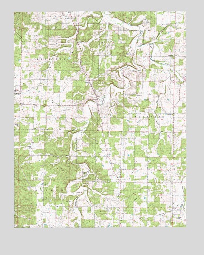
Eldridge East, MO USGS Topographic Map
Click on map above to begin viewing in our Map Viewer.

This topographic map contains these locations and features:
Feature Name Type Latitude Longitude GNIS ID View Map
Alexander School (historical)SchoolN37.8300°W92.7177°735016View Map
BidwellPopulated PlaceN37.8717°W92.7096°740677View Map
Bradshaw CemeteryCemeteryN37.7967°W92.7374°714619View Map
Butcher CemeteryCemeteryN37.8095°W92.7471°715116View Map
Capoferri LakeReservoirN37.7509°W92.6817°763752View Map
Capoferri Lake DamDamN37.7517°W92.6818°763751View Map
Davis CemeteryCemeteryN37.8500°W92.6674°716716View Map
DovePopulated PlaceN37.7909°W92.6827°717018View Map
Dove ChurchChurchN37.7900°W92.6818°735017View Map
DryglaizeLocaleN37.8059°W92.6357°740363View Map
EldridgePopulated PlaceN37.8298°W92.7491°717440View Map
Eldridge Post OfficePost OfficeN37.8294°W92.7472°2782610View Map
Eldridge Volunteer Fire DepartmentBuildingN37.8254°W92.7453°2620673View Map
Esther BranchStreamN37.8564°W92.6499°717634View Map
Friendship ChurchChurchN37.8153°W92.6349°718240View Map
Friendship SchoolLocaleN37.8150°W92.6341°742492View Map
Fulbright CemeteryCemeteryN37.7703°W92.7007°718278View Map
Goodwin Calvary ChurchChurchN37.8686°W92.6524°718576View Map
Goodwin HollowValleyN37.8539°W92.6632°718578View Map
Goodwin Hollow CreekStreamN37.8559°W92.6627°735026View Map
Goodwin SchoolSchoolN37.8686°W92.6524°742076View Map
Goss PondLakeN37.7620°W92.6291°718634View Map
GracePopulated PlaceN37.8575°W92.7446°740881View Map
High HollowValleyN37.8425°W92.6396°719533View Map
Holman CemeteryCemeteryN37.7553°W92.6316°719726View Map
Holman HollowValleyN37.7639°W92.6302°719727View Map
Hufft CemeteryCemeteryN37.8381°W92.7310°719965View Map
Hufft HollowValleyN37.8175°W92.6496°719966View Map
Keener SchoolLocaleN37.7845°W92.7202°742493View Map
KIRK-FM (Lebanon)TowerN37.8195°W92.7477°754250View Map
Liberty CemeteryCemeteryN37.8495°W92.6343°720959View Map
Liberty Church (historical)ChurchN37.8500°W92.6343°742490View Map
Merchant SchoolSchoolN37.7831°W92.6638°742494View Map
Mizer CemeteryCemeteryN37.7653°W92.7091°722504View Map
Reagan ChurchChurchN37.8261°W92.6616°725143View Map
Reagan PondLakeN37.8240°W92.6555°725144View Map
Reagan School (historical)LocaleN37.8267°W92.6613°742491View Map
Rogers CemeteryCemeteryN37.7811°W92.7004°725533View Map
Shith CemeteryCemeteryN37.8745°W92.6830°726391View Map
Township of AuglaizeCivilN37.8046°W92.6425°766857View Map
Zion ChurchChurchN37.8709°W92.7113°729242View Map
Zion SchoolSchoolN37.8709°W92.7113°742077View Map

Note: Coordinates in the location and feature list above are referenced to NAD83 datum.


Copyright (C) 2008-2024 Ryan Niemi / Sunset Dynamics ... All Rights Reserved