TopoQuest Logo
Do you find TopoQuest useful?
Help keep TopoQuest running and adding new maps/features by donating!
Bitcoin:  19c7KJd3qBynnjoSw5npx9KScwjBe4ifkT
Litecoin:  LXs6TkuXGGXo1vDsWCkWVdjQX94eUKd6ui
Home View Maps Find Maps Find Places Resources & Links


Reynolds, Illinois Topographic Map

USGS Map Title: Reynolds, IL
USGS Map MRC: 41090C6
DRG (GeoTIFF) Download: o41090c6.tif


Neighboring USGS Topographic Map Quads:


  Montpelier, IA  
41090D7
 

  Andalusia, IL  
41090D6
 

  Milan, IL  
41090D5
 

  Buffalo Prairie, IL  
41090C7
 

  Reynolds, IL  
41090C6
 

  Matherville, IL  
41090C5
 

  Aledo West, IL  
41090B7
 

  Aledo East, IL  
41090B6
 

  Viola, IL  
41090B5


Map MRC Location:

N42°
W91°
N42°
W90°
H8 H7 H6 H5 H4 H3 H2 H1
G8 G7 G6 G5 G4 G3 G2 G1
F8 F7 F6 F5 F4 F3 F2 F1
E8 E7 E6 E5 E4 E3 E2 E1
D8 D7 D6 D5 D4 D3 D2 D1
C8 C7 C6 C5 C4 C3 C2 C1
B8 B7 B6 B5 B4 B3 B2 B1
A8 A7 A6 A5 A4 A3 A2 A1
N41°
W91°
N41°
W90°

Reynolds, IL USGS 1:24K Topographic Map Preview:
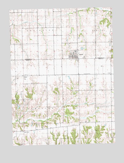
Reynolds, IL USGS Topographic Map
Click on map above to begin viewing in our Map Viewer.

This topographic map contains these locations and features:
Feature Name Type Latitude Longitude GNIS ID View Map
Centennial School (historical)SchoolN41.3556°W90.6468°405783View Map
Corns CemeteryCemeteryN41.2678°W90.6726°406601View Map
Enon Church (historical)ChurchN41.2623°W90.6835°1808626View Map
Fairview School (historical)SchoolN41.3134°W90.6476°1808627View Map
Gingle CornersPopulated PlaceN41.2631°W90.7360°422739View Map
Gray CemeteryCemeteryN41.2997°W90.7090°409349View Map
HamletPopulated PlaceN41.3139°W90.7351°409704View Map
Hamlet CemeteryCemeteryN41.3120°W90.7440°409705View Map
Mercer County AirportAirportN41.2510°W90.7369°427006View Map
Monitor School (historical)SchoolN41.3439°W90.7446°413725View Map
North Camp CreekStreamN41.2784°W90.6951°414575View Map
Perryton ChurchChurchN41.2636°W90.7363°415568View Map
Perryton School (historical)SchoolN41.2628°W90.7399°415569View Map
Prairie Union School (historical)SchoolN41.3509°W90.6974°416171View Map
ReynoldsPopulated PlaceN41.3298°W90.6704°416566View Map
Reynolds CemeteryCemeteryN41.3331°W90.6760°1967981View Map
Reynolds Elementary SchoolSchoolN41.3314°W90.6751°2042122View Map
Reynolds Fire Protection DistrictBuildingN41.3283°W90.6674°2640175View Map
Reynolds Post OfficePost OfficeN41.3298°W90.6696°2788489View Map
Saint Johns ChurchChurchN41.3139°W90.6279°417403View Map
Saint Joseph Church (historical)ChurchN41.2695°W90.6496°417448View Map
Saint Joseph's CemeteryCemeteryN41.2622°W90.6496°417481View Map
Township of EdgingtonCivilN41.3724°W90.7249°428942View Map
Township of PerrytonCivilN41.2849°W90.7258°429551View Map
Village of ReynoldsCivilN41.3319°W90.6721°2399061View Map

Note: Coordinates in the location and feature list above are referenced to NAD83 datum.


Copyright (C) 2008-2024 Ryan Niemi / Sunset Dynamics ... All Rights Reserved