TopoQuest Logo
Do you find TopoQuest useful?
Help keep TopoQuest running and adding new maps/features by donating!
Bitcoin:  19c7KJd3qBynnjoSw5npx9KScwjBe4ifkT
Litecoin:  LXs6TkuXGGXo1vDsWCkWVdjQX94eUKd6ui
Home View Maps Find Maps Find Places Resources & Links


Carrier Mills, Illinois Topographic Map

USGS Map Title: Carrier Mills, IL
USGS Map MRC: 37088F6
DRG (GeoTIFF) Download: o37088f6.tif


Neighboring USGS Topographic Map Quads:


  Pittsburg, IL  
37088G7
 

  Harco, IL  
37088G6
 

  Galatia, IL  
37088G5
 

  Crab Orchard, IL  
37088F7
 

  Carrier Mills, IL  
37088F6
 

  Harrisburg, IL  
37088F5
 

  Creal Springs, IL  
37088E7
 

  Stonefort, IL  
37088E6
 

  Eddyville, IL  
37088E5


Map MRC Location:

N38°
W89°
N38°
W88°
H8 H7 H6 H5 H4 H3 H2 H1
G8 G7 G6 G5 G4 G3 G2 G1
F8 F7 F6 F5 F4 F3 F2 F1
E8 E7 E6 E5 E4 E3 E2 E1
D8 D7 D6 D5 D4 D3 D2 D1
C8 C7 C6 C5 C4 C3 C2 C1
B8 B7 B6 B5 B4 B3 B2 B1
A8 A7 A6 A5 A4 A3 A2 A1
N37°
W89°
N37°
W88°

Carrier Mills, IL USGS 1:24K Topographic Map Preview:
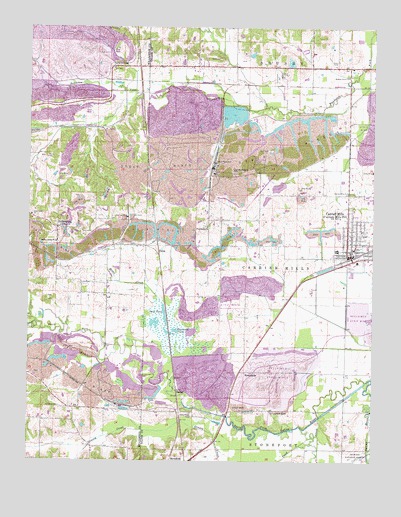
Carrier Mills, IL USGS Topographic Map
Click on map above to begin viewing in our Map Viewer.

This topographic map contains these locations and features:
Feature Name Type Latitude Longitude GNIS ID View Map
Barter CemeteryCemeteryN37.7495°W88.7198°403292View Map
Black School (historical)SchoolN37.7006°W88.7264°1737344View Map
Black SloughStreamN37.6548°W88.7064°404503View Map
Blue Bird Mine Number 7MineN37.7370°W88.7270°424655View Map
Brier CreekStreamN37.6703°W88.7037°404860View Map
Bunker Hill School (historical)SchoolN37.7125°W88.6942°1820946View Map
Carmac MineMineN37.6953°W88.7145°405609View Map
Carrier MillsPopulated PlaceN37.6842°W88.6328°405634View Map
Carrier Mills Elementary SchoolSchoolN37.6862°W88.6323°1820949View Map
Carrier Mills Fire DepartmentBuildingN37.6841°W88.6350°2681828View Map
Carrier Mills High SchoolSchoolN37.6825°W88.6309°1820950View Map
Carrier Mills ParkParkN37.7025°W88.6331°405635View Map
Carrier Mills Police DepartmentBuildingN37.6839°W88.6350°2758979View Map
Carrier Mills Post OfficePost OfficeN37.6840°W88.6341°2788858View Map
Cottonwood PondLakeN37.6625°W88.6966°406638View Map
Dallasania Church (historical)ChurchN37.7389°W88.6848°1820955View Map
DeltaPopulated PlaceN37.6842°W88.7028°422615View Map
DykersburgPopulated PlaceN37.6923°W88.7398°407554View Map
Dykersburg SchoolSchoolN37.6956°W88.7489°407555View Map
Harris School (historical)SchoolN37.6870°W88.6576°1820981View Map
Henshaw CemeteryCemeteryN37.6406°W88.7381°410080View Map
Henshaw School (historical)SchoolN37.6406°W88.7387°1820982View Map
Holmes School (historical)SchoolN37.6795°W88.6806°1820983View Map
Indian Camp ChurchChurchN37.6878°W88.7403°410828View Map
Jenny Ridge CemeteryCemeteryN37.6389°W88.6909°411091View Map
Mayhew School (historical)SchoolN37.7289°W88.7267°1737320View Map
Moores Grove ParkParkN37.7367°W88.6345°413792View Map
New Spring Grove CemeteryCemeteryN37.7387°W88.7192°403309View Map
NewcastlePopulated PlaceN37.6506°W88.6714°423020View Map
Newcastle School (historical)SchoolN37.6512°W88.6717°1820993View Map
Open PondLakeN37.6672°W88.7005°415139View Map
Peabody-Will Scarlet HeliportAirportN37.6400°W88.7089°427850View Map
Pond CreekStreamN37.6373°W88.6445°425344View Map
Providence ChurchChurchN37.6925°W88.6856°416250View Map
Rock CreekStreamN37.7325°W88.7362°416798View Map
Sahara Mine Number 5MineN37.7109°W88.6826°425432View Map
Sahara Mine Number 7MineN37.7362°W88.6584°1821004View Map
SalinePopulated PlaceN37.6453°W88.6959°423149View Map
Shelton School (historical)SchoolN37.6770°W88.7312°1821014View Map
South America ChurchChurchN37.7089°W88.6762°418710View Map
Spring Grove ChurchChurchN37.7384°W88.7201°418961View Map
Sugar CreekStreamN37.6648°W88.7470°425531View Map
Township of Carrier MillsCivilN37.6894°W88.6508°428765View Map
Trout Family CemeteryCemeteryN37.7403°W88.6387°419890View Map
Village of Carrier MillsCivilN37.6885°W88.6294°2397561View Map
Ward CemeteryCemeteryN37.7412°W88.6814°420516View Map
Wasson Mine Number 2MineN37.6909°W88.6587°1821023View Map

Note: Coordinates in the location and feature list above are referenced to NAD83 datum.


Copyright (C) 2008-2024 Ryan Niemi / Sunset Dynamics ... All Rights Reserved