TopoQuest Logo
Do you find TopoQuest useful?
Help keep TopoQuest running and adding new maps/features by donating!
Bitcoin:  19c7KJd3qBynnjoSw5npx9KScwjBe4ifkT
Litecoin:  LXs6TkuXGGXo1vDsWCkWVdjQX94eUKd6ui
Home View Maps Find Maps Find Places Resources & Links


Christiansburg, Ohio Topographic Map

USGS Map Title: Christiansburg, OH
USGS Map MRC: 40084A1
DRG (GeoTIFF) Download: o40084a1.tif


Neighboring USGS Topographic Map Quads:


  Piqua East, OH  
40084B2
 

  Fletcher, OH  
40084B1
 

  Saint Paris, OH  
40083B8
 

  Troy, OH  
40084A2
 

  Christiansburg, OH  
40084A1
 

  Thackery, OH  
40083A8
 

  Tipp City, OH  
39084H2
 

  New Carlisle, OH  
39084H1
 

  Donnelsville, OH  
39083H8


Map MRC Location:

N41°
W85°
N41°
W84°
H8 H7 H6 H5 H4 H3 H2 H1
G8 G7 G6 G5 G4 G3 G2 G1
F8 F7 F6 F5 F4 F3 F2 F1
E8 E7 E6 E5 E4 E3 E2 E1
D8 D7 D6 D5 D4 D3 D2 D1
C8 C7 C6 C5 C4 C3 C2 C1
B8 B7 B6 B5 B4 B3 B2 B1
A8 A7 A6 A5 A4 A3 A2 A1
N40°
W85°
N40°
W84°

Christiansburg, OH USGS 1:24K Topographic Map Preview:
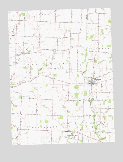
Christiansburg, OH USGS Topographic Map
Click on map above to begin viewing in our Map Viewer.

This topographic map contains these locations and features:
Feature Name Type Latitude Longitude GNIS ID View Map
AlconyPopulated PlaceN40.0114°W84.0580°1048450View Map
Alcony Post Office (historical)Post OfficeN40.0112°W84.0583°2037146View Map
Alcony School (historical)SchoolN40.0103°W84.0472°1066472View Map
Bair FarmsLocaleN40.0914°W84.0947°2723074View Map
Bel Mar FarmsLocaleN40.0494°W84.1131°2723077View Map
Bobolink PondReservoirN40.0680°W84.0032°2790782View Map
Bodenmiller FarmsLocaleN40.0692°W84.1156°2723073View Map
Bright CemeteryCemeteryN40.0637°W84.0816°1038312View Map
Brown School (historical)SchoolN40.1153°W84.1044°1066536View Map
Burr Oak School (historical)SchoolN40.0873°W84.0872°1065496View Map
Butler FarmLocaleN40.0408°W84.0464°2723075View Map
Casstown Community Volunteer Fire CompanyBuildingN40.0541°W84.1248°2550586View Map
Castle Hill FarmLocaleN40.0572°W84.0633°2723081View Map
ChristiansburgPopulated PlaceN40.0553°W84.0260°1060962View Map
Christiansburg Fire CompanyBuildingN40.0562°W84.0270°2550227View Map
Christiansburg Post OfficePost OfficeN40.0556°W84.0263°1965187View Map
Circle G FarmLocaleN40.0714°W84.1214°2723080View Map
Dade FieldAirportN40.0511°W84.0112°2442501View Map
Double J FarmLocaleN40.0156°W84.1108°2723141View Map
Enterprise ChurchChurchN40.0951°W84.0222°1040218View Map
Fairview School (historical)SchoolN40.0287°W84.1127°1065497View Map
Fletcher Brown Township Emergency Medical ServicesBuildingN40.1247°W84.1107°2550721View Map
Fletcher Volunteer Fire DepartmentBuildingN40.1243°W84.1111°2550149View Map
Garden Stone GreenhouseBuildingN40.0200°W84.0594°2723144View Map
Haven ViewPopulated PlaceN40.0076°W84.0580°1048825View Map
Henger FarmsLocaleN40.0408°W84.0475°2723076View Map
Hill Grove School (historical)SchoolN40.0564°W84.0538°1053976View Map
Honey Creek CemeteryCemeteryN40.0201°W84.0177°1961166View Map
Honey Creek ChurchChurchN40.0198°W84.0177°1041735View Map
Honey Creek ChurchChurchN40.0762°W84.0216°1066753View Map
Huddleston-Sills CemeteryCemeteryN40.0773°W84.0238°1041847View Map
Johnston CemeteryCemeteryN40.0902°W84.0501°1070794View Map
Karnehm FarmLocaleN40.1033°W84.0439°2723066View Map
Killdeer Ridge FarmsLocaleN40.0542°W84.0522°2723079View Map
Lewis CemeteryCemeteryN40.0578°W84.1113°1042500View Map
Long CemeteryCemeteryN40.0131°W84.0216°1042735View Map
Lost Creek CemeteryCemeteryN40.0762°W84.1186°1042789View Map
Lost Creek ChurchChurchN40.0878°W84.0694°1066535View Map
Lost Creek SchoolSchoolN40.0539°W84.1230°1057818View Map
Lostcreek Baptist Church (historical)ChurchN40.0756°W84.1180°1069023View Map
Lostcreek German Baptist Church (historical)ChurchN40.1020°W84.1158°1069024View Map
McNeal DitchCanalN40.0092°W84.0641°1043141View Map
Meek CemeteryCemeteryN40.0450°W84.0588°1043207View Map
Miami East High SchoolSchoolN40.0851°W84.1158°1043250View Map
Moore School (historical)SchoolN40.0845°W84.0508°1065499View Map
Morton School (historical)SchoolN40.1126°W84.0580°1065500View Map
Pleasant Hill School (historical)SchoolN40.0264°W84.0735°1065501View Map
Providence Baptist Church (historical)ChurchN40.0634°W84.0813°1069028View Map
Rat Fork FarmLocaleN40.0667°W84.0500°2723078View Map
Rugged Hill School (historical)SchoolN40.0592°W84.1013°1054014View Map
Salem Presbyterian Church (historical)ChurchN40.0578°W84.1111°1069030View Map
School Number 6 (historical)SchoolN40.0834°W84.1177°1065502View Map
Sills CemeteryCemeteryN40.0409°W84.0260°1046267View Map
Smith CemeteryCemeteryN40.0534°W84.0213°1046363View Map
Sodom (historical)Populated PlaceN40.0873°W84.0710°1069032View Map
Sodom CemeteryCemeteryN40.0881°W84.0697°1046419View Map
Suber FarmsLocaleN40.1178°W84.1206°2723071View Map
Township of ElizabethCivilN40.0063°W84.0959°1086637View Map
Township of LostcreekCivilN40.0784°W84.0896°1086638View Map
Upper Honey Creek CemeteryCemeteryN40.0770°W84.0210°1961159View Map
Village of ChristiansburgCivilN40.0565°W84.0253°2397624View Map
Volk Fruit FarmsLocaleN40.0425°W84.0317°2723082View Map
Wesley Chapel Methodist Episcopal Church (historical)ChurchN40.1023°W84.0499°1069036View Map
Yingst FarmsLocaleN40.1189°W84.1022°2723072View Map
Youtsey CemeteryCemeteryN40.0864°W84.1102°1048217View Map

Note: Coordinates in the location and feature list above are referenced to NAD83 datum.


Copyright (C) 2008-2024 Ryan Niemi / Sunset Dynamics ... All Rights Reserved