TopoQuest Logo
Do you find TopoQuest useful?
Help keep TopoQuest running and adding new maps/features by donating!
Bitcoin:  19c7KJd3qBynnjoSw5npx9KScwjBe4ifkT
Litecoin:  LXs6TkuXGGXo1vDsWCkWVdjQX94eUKd6ui
Home View Maps Find Maps Find Places Resources & Links


Coosa Bald, Georgia Topographic Map

USGS Map Title: Coosa Bald, GA
USGS Map MRC: 34083G8
DRG (GeoTIFF) Download: o34083g8.tif


Neighboring USGS Topographic Map Quads:


  Nottely Dam, GA  
34084H1
 

  Blairsville, GA  
34083H8
 

  Hiawassee, GA  
34083H7
 

  Mulky Gap, GA  
34084G1
 

  Coosa Bald, GA  
34083G8
 

  Jacks Gap, GA  
34083G7
 

  Suches, GA  
34084F1
 

  Neels Gap, GA  
34083F8
 

  Cowrock, GA  
34083F7


Map MRC Location:

N35°
W84°
N35°
W83°
H8 H7 H6 H5 H4 H3 H2 H1
G8 G7 G6 G5 G4 G3 G2 G1
F8 F7 F6 F5 F4 F3 F2 F1
E8 E7 E6 E5 E4 E3 E2 E1
D8 D7 D6 D5 D4 D3 D2 D1
C8 C7 C6 C5 C4 C3 C2 C1
B8 B7 B6 B5 B4 B3 B2 B1
A8 A7 A6 A5 A4 A3 A2 A1
N34°
W84°
N34°
W83°

Coosa Bald, GA USGS 1:24K Topographic Map Preview:
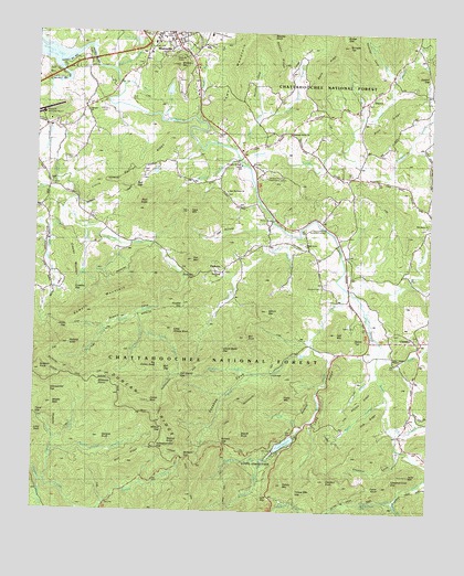
Coosa Bald, GA USGS Topographic Map
Click on map above to begin viewing in our Map Viewer.

This topographic map contains these locations and features:
Feature Name Type Latitude Longitude GNIS ID View Map
Akins CreekStreamN34.8451°W83.9363°326924View Map
Allison BranchStreamN34.7865°W83.8910°326936View Map
Allison RidgeRidgeN34.7787°W83.8944°326939View Map
Anderson CreekStreamN34.8506°W83.9955°326951View Map
Arkaqua CreekStreamN34.8401°W83.9341°326964View Map
Ben KnobSummitN34.7959°W83.9332°331130View Map
Berry School (historical)SchoolN34.8054°W83.9044°353081View Map
Bethel CemeteryCemeteryN34.8570°W83.8957°353084View Map
Bethel ChurchChurchN34.8587°W83.8938°354634View Map
Big BranchStreamN34.7731°W83.8866°327103View Map
Big Grassy KnobSummitN34.7884°W83.9602°331161View Map
Blairsville AirportAirportN34.8528°W83.9988°351687View Map
Blairsville Baptist ChurchChurchN34.8734°W83.9627°353087View Map
Blairsville CemeteryCemeteryN34.8731°W83.9618°353089View Map
Blairsville DivisionCivilN34.8309°W83.9400°1936113View Map
Blairsville Methodist ChurchChurchN34.8645°W83.9507°353090View Map
Blairsville QuarryMineN34.8603°W83.9561°2559507View Map
Blairsville-Suches Division (historical)CensusN34.8054°W83.9702°1936114View Map
Board Camp CreekStreamN34.7651°W83.9938°327185View Map
Bony BranchStreamN34.8615°W83.9719°327195View Map
Bowers CoveValleyN34.7975°W83.9789°327200View Map
Bowers MountainSummitN34.8018°W83.9832°331214View Map
Bridge GapGapN34.8745°W83.9032°327219View Map
Buckeye KnobSummitN34.7873°W83.9982°327269View Map
Bull GapGapN34.7868°W83.9588°327281View Map
Burnett BranchStreamN34.7631°W83.9263°327288View Map
Burnett GapGapN34.7681°W83.9394°327293View Map
Butt CemeteryCemeteryN34.8579°W83.9707°330575View Map
Butternut CreekStreamN34.8654°W83.9749°327308View Map
Caldwell (historical)Populated PlaceN34.8731°W83.8796°1705078View Map
Caldwell LakeReservoirN34.8599°W83.9584°339620View Map
Caldwell Lake DamDamN34.8601°W83.9582°339619View Map
Calf Stomp GapGapN34.7862°W83.9538°327323View Map
Calf Stump BranchStreamN34.7970°W83.9652°328617View Map
Center School (historical)SchoolN34.8512°W83.8966°353096View Map
Chestnut CoveValleyN34.7664°W83.8837°327435View Map
Chestnut Cove GapGapN34.7584°W83.8860°327437View Map
Chestnut KnobSummitN34.7584°W83.9066°355143View Map
ChoestoePopulated PlaceN34.7954°W83.8871°331396View Map
Choestoe Baptist ChurchChurchN34.7956°W83.8796°353099View Map
Choestoe CemeteryCemeteryN34.7962°W83.8799°353100View Map
Choestoe School (historical)SchoolN34.7965°W83.8782°353101View Map
Cindy CoveBasinN34.7693°W83.9035°327461View Map
Cob RidgeRidgeN34.7743°W83.8921°327477View Map
Cooks CoveBasinN34.8693°W83.9163°355279View Map
Cooks Cove BranchStreamN34.8548°W83.9285°327514View Map
Coosa Backcountry TrailTrailN34.7887°W83.9241°330978View Map
Coosa BaldSummitN34.7790°W83.9635°327522View Map
Coosa CemeteryCemeteryN34.8354°W83.9946°353106View Map
Coosa ChurchChurchN34.8356°W83.9949°355298View Map
Coosa CreekStreamN34.8584°W83.9935°354238View Map
Coosa School (historical)SchoolN34.8343°W83.9930°353107View Map
Crawley GapGapN34.8079°W83.9877°327551View Map
Crawley MountainSummitN34.8131°W83.9891°331474View Map
Davis RidgeRidgeN34.8668°W83.9063°327609View Map
Duncan CemeteryCemeteryN34.8412°W83.9888°327713View Map
Duncan RidgeRidgeN34.7598°W83.9499°327716View Map
East Fork Coosa CreekStreamN34.8290°W83.9916°327733View Map
Epps MountainSummitN34.8290°W83.9513°327770View Map
Fairview ChurchChurchN34.8543°W83.9841°355765View Map
Fairview School (historical)SchoolN34.8545°W83.9846°353113View Map
Faith ChurchChurchN34.8662°W83.9674°353114View Map
Fields BranchStreamN34.8526°W83.9491°327812View Map
Fisher KnobSummitN34.7570°W83.8891°331712View Map
Fort MountainSummitN34.8162°W83.9499°331753View Map
Fortenberry CreekStreamN34.8229°W83.9194°327863View Map
Frady BranchStreamN34.7826°W83.9091°327871View Map
Frady MountainSummitN34.7801°W83.9210°331766View Map
Garland KnobSummitN34.7690°W83.9788°331792View Map
Garrett CreekStreamN34.7579°W83.9980°327921View Map
Georgia Mountain Experiment StationLocaleN34.8368°W83.9266°356000View Map
Gillespie BranchStreamN34.8237°W83.9844°327933View Map
Goober GapGapN34.8651°W83.8763°327958View Map
Grace Calvary MissionChurchN34.7901°W83.8860°329021View Map
Harmony Grove CemeteryCemeteryN34.8484°W83.9196°353120View Map
Harmony Grove ChurchChurchN34.8487°W83.9194°356194View Map
Harmony Grove School (historical)SchoolN34.8490°W83.9194°353121View Map
Hatchet CreekStreamN34.7534°W83.8855°328086View Map
Helton Creek FallsFallsN34.7526°W83.8957°330576View Map
Henson CemeteryCemeteryN34.8090°W83.9088°328114View Map
Hogpen BranchStreamN34.7520°W83.9007°328185View Map
Hood (historical)Populated PlaceN34.8329°W83.8994°1705079View Map
Hospital CoveValleyN34.8644°W83.8873°328234View Map
Jacks MountainSummitN34.7601°W83.8805°332078View Map
Jones BranchStreamN34.7979°W83.9774°328348View Map
Jones GapGapN34.7979°W83.9891°328359View Map
Lake TrahlytaReservoirN34.7681°W83.9200°328429View Map
Lake Trahlyta DamDamN34.7698°W83.9169°336913View Map
Lance BranchStreamN34.7723°W83.9146°328438View Map
Lark GapGapN34.7540°W83.9246°328445View Map
Laura (historical)Populated PlaceN34.8162°W83.9110°353128View Map
Lawrence BranchStreamN34.8529°W83.9599°328458View Map
Little BaldSummitN34.7709°W83.9996°328522View Map
Little Duncan RidgeRidgeN34.8368°W83.9710°328543View Map
Little Grassy KnobSummitN34.7979°W83.9560°332233View Map
Locust Stake GapGapN34.7926°W83.9399°328602View Map
Logan CreekStreamN34.7579°W83.9957°328604View Map
Long BranchStreamN34.8645°W83.8868°328624View Map
Long RidgeRidgeN34.7806°W83.9063°328639View Map
Mathis CemeteryCemeteryN34.8548°W83.9780°328725View Map
Middle BaldSummitN34.7779°W83.9941°332380View Map
Miller CoveValleyN34.8127°W83.9935°328798View Map
Miller Cove BranchStreamN34.8234°W83.9955°328799View Map
Morgan BranchStreamN34.8431°W83.9357°328840View Map
Morgan BridgeBridgeN34.8415°W83.9346°328841View Map
Nance Payne CoveValleyN34.7522°W83.8877°328969View Map
Nelson CoveValleyN34.8544°W83.9291°328982View Map
Nelson RidgeRidgeN34.8698°W83.9241°328985View Map
New Harmony CemeteryCemeteryN34.8334°W83.9393°353145View Map
New Harmony ChurchChurchN34.8337°W83.9388°328998View Map
New Hope ChurchChurchN34.8129°W83.9424°329009View Map
Nicholson BridgeBridgeN34.8245°W83.9082°329030View Map
Old Liberty CemeteryCemeteryN34.8251°W83.8771°353153View Map
Old Liberty ChurchChurchN34.8251°W83.8760°329092View Map
Old Liberty School (historical)SchoolN34.8245°W83.8763°353154View Map
Otto (historical)Populated PlaceN34.8198°W83.9796°1705080View Map
Owl HollowBasinN34.8234°W83.9407°329114View Map
OwltownPopulated PlaceN34.8131°W83.9399°332586View Map
Owltown CemeteryCemeteryN34.8206°W83.9260°353156View Map
Owltown CemeteryCemeteryN34.8206°W83.9263°353162View Map
Owltown GapGapN34.8118°W83.9494°329117View Map
Picketts KnobSummitN34.7934°W83.9888°332656View Map
Pine RidgeRidgeN34.8518°W83.8877°329223View Map
Pineflat GapGapN34.8037°W83.9527°329228View Map
Reece BridgeBridgeN34.8265°W83.9244°329390View Map
Rich CemeteryCemeteryN34.8384°W83.9655°329415View Map
Rich GapGapN34.8351°W83.9685°329419View Map
Rich KnobSummitN34.8306°W83.9638°332841View Map
Rich RidgeRidgeN34.7631°W83.9694°329422View Map
Roaring ForkStreamN34.8020°W83.9674°329448View Map
Salem CemeteryCemeteryN34.7987°W83.8977°329568View Map
Salem TopSummitN34.7954°W83.8982°332961View Map
Sasebee Cove Scenic AreaLocaleN34.7612°W83.9466°330844View Map
Scruggs TopSummitN34.8723°W83.9018°332998View Map
Self MountainSummitN34.7968°W83.9046°333005View Map
Shady Grove CemeteryCemeteryN34.8195°W83.9149°353179View Map
Shady Grove ChurchChurchN34.8198°W83.9144°329644View Map
Shady Grove School (historical)SchoolN34.8195°W83.9146°353180View Map
Shadydale School (historical)SchoolN34.8212°W83.9260°353181View Map
Sheriff KnobSummitN34.7704°W83.9335°333030View Map
Sosebee CoveValleyN34.7851°W83.9306°329761View Map
Spiva BranchStreamN34.7812°W83.8882°329785View Map
Stewart CoveValleyN34.8336°W83.9959°329831View Map
Stewart CreekStreamN34.8343°W83.9957°329832View Map
Stink CreekStreamN34.7940°W83.8896°329845View Map
Tigue BranchStreamN34.7679°W83.9935°329990View Map
Tigue GapGapN34.7748°W83.9991°329991View Map
Town CreekStreamN34.8081°W83.8996°330032View Map
Town MountainRidgeN34.8645°W83.9363°330035View Map
Track Rock School (historical)SchoolN34.8581°W83.8752°353191View Map
Trackrock BranchStreamN34.8448°W83.9030°330040View Map
Trackrock CemeteryCemeteryN34.8576°W83.8752°353192View Map
Union CountyCivilN34.8340°W83.9908°353193View Map
Union County Fire Department Station 1BuildingN34.8717°W83.9445°2603673View Map
Union County Fire Department Station 10BuildingN34.8706°W83.9581°2604116View Map
Union County Fire Department Station 12BuildingN34.7957°W83.8756°2604109View Map
Union County Fire Department Station 3BuildingN34.8208°W83.9027°2603724View Map
Union County JailBuildingN34.8736°W83.9408°2734052View Map
Union County Sheriff's OfficeBuildingN34.8736°W83.9408°2733773View Map
United States Department of Agriculture Forest Service Blue Ridge Ranger DistrictBuildingN34.8664°W83.9915°2733993View Map
Wellborn MountainSummitN34.8670°W83.9552°333383View Map
West Fork Coosa CreekStreamN34.8290°W83.9919°330216View Map
West Fork Wolf CreekStreamN34.7934°W83.9116°330220View Map
Whiteoak StompGapN34.7840°W83.9752°330259View Map
Wildcat BranchStreamN34.7865°W83.9280°330271View Map
Wildcat GapGapN34.7720°W83.9585°330278View Map
Wildcat KnobSummitN34.7687°W83.9571°333424View Map
Wilson BranchStreamN34.8201°W83.9202°330310View Map
Wilson MountainSummitN34.8026°W83.9257°333441View Map
Wolf CreekStreamN34.8090°W83.9021°330335View Map
Wolfpen GapGapN34.7640°W83.9521°330346View Map
Yellow MountainSummitN34.7573°W83.9202°333479View Map
Yellow Mountain GapGapN34.7554°W83.9160°330398View Map
Yellowhammer GapGapN34.7676°W83.9602°330402View Map
Yellowjacket GapGapN34.7823°W83.9949°330403View Map

Note: Coordinates in the location and feature list above are referenced to NAD83 datum.


Copyright (C) 2008-2024 Ryan Niemi / Sunset Dynamics ... All Rights Reserved