TopoQuest Logo
Do you find TopoQuest useful?
Help keep TopoQuest running and adding new maps/features by donating!
Bitcoin:  19c7KJd3qBynnjoSw5npx9KScwjBe4ifkT
Litecoin:  LXs6TkuXGGXo1vDsWCkWVdjQX94eUKd6ui
Home View Maps Find Maps Find Places Resources & Links


Cornelia, Iowa Topographic Map

USGS Map Title: Cornelia, IA
USGS Map MRC: 42093G6
DRG (GeoTIFF) Download: o42093g6.tif


Neighboring USGS Topographic Map Quads:


  Kanawha, IA  
42093H7
 

  Olaf, IA  
42093H6
 

  Goodell, IA  
42093H5
 

  Kanawha SE, IA  
42093G7
 

  Cornelia, IA  
42093G6
 

  Belmond, IA  
42093G5
 

  Holmes, IA  
42093F7
 

  Clarion, IA  
42093F6
 

  Dows West, IA  
42093F5


Map MRC Location:

N43°
W94°
N43°
W93°
H8 H7 H6 H5 H4 H3 H2 H1
G8 G7 G6 G5 G4 G3 G2 G1
F8 F7 F6 F5 F4 F3 F2 F1
E8 E7 E6 E5 E4 E3 E2 E1
D8 D7 D6 D5 D4 D3 D2 D1
C8 C7 C6 C5 C4 C3 C2 C1
B8 B7 B6 B5 B4 B3 B2 B1
A8 A7 A6 A5 A4 A3 A2 A1
N42°
W94°
N42°
W93°

Cornelia, IA USGS 1:24K Topographic Map Preview:
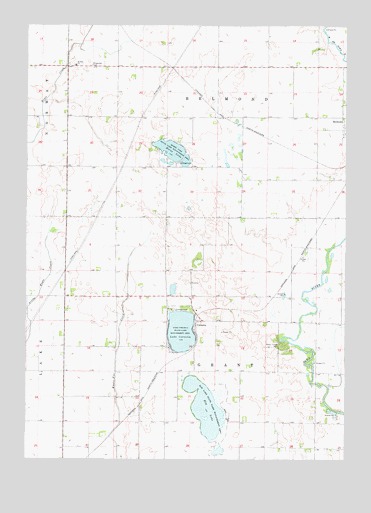
Cornelia, IA USGS Topographic Map
Click on map above to begin viewing in our Map Viewer.

This topographic map contains these locations and features:
Feature Name Type Latitude Longitude GNIS ID View Map
Cambier River Bend AreaParkN42.8000°W93.6391°1944385View Map
CorneliaLocaleN42.7900°W93.6833°1944482View Map
CorneliaPopulated PlaceN42.7900°W93.6833°455630View Map
Cornelia Lake BridgeBridgeN42.7916°W93.6849°1944375View Map
Cornelia Post Office (historical)Post OfficeN42.7916°W93.6849°1944405View Map
Dayspring Assembly of God ChurchChurchN42.8444°W93.6258°1944535View Map
Elm LakeLakeN42.7648°W93.6799°456338View Map
Elm Lake Wildlife Management AreaParkN42.7650°W93.6774°456339View Map
Lake CorneliaLakeN42.7869°W93.6893°455631View Map
Lake Cornelia State Game Management AreaParkN42.7886°W93.6894°458183View Map
Lower Morse Lake Waterfowl Production AreaParkN42.8055°W93.6697°1944386View Map
Morse LakeLakeN42.8393°W93.6939°459252View Map
Morse Lake Wildlife Management AreaParkN42.8389°W93.6919°459253View Map
Pikes Timber ParkParkN42.7830°W93.6485°460141View Map
Ringsaker CemeteryCemeteryN42.8635°W93.7248°460639View Map
Rolling Acres PotholesParkN42.8375°W93.6738°1944380View Map
Saint Olaf ChurchChurchN42.8636°W93.7313°461234View Map
Saint Olaf Lutheran ChurchChurchN42.8636°W93.7316°1944483View Map
Township of BelmondCivilN42.8641°W93.6756°467435View Map
Township of GrantCivilN42.7757°W93.6760°467961View Map
Wright County Waterfowl Production AreaParkN42.8194°W93.6773°2765566View Map

Note: Coordinates in the location and feature list above are referenced to NAD83 datum.


Copyright (C) 2008-2024 Ryan Niemi / Sunset Dynamics ... All Rights Reserved