TopoQuest Logo
Do you find TopoQuest useful?
Help keep TopoQuest running and adding new maps/features by donating!
Bitcoin:  19c7KJd3qBynnjoSw5npx9KScwjBe4ifkT
Litecoin:  LXs6TkuXGGXo1vDsWCkWVdjQX94eUKd6ui
Home View Maps Find Maps Find Places Resources & Links


Corrigan, Texas Topographic Map

USGS Map Title: Corrigan, TX
USGS Map MRC: 30094H7
DRG (GeoTIFF) Download: o30094h7.tif


Neighboring USGS Topographic Map Quads:


  Trevat, TX  
31094A8
 

  Wakefield, TX  
31094A7
 

  Pluck, TX  
31094A6
 

  Carmona, TX  
30094H8
 

  Corrigan, TX  
30094H7
 

  Camden, TX  
30094H6
 

  New Willard, TX  
30094G8
 

  Leggett, TX  
30094G7
 

  Hortense, TX  
30094G6


Map MRC Location:

N31°
W95°
N31°
W94°
H8 H7 H6 H5 H4 H3 H2 H1
G8 G7 G6 G5 G4 G3 G2 G1
F8 F7 F6 F5 F4 F3 F2 F1
E8 E7 E6 E5 E4 E3 E2 E1
D8 D7 D6 D5 D4 D3 D2 D1
C8 C7 C6 C5 C4 C3 C2 C1
B8 B7 B6 B5 B4 B3 B2 B1
A8 A7 A6 A5 A4 A3 A2 A1
N30°
W95°
N30°
W94°

Corrigan, TX USGS 1:24K Topographic Map Preview:
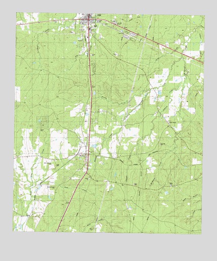
Corrigan, TX USGS Topographic Map
Click on map above to begin viewing in our Map Viewer.

This topographic map contains these locations and features:
Feature Name Type Latitude Longitude GNIS ID View Map
AsiaPopulated PlaceN30.9982°W94.8694°2034867View Map
Beaver CreekStreamN30.9971°W94.7513°1351726View Map
BeringPopulated PlaceN30.8835°W94.8641°1379409View Map
Brushy CreekStreamN30.9571°W94.7849°1353036View Map
Bundix BranchStreamN30.9269°W94.7924°1353306View Map
Burch CemeteryCemeteryN30.9310°W94.8572°1353314View Map
CorriganPopulated PlaceN30.9969°W94.8272°1355032View Map
Corrigan - Camden High SchoolSchoolN30.9935°W94.8274°2008078View Map
Corrigan - Camden Junior High SchoolSchoolN30.9930°W94.8255°2008079View Map
Corrigan City OfficeBuildingN30.9991°W94.8279°2753762View Map
Corrigan Police DepartmentBuildingN30.9985°W94.8265°2751209View Map
Johnson CreekStreamN30.9655°W94.7630°1360327View Map
Jones CreekStreamN30.9849°W94.7616°1360390View Map
Kennedy CreekStreamN30.9760°W94.7644°1374358View Map
MoscowPopulated PlaceN30.9132°W94.8252°1363185View Map
Moscow Post OfficePost OfficeN30.9138°W94.8266°2732160View Map
Rock IslandLocaleN30.9452°W94.7791°1366680View Map
Sand CreekStreamN30.8996°W94.8635°1367578View Map
Snow HillPopulated PlaceN30.9938°W94.8091°1380568View Map
Sulphur CreekStreamN30.9807°W94.7613°1369357View Map
Timber LakeReservoirN30.9469°W94.8219°1861967View Map
Timber Lake DamDamN30.9469°W94.8219°1861966View Map
Town of CorriganCivilN30.9988°W94.8275°2413246View Map

Note: Coordinates in the location and feature list above are referenced to NAD83 datum.


Copyright (C) 2008-2024 Ryan Niemi / Sunset Dynamics ... All Rights Reserved