TopoQuest Logo
Do you find TopoQuest useful?
Help keep TopoQuest running and adding new maps/features by donating!
Bitcoin:  19c7KJd3qBynnjoSw5npx9KScwjBe4ifkT
Litecoin:  LXs6TkuXGGXo1vDsWCkWVdjQX94eUKd6ui
Home View Maps Find Maps Find Places Resources & Links


Cosio Knob, California Topographic Map

USGS Map Title: Cosio Knob, CA
USGS Map MRC: 36121A2
DRG (GeoTIFF) Download: o36121a2.tif


Neighboring USGS Topographic Map Quads:


  Reliz Canyon, CA  
36121B3
 

  Thompson Canyon, CA  
36121B2
 

  San Lucas, CA  
36121B1
 

  Bear Canyon, CA  
36121A3
 

  Cosio Knob, CA  
36121A2
 

  Espinosa Canyon, CA  
36121A1
 

  Alder Peak, CA  
35121H3
 

  Jolon, CA  
35121H2
 

  Williams Hill, CA  
35121H1


Map MRC Location:

N37°
W122°
N37°
W121°
H8 H7 H6 H5 H4 H3 H2 H1
G8 G7 G6 G5 G4 G3 G2 G1
F8 F7 F6 F5 F4 F3 F2 F1
E8 E7 E6 E5 E4 E3 E2 E1
D8 D7 D6 D5 D4 D3 D2 D1
C8 C7 C6 C5 C4 C3 C2 C1
B8 B7 B6 B5 B4 B3 B2 B1
A8 A7 A6 A5 A4 A3 A2 A1
N36°
W122°
N36°
W121°

Cosio Knob, CA USGS 1:24K Topographic Map Preview:
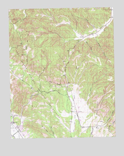
Cosio Knob, CA USGS Topographic Map
Click on map above to begin viewing in our Map Viewer.

This topographic map contains these locations and features:
Feature Name Type Latitude Longitude GNIS ID View Map
Argyle School (historical)SchoolN36.0244°W121.1716°1670117View Map
Cosio KnobSummitN36.0797°W121.2344°240955View Map
Crazy CanyonValleyN36.0936°W121.1616°241080View Map
Engineer DamDamN36.0083°W121.2410°1664565View Map
Fort Hunter Liggett Fire DepartmentBuildingN36.0110°W121.2419°2623887View Map
Hunter-LiggettPopulated PlaceN36.0102°W121.2385°252404View Map
Jolon ValleyValleyN36.0039°W121.1752°244126View Map
Kirk CanyonValleyN36.0508°W121.1741°244333View Map
Mansfield CanyonValleyN36.0986°W121.1458°245450View Map
Mission San Antonia de PaduaChurchN36.0152°W121.2499°248789View Map
Oat Hill Reservoir DamDamN36.0200°W121.2027°1664564View Map
Oat HillsRidgeN36.0972°W121.2296°246787View Map
Old Man CanyonValleyN36.0011°W121.1994°246849View Map
Pole CanyonValleyN36.0225°W121.1716°247663View Map
Robinson CanyonValleyN36.0102°W121.1480°248270View Map
Sulphur Spring CanyonValleyN36.0075°W121.2416°250061View Map
Wilkins CanyonValleyN36.1033°W121.1460°251577View Map

Note: Coordinates in the location and feature list above are referenced to NAD83 datum.


Copyright (C) 2008-2025 Ryan Niemi / Sunset Dynamics ... All Rights Reserved