TopoQuest Logo
Do you find TopoQuest useful?
Help keep TopoQuest running and adding new maps/features by donating!
Bitcoin:  19c7KJd3qBynnjoSw5npx9KScwjBe4ifkT
Litecoin:  LXs6TkuXGGXo1vDsWCkWVdjQX94eUKd6ui
Home View Maps Find Maps Find Places Resources & Links


Cove Point, Maryland Topographic Map

USGS Map Title: Cove Point, MD
USGS Map MRC: 38076D4
DRG (GeoTIFF) Download: o38076d4.tif


Neighboring USGS Topographic Map Quads:


  Prince Frederick, MD  
38076E5


  Broomes Island, MD  
38076D5
 

  Cove Point, MD  
38076D4


  Hollywood, MD  
38076C5
 

  Solomons Island, MD  
38076C4


Map MRC Location:

N39°
W77°
N39°
W76°
H8 H7 H6 H5 H4 H3 H2 H1
G8 G7 G6 G5 G4 G3 G2 G1
F8 F7 F6 F5 F4 F3 F2 F1
E8 E7 E6 E5 E4 E3 E2 E1
D8 D7 D6 D5 D4 D3 D2 D1
C8 C7 C6 C5 C4 C3 C2 C1
B8 B7 B6 B5 B4 B3 B2 B1
A8 A7 A6 A5 A4 A3 A2 A1
N38°
W77°
N38°
W76°

Cove Point, MD USGS 1:24K Topographic Map Preview:
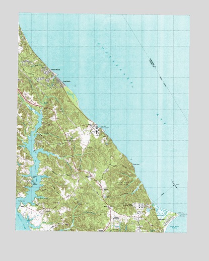
Cove Point, MD USGS Topographic Map
Click on map above to begin viewing in our Map Viewer.

This topographic map contains these locations and features:
Feature Name Type Latitude Longitude GNIS ID View Map
Appeal SchoolSchoolN38.3757°W76.4369°1676539View Map
Bay Breeze Girl Scout CampLocaleN38.4082°W76.4138°1676542View Map
BerthaPopulated PlaceN38.3907°W76.4330°589740View Map
Breedens PointCapeN38.4068°W76.4833°583365View Map
BrianwoodPopulated PlaceN38.3757°W76.4066°1676544View Map
Brooms IslandIslandN38.4232°W76.4911°1676546View Map
Calvary Bible ChurchChurchN38.4271°W76.4625°1676554View Map
Calvert BeachPopulated PlaceN38.4660°W76.4772°589877View Map
Calvert Beach Census Designated PlaceCensusN38.4728°W76.4897°2629791View Map
Calvert Beach EstatesPopulated PlaceN38.4621°W76.4833°1676548View Map
Calvert Beach ParkPopulated PlaceN38.4721°W76.4941°1676549View Map
Calvert Beach RunStreamN38.4640°W76.4708°583552View Map
Calvert Beach-Long Beach Census Designated Place (historical)CensusN38.4621°W76.4791°2389268View Map
Calvert Cliffs Nuclear PowerplantLocaleN38.4347°W76.4417°1676551View Map
Calvert Cliffs State ParkParkN38.4029°W76.4219°1676552View Map
Calvert County Public Library Library - Southern BranchBuildingN38.3808°W76.4368°2503147View Map
Camp ConoyLocaleN38.4285°W76.4352°583560View Map
Cape LeonardPopulated PlaceN38.4021°W76.4919°1676555View Map
Cheasapeake Hills Golf ClubLocaleN38.3819°W76.4270°2503182View Map
Chesapeake Country ClubLocaleN38.3829°W76.4288°1676558View Map
Chesapeake Cove EstatesPopulated PlaceN38.3768°W76.4155°1676559View Map
Clng Cove Point HeliportAirportN38.3918°W76.4080°595319View Map
Columbia Lng Secondary DamDamN38.3901°W76.4163°594553View Map
Cove CampLocaleN38.4204°W76.4927°588920View Map
Cove of CalvertPopulated PlaceN38.3760°W76.3927°1676568View Map
Cove PointPopulated PlaceN38.3812°W76.3888°590030View Map
Cove PointCapeN38.3846°W76.3811°583920View Map
Cove Point BeachBeachN38.3812°W76.3872°1676571View Map
Cove Point HollowBayN38.3771°W76.3849°583921View Map
Cove Point LighthouseLocaleN38.3862°W76.3819°1676572View Map
Cove Point MarshSwampN38.3869°W76.3947°583922View Map
Cove Point ParkParkN38.3862°W76.4191°1676569View Map
Cove Point WoodsPopulated PlaceN38.3793°W76.4041°1676570View Map
District 1, Solomons IslandCivilN38.4013°W76.4433°1929426View Map
Duncans PondLakeN38.4523°W76.4594°1955746View Map
Egypt CoveBayN38.4232°W76.4933°584260View Map
Flag HarborPopulated PlaceN38.4646°W76.4747°1676579View Map
Flag PondsLakeN38.4523°W76.4594°584408View Map
Flag Ponds Nature ParkParkN38.4510°W76.4630°1955743View Map
Flag Ponds ParkParkN38.4529°W76.4597°1676580View Map
Fort HillSummitN38.4357°W76.4780°1676581View Map
Goldstein BranchStreamN38.4190°W76.4572°584635View Map
Grapevine CoveBayN38.3940°W76.4830°1676583View Map
Grays CreekStreamN38.4032°W76.4074°584708View Map
Grover CreekStreamN38.4057°W76.4133°584783View Map
Grovers CreekStreamN38.4293°W76.4913°584784View Map
Johns CreekStreamN38.4190°W76.4855°585248View Map
Kings CreekStreamN38.4698°W76.4786°585314View Map
Laveel BranchStreamN38.4187°W76.4561°585375View Map
Long BeachPopulated PlaceN38.4610°W76.4688°590694View Map
Long Beach Census Designated PlaceCensusN38.4568°W76.4736°2629798View Map
LusbyPopulated PlaceN38.4107°W76.4552°590708View Map
Lusby Post OfficePost OfficeN38.3754°W76.4343°1676591View Map
Mears CoveBayN38.3810°W76.4911°585784View Map
Mears CreekStreamN38.3798°W76.4913°585785View Map
Middleham and Saint Peters Episcopal Day SchoolSchoolN38.3988°W76.4371°2132485View Map
Middleham CemeteryCemeteryN38.3994°W76.4362°1676592View Map
Middleham ChapelChurchN38.3987°W76.4361°585825View Map
Mosley AcresPopulated PlaceN38.3965°W76.4575°1676593View Map
Mosley BranchStreamN38.4168°W76.4661°585970View Map
Norris Cove CampLocaleN38.4218°W76.4936°1676594View Map
Nutts CliffsCliffN38.3843°W76.4955°1676595View Map
Osborn CoveBayN38.4012°W76.4808°2710669View Map
PapasPopulated PlaceN38.3826°W76.4102°1676602View Map
Patuxent Elementary SchoolSchoolN38.3760°W76.4358°2131941View Map
Perrin BranchStreamN38.4423°W76.4816°586472View Map
Planters WharfPopulated PlaceN38.4271°W76.4858°588863View Map
Planters Wharf (historical)LocaleN38.4282°W76.4875°1676605View Map
Planters Wharf CreekStreamN38.4287°W76.4872°586585View Map
Quakers SwampStreamN38.4476°W76.4808°586741View Map
Richardsons PondLakeN38.4546°W76.4632°1955744View Map
Rocky PointCapeN38.4140°W76.4152°588810View Map
Rodney PointCapeN38.3904°W76.4958°586914View Map
Rollins CoveBayN38.4062°W76.4788°586922View Map
Saint Johns ChurchChurchN38.3910°W76.4680°587038View Map
Saint Johns Methodist CemeteryCemeteryN38.3903°W76.4688°1676609View Map
Saint Leonard (historical)Populated PlaceN38.4473°W76.4872°1676612View Map
Saint Leonard Census Designated PlaceCensusN38.4658°W76.4972°2390348View Map
Saint Leonard CreekStreamN38.3901°W76.4988°587061View Map
Saint Leonard Elementary SchoolSchoolN38.4629°W76.4990°2132494View Map
Saint Leonard ShoresPopulated PlaceN38.4371°W76.4905°1676613View Map
Saint Paul BranchStreamN38.3823°W76.4575°587118View Map
Saint Paul United Methodist CemeteryCemeteryN38.3889°W76.4306°1676614View Map
Saint Pauls ChurchChurchN38.3887°W76.4308°587125View Map
Saw Pit CoveBayN38.3904°W76.4875°587231View Map
SollersPopulated PlaceN38.3885°W76.4925°591312View Map
Solomons Volunteer Rescue Squad and Fire Department Company 3 SubstationBuildingN38.3775°W76.4087°2131777View Map
Southern SchoolSchoolN38.4065°W76.4461°1676625View Map
Thomas BranchStreamN38.4065°W76.4108°587764View Map
Todds PondLakeN38.4500°W76.4566°1955745View Map
Walnut CovePopulated PlaceN38.4437°W76.4752°1676632View Map
Webster PondsLakeN38.3854°W76.3905°588101View Map
Western Shore EstatesPopulated PlaceN38.4862°W76.4972°1676633View Map
White SandsPopulated PlaceN38.4246°W76.4758°1676634View Map
Wilbur PondLakeN38.3911°W76.3984°588241View Map
Woodland BranchStreamN38.4518°W76.4786°588325View Map

Note: Coordinates in the location and feature list above are referenced to NAD83 datum.


Copyright (C) 2008-2024 Ryan Niemi / Sunset Dynamics ... All Rights Reserved