TopoQuest Logo
Do you find TopoQuest useful?
Help keep TopoQuest running and adding new maps/features by donating!
Bitcoin:  19c7KJd3qBynnjoSw5npx9KScwjBe4ifkT
Litecoin:  LXs6TkuXGGXo1vDsWCkWVdjQX94eUKd6ui
Home View Maps Find Maps Find Places Resources & Links


Acme, Wyoming Topographic Map

USGS Map Title: Acme, WY
USGS Map MRC: 44106H8
DRG (GeoTIFF) Download: o44106h8.tif


Neighboring USGS Topographic Map Quads:


  Bar V Ranch, MT  
45107A1
 

  Pearl School, MT  
45106A8
 

  Decker, MT  
45106A7
 

  Monarch, WY  
44107H1
 

  Acme, WY  
44106H8
 

  Bar N Draw, WY  
44106H7
 

  Hultz Draw, WY  
44107G1
 

  Sheridan, WY  
44106G8
 

  Wyarno, WY  
44106G7


Map MRC Location:

N45°
W107°
N45°
W106°
H8 H7 H6 H5 H4 H3 H2 H1
G8 G7 G6 G5 G4 G3 G2 G1
F8 F7 F6 F5 F4 F3 F2 F1
E8 E7 E6 E5 E4 E3 E2 E1
D8 D7 D6 D5 D4 D3 D2 D1
C8 C7 C6 C5 C4 C3 C2 C1
B8 B7 B6 B5 B4 B3 B2 B1
A8 A7 A6 A5 A4 A3 A2 A1
N44°
W107°
N44°
W106°

Acme, WY USGS 1:24K Topographic Map Preview:
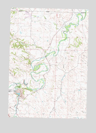
Acme, WY USGS Topographic Map
Click on map above to begin viewing in our Map Viewer.

This topographic map contains these locations and features:
Feature Name Type Latitude Longitude GNIS ID View Map
09S39E32CDAD01 WellWellN44.9991°W106.9809°807268View Map
09S39E33DDCC01 WellWellN44.9966°W106.9517°807262View Map
09S39E33DDCC02 WellWellN44.9966°W106.9545°807264View Map
09S39E33DDCD01 WellWellN44.9966°W106.9528°807263View Map
09S39E33DDDD01 WellWellN44.9966°W106.9509°807261View Map
09S39E34CCCC01 WellWellN44.9966°W106.9498°807260View Map
09S39E34CDCD01 WellWellN44.9969°W106.9434°807265View Map
58N84W23ABBC01 WellWellN44.9955°W106.9562°807258View Map
58N84W23BBCB01 WellWellN44.9939°W106.9651°807256View Map
58N84W23BBCB02 WellWellN44.9939°W106.9651°807257View Map
AcmePopulated PlaceN44.9105°W106.9851°1584695View Map
Acme Number Forty-two MineMineN44.9130°W106.9842°1704196View Map
Acme Number Two MineMineN44.9075°W106.9920°1704195View Map
Ash CreekStreamN44.9483°W106.9372°1584964View Map
Beatty GulchValleyN44.9503°W106.9151°1585296View Map
Big Horn MineMineN44.9133°W106.9770°1704198View Map
Big Horn Number One MineMineN44.9041°W106.9828°1704199View Map
Bighorn MineMineN44.9453°W106.9367°1704197View Map
Dietz Number Five and Eight MineMineN44.8861°W106.9770°1704200View Map
Evans MineMineN44.9414°W106.9603°1704201View Map
Gladewater DitchCanalN44.9864°W106.9067°1588926View Map
Gladewater DitchCanalN44.9975°W106.8912°771792View Map
Goose CreekStreamN44.9119°W106.9798°1584657View Map
Hidden Water CreekStreamN44.9133°W106.9865°1589529View Map
Hotchkiss Number Two MineMineN44.8958°W106.9953°1704206View Map
Little Youngs CreekStreamN44.9914°W106.9514°773506View Map
New Acme MineMineN44.8997°W106.9784°1704202View Map
PSO Number One MineMineN44.9900°W106.9720°1704194View Map
Roland MineMineN44.8930°W106.9445°1704203View Map
Tongue River Stone Company MineMineN44.9005°W106.9812°1704207View Map
Welch Number One North MineMineN44.9425°W106.9590°1704210View Map
Welch Number One South MineMineN44.9425°W106.9590°1704212View Map
Welch Number Two MineMineN44.9425°W106.9590°1704211View Map
West Branch Little Youngs CreekStreamN44.9916°W106.9673°1596996View Map
Whitney MineMineN44.9458°W106.9159°1704208View Map
Youngs CreekStreamN44.9692°W106.9106°778749View Map
Youngs Creek MineMineN44.9925°W106.9784°1704209View Map
Zowada Pit and Plachet Pit MineMineN44.8997°W106.9784°1704205View Map

Note: Coordinates in the location and feature list above are referenced to NAD83 datum.


Copyright (C) 2008-2025 Ryan Niemi / Sunset Dynamics ... All Rights Reserved