TopoQuest Logo
Do you find TopoQuest useful?
Help keep TopoQuest running and adding new maps/features by donating!
Bitcoin:  19c7KJd3qBynnjoSw5npx9KScwjBe4ifkT
Litecoin:  LXs6TkuXGGXo1vDsWCkWVdjQX94eUKd6ui
Home View Maps Find Maps Find Places Resources & Links


Coyote Buttes, Arizona Topographic Map

USGS Map Title: Coyote Buttes, AZ
USGS Map MRC: 36112H1
DRG (GeoTIFF) Download: o36112h1.tif


Neighboring USGS Topographic Map Quads:


  Petrified Hollow, UT  
37112A2
 

  Pine Hollow Canyon, UT  
37112A1
 

  West Clark Bench, UT  
37111A8
 

  Buck Pasture Canyon, AZ  
36112H2
 

  Coyote Buttes, AZ  
36112H1
 

  Poverty Flat, AZ  
36111H8
 

  Cooper Ridge, AZ  
36112G2
 

  House Rock Spring, AZ  
36112G1
 

  One Toe Ridge, AZ  
36111G8


Map MRC Location:

N37°
W113°
N37°
W112°
H8 H7 H6 H5 H4 H3 H2 H1
G8 G7 G6 G5 G4 G3 G2 G1
F8 F7 F6 F5 F4 F3 F2 F1
E8 E7 E6 E5 E4 E3 E2 E1
D8 D7 D6 D5 D4 D3 D2 D1
C8 C7 C6 C5 C4 C3 C2 C1
B8 B7 B6 B5 B4 B3 B2 B1
A8 A7 A6 A5 A4 A3 A2 A1
N36°
W113°
N36°
W112°

Coyote Buttes, AZ USGS 1:24K Topographic Map Preview:
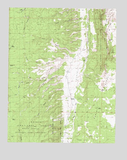
Coyote Buttes, AZ USGS Topographic Map
Click on map above to begin viewing in our Map Viewer.

This topographic map contains these locations and features:
Feature Name Type Latitude Longitude GNIS ID View Map
Basin CanyonValleyN36.9517°W112.0613°24115View Map
Buckskin MountainSummitN36.9758°W112.1044°2113View Map
Corral ValleyValleyN36.8775°W112.0383°27981View Map
Coyote ButtesSummitN36.9678°W112.0113°3474View Map
Coyote SpringSpringN36.9519°W112.0359°3503View Map
Dannys ArchArchN36.9908°W112.0053°2581888View Map
Dead Man CanyonValleyN36.9342°W112.0993°24246View Map
Fence CanyonValleyN36.9244°W112.0621°24057View Map
Joannes ArchArchN36.9908°W112.0056°2581887View Map
Ladder ReservoirReservoirN36.9073°W112.0212°24067View Map
Larkum CanyonValleyN36.9583°W112.0468°24068View Map
Leach ReservoirReservoirN36.9044°W112.1197°2091664View Map
Lone Tree ReservoirReservoirN36.9157°W112.0486°24070View Map
Long CanyonValleyN36.9367°W112.0630°24101View Map
Maries ReservoirReservoirN36.9978°W112.1096°24207View Map
Middle ReservoirReservoirN36.9637°W112.1221°24074View Map
North Burro TankReservoirN36.8828°W112.1114°2091665View Map
North Larkum CanyonValleyN36.9903°W112.0430°24083View Map
Paw HoleReservoirN36.9244°W112.0174°24085View Map
Press TankReservoirN36.9033°W112.0486°20966View Map
Red CanyonValleyN36.9494°W112.0532°24087View Map
Sand CoveValleyN36.9944°W112.0102°24090View Map
Shearing Corral ReservoirReservoirN36.9478°W112.1230°24094View Map
The BasinBasinN36.9522°W112.1052°24114View Map
Top RockSummitN36.9889°W112.0042°2091662View Map
Top Rock SpringSpringN36.9878°W112.0083°2091663View Map
Twin SinksBasinN36.9922°W112.1042°2091660View Map

Note: Coordinates in the location and feature list above are referenced to NAD83 datum.


Copyright (C) 2008-2024 Ryan Niemi / Sunset Dynamics ... All Rights Reserved