TopoQuest Logo
Do you find TopoQuest useful?
Help keep TopoQuest running and adding new maps/features by donating!
Bitcoin:  19c7KJd3qBynnjoSw5npx9KScwjBe4ifkT
Litecoin:  LXs6TkuXGGXo1vDsWCkWVdjQX94eUKd6ui
Home View Maps Find Maps Find Places Resources & Links


Angostura Reservoir, South Dakota Topographic Map

USGS Map Title: Angostura Reservoir, SD
USGS Map MRC: 43103C4
DRG (GeoTIFF) Download: o43103c4.tif


Neighboring USGS Topographic Map Quads:


  Minnekahta NE, SD  
43103D5
 

  Hot Springs, SD  
43103D4
 

  Buffalo Gap, SD  
43103D3
 

  Cascade Springs, SD  
43103C5
 

  Angostura Reservoir, SD  
43103C4
 

  Hot Springs SE, SD  
43103C3
 

  Heppner, SD  
43103B5


Map MRC Location:

N44°
W104°
N44°
W103°
H8 H7 H6 H5 H4 H3 H2 H1
G8 G7 G6 G5 G4 G3 G2 G1
F8 F7 F6 F5 F4 F3 F2 F1
E8 E7 E6 E5 E4 E3 E2 E1
D8 D7 D6 D5 D4 D3 D2 D1
C8 C7 C6 C5 C4 C3 C2 C1
B8 B7 B6 B5 B4 B3 B2 B1
A8 A7 A6 A5 A4 A3 A2 A1
N43°
W104°
N43°
W103°

Angostura Reservoir, SD USGS 1:24K Topographic Map Preview:
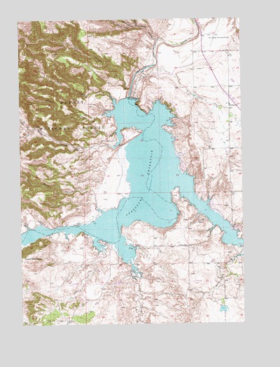
Angostura Reservoir, SD USGS Topographic Map
Click on map above to begin viewing in our Map Viewer.

This topographic map contains these locations and features:
Feature Name Type Latitude Longitude GNIS ID View Map
Adams CanyonValleyN43.3358°W103.4506°1261180View Map
Angostura DamDamN43.3433°W103.4383°1261190View Map
Angostura ReservoirReservoirN43.3058°W103.4343°1261191View Map
Angostura Reservoir State Recreation AreaParkN43.2908°W103.4796°1263123View Map
Bailey Pond Number 1 DamDamN43.2633°W103.4438°1262845View Map
Coleman SchoolSchoolN43.3397°W103.3819°1261474View Map
Dry CreekStreamN43.2764°W103.4396°1261581View Map
Fall River FeedyardLocaleN43.3531°W103.3772°2576415View Map
Green CanyonValleyN43.3043°W103.4590°1261740View Map
Horse Camp DrawValleyN43.3544°W103.4296°1261837View Map
Horsehead CreekStreamN43.3089°W103.4091°1261842View Map
Hot Springs Municipal AirportAirportN43.3687°W103.3917°1262824View Map
Knapple CanyonValleyN43.3673°W103.4216°1261920View Map
Lithia (historical)LocaleN43.3416°W103.4219°1264605View Map
Lithia Post Office (historical)Post OfficeN43.2991°W103.4049°1267150View Map
Lithia SchoolSchoolN43.2819°W103.4116°1261963View Map
Maitland (historical)LocaleN43.2522°W103.4719°1264604View Map
Middle Knappie CanyonValleyN43.3719°W103.4343°1262069View Map
North Knappie CanyonValleyN43.3718°W103.4341°1262150View Map
Peterspuddle DamDamN43.2566°W103.3871°1262789View Map
Red CanyonValleyN43.3398°W103.4459°1262268View Map
Sheps CanyonValleyN43.3301°W103.4445°1262401View Map
South Knappie CanyonValleyN43.3718°W103.4349°1262469View Map
Tepee CreekStreamN43.2850°W103.4583°1262564View Map
Tepee MountainSummitN43.2776°W103.4999°1262566View Map
Township of LithiaCivilN43.2528°W103.3963°1268774View Map
Wall CanyonValleyN43.3467°W103.4377°1262654View Map
Willow CreekStreamN43.2778°W103.3755°1262724View Map

Note: Coordinates in the location and feature list above are referenced to NAD83 datum.


Copyright (C) 2008-2024 Ryan Niemi / Sunset Dynamics ... All Rights Reserved