TopoQuest Logo
Do you find TopoQuest useful?
Help keep TopoQuest running and adding new maps/features by donating!
Bitcoin:  19c7KJd3qBynnjoSw5npx9KScwjBe4ifkT
Litecoin:  LXs6TkuXGGXo1vDsWCkWVdjQX94eUKd6ui
Home View Maps Find Maps Find Places Resources & Links


Acoma Pueblo, New Mexico Topographic Map

USGS Map Title: Acoma Pueblo, NM
USGS Map MRC: 34107H5
DRG (GeoTIFF) Download: o34107h5.tif


Neighboring USGS Topographic Map Quads:


  McCartys, NM  
35107A6
 

  Cubero, NM  
35107A5
 

  Laguna, NM  
35107A4
 

  Crow Point, NM  
34107H6
 

  Acoma Pueblo, NM  
34107H5
 

  South Butte, NM  
34107H4
 

  Blue Mesa, NM  
34107G6
 

  East Mesa, NM  
34107G5
 

  Marmon Ranch, NM  
34107G4


Map MRC Location:

N35°
W108°
N35°
W107°
H8 H7 H6 H5 H4 H3 H2 H1
G8 G7 G6 G5 G4 G3 G2 G1
F8 F7 F6 F5 F4 F3 F2 F1
E8 E7 E6 E5 E4 E3 E2 E1
D8 D7 D6 D5 D4 D3 D2 D1
C8 C7 C6 C5 C4 C3 C2 C1
B8 B7 B6 B5 B4 B3 B2 B1
A8 A7 A6 A5 A4 A3 A2 A1
N34°
W108°
N34°
W107°

Acoma Pueblo, NM USGS 1:24K Topographic Map Preview:
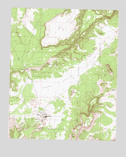
Acoma Pueblo, NM USGS Topographic Map
Click on map above to begin viewing in our Map Viewer.

This topographic map contains these locations and features:
Feature Name Type Latitude Longitude GNIS ID View Map
Acoma Community Library Resource CenterBuildingN34.8987°W107.5870°929293View Map
Acoma MuseumBuildingN34.8964°W107.5817°929474View Map
Acoma PuebloPopulated PlaceN34.8964°W107.5817°928675View Map
Acoma RockSummitN34.8906°W107.5831°898617View Map
Acoma SpringsSpringN34.9327°W107.6048°885548View Map
Acoma ValleyValleyN34.9653°W107.5175°902982View Map
Acoma VillagePopulated PlaceN34.8987°W107.5870°885549View Map
Acomita PitMineN34.9609°W107.5162°916896View Map
Balo DepositMineN34.9178°W107.5100°916425View Map
Caņada de CruzValleyN34.9717°W107.5809°885470View Map
Cebolleta Historical MarkerParkN34.8964°W107.5817°932283View Map
Deadmans RockPillarN34.9412°W107.6087°888248View Map
Dinosaur RockSummitN34.8981°W107.5889°898651View Map
Dripping SpringsSpringN34.9239°W107.5060°888521View Map
Eye of the MoonArchN34.9228°W107.6153°2632192View Map
Flour ButteSummitN34.9773°W107.5212°898655View Map
Jar ButteSummitN34.9409°W107.5084°890414View Map
Laguna 6 Water WellWellN34.9659°W107.5142°918509View Map
Limestone QuarryMineN34.9609°W107.5162°917879View Map
Mesa EncantadaSummitN34.9212°W107.5512°928760View Map
Pueblo of Acoma Historical MarkerParkN34.8964°W107.5817°931693View Map
Rabbit ButteSummitN34.9623°W107.5262°898691View Map
San Estevan de Acoma Mission Church Historic SiteChurchN34.8964°W107.5811°935210View Map
Sand CanyonValleyN34.8912°W107.5020°894497View Map
Seama MesaSummitN34.9995°W107.5053°894681View Map
Sky City CommunitySchoolN34.8964°W107.5817°925118View Map
Woods MesaSummitN34.9634°W107.5570°896760View Map

Note: Coordinates in the location and feature list above are referenced to NAD83 datum.


Copyright (C) 2008-2025 Ryan Niemi / Sunset Dynamics ... All Rights Reserved