TopoQuest Logo
Do you find TopoQuest useful?
Help keep TopoQuest running and adding new maps/features by donating!
Bitcoin:  19c7KJd3qBynnjoSw5npx9KScwjBe4ifkT
Litecoin:  LXs6TkuXGGXo1vDsWCkWVdjQX94eUKd6ui
Home View Maps Find Maps Find Places Resources & Links


Cromwell, Oklahoma Topographic Map

USGS Map Title: Cromwell, OK
USGS Map MRC: 35096C4
DRG (GeoTIFF) Download: o35096c4.tif


Neighboring USGS Topographic Map Quads:


  Prague NE, OK  
35096D5
 

  Boley, OK  
35096D4
 

  Okemah, OK  
35096D3
 

  Prague SE, OK  
35096C5
 

  Cromwell, OK  
35096C4
 

  Okemah SE, OK  
35096C3
 

  Wewoka West, OK  
35096B5
 

  Wewoka East, OK  
35096B4
 

  Yeager, OK  
35096B3


Map MRC Location:

N36°
W97°
N36°
W96°
H8 H7 H6 H5 H4 H3 H2 H1
G8 G7 G6 G5 G4 G3 G2 G1
F8 F7 F6 F5 F4 F3 F2 F1
E8 E7 E6 E5 E4 E3 E2 E1
D8 D7 D6 D5 D4 D3 D2 D1
C8 C7 C6 C5 C4 C3 C2 C1
B8 B7 B6 B5 B4 B3 B2 B1
A8 A7 A6 A5 A4 A3 A2 A1
N35°
W97°
N35°
W96°

Cromwell, OK USGS 1:24K Topographic Map Preview:
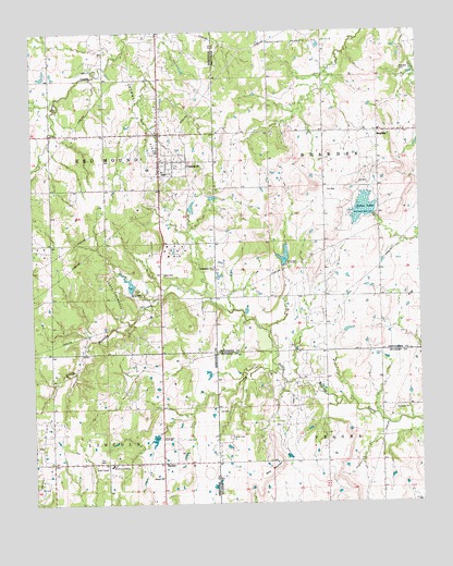
Cromwell, OK USGS Topographic Map
Click on map above to begin viewing in our Map Viewer.

This topographic map contains these locations and features:
Feature Name Type Latitude Longitude GNIS ID View Map
Bald MountainSummitN35.2604°W96.4214°1089813View Map
BeardenPopulated PlaceN35.3481°W96.3886°1100197View Map
Bearden CemeteryCemeteryN35.3647°W96.3814°2710137View Map
Bearden Elementary SchoolSchoolN35.3488°W96.3877°1803486View Map
Bearden Fire DepartmentBuildingN35.3485°W96.3810°2657151View Map
ButnerPopulated PlaceN35.2609°W96.4589°1100253View Map
Butner CemeteryCemeteryN35.2642°W96.4586°2712374View Map
Butner CemeteryCemeteryN35.2679°W96.4372°1090753View Map
Butner ChurchChurchN35.2573°W96.4595°1090754View Map
Butner Elementary SchoolSchoolN35.3376°W96.4578°1790615View Map
Butner High SchoolSchoolN35.3376°W96.4578°1790310View Map
Cohee LakeReservoirN35.3282°W96.3931°1091544View Map
Cohee Lake DamDamN35.3267°W96.3903°1751302View Map
Creek/Seminole Joint-Use Oklahoma Tribal Statistical AreaCensusN35.2870°W96.4657°1925072View Map
CromwellPopulated PlaceN35.3401°W96.4572°1091830View Map
Cromwell Oil FieldOilfieldN35.3642°W96.4670°1091831View Map
Cromwell Volunteer Fire DepartmentBuildingN35.3454°W96.4587°2656830View Map
Little Quarsarty CemeteryCemeteryN35.3153°W96.4436°2712378View Map
Little Wewoka Creek Site 5 DamDamN35.2851°W96.4253°1750920View Map
Little Wewoka Creek Site 5 ReservoirReservoirN35.2851°W96.4253°1750921View Map
Little Wewoka Creek Site 6 DamDamN35.3134°W96.4186°1752057View Map
Little Wewoka Creek Site 6 ReservoirReservoirN35.3134°W96.4186°1752058View Map
Little Wewoka Site 1 DamDamN35.3067°W96.4686°1757039View Map
Little Wewoka Site 1 ReservoirReservoirN35.3067°W96.4686°1757040View Map
Little Wewoka Site 4 DamDamN35.2684°W96.4603°1757037View Map
Little Wewoka Site 4 ReservoirReservoirN35.2684°W96.4603°1757038View Map
Oknoname 037031 DamDamN35.3584°W96.4053°1753245View Map
Oknoname 037031 ReservoirReservoirN35.3584°W96.4053°1753246View Map
Oknoname 037051 DamDamN35.3517°W96.4086°1753287View Map
Oknoname 037051 ReservoirReservoirN35.3517°W96.4086°1753288View Map
Quarsarty ChurchChurchN35.3126°W96.4420°1096989View Map
South Cromwell Oil FieldOilfieldN35.2981°W96.4703°1098225View Map
Town of BeardenCivilN35.3568°W96.3852°2411672View Map
Town of CromwellCivilN35.3399°W96.4570°2412388View Map

Note: Coordinates in the location and feature list above are referenced to NAD83 datum.


Copyright (C) 2008-2025 Ryan Niemi / Sunset Dynamics ... All Rights Reserved