TopoQuest Logo
Do you find TopoQuest useful?
Help keep TopoQuest running and adding new maps/features by donating!
Bitcoin:  19c7KJd3qBynnjoSw5npx9KScwjBe4ifkT
Litecoin:  LXs6TkuXGGXo1vDsWCkWVdjQX94eUKd6ui
Home View Maps Find Maps Find Places Resources & Links


Cromwell East, Minnesota Topographic Map

USGS Map Title: Cromwell East, MN
USGS Map MRC: 46092F7
DRG (GeoTIFF) Download: o46092f7.tif


Neighboring USGS Topographic Map Quads:


  Prairie Lake, MN  
46092G8
 

  Gowan, MN  
46092G7
 

  Martin Lake, MN  
46092G6
 

  Cromwell West, MN  
46092F8
 

  Cromwell East, MN  
46092F7
 

  Sawyer, MN  
46092F6
 

  Heikkila Creek, MN  
46092E8
 

  Cromwell SE, MN  
46092E7
 

  Barnum, MN  
46092E6


Map MRC Location:

N47°
W93°
N47°
W92°
H8 H7 H6 H5 H4 H3 H2 H1
G8 G7 G6 G5 G4 G3 G2 G1
F8 F7 F6 F5 F4 F3 F2 F1
E8 E7 E6 E5 E4 E3 E2 E1
D8 D7 D6 D5 D4 D3 D2 D1
C8 C7 C6 C5 C4 C3 C2 C1
B8 B7 B6 B5 B4 B3 B2 B1
A8 A7 A6 A5 A4 A3 A2 A1
N46°
W93°
N46°
W92°

Cromwell East, MN USGS 1:24K Topographic Map Preview:
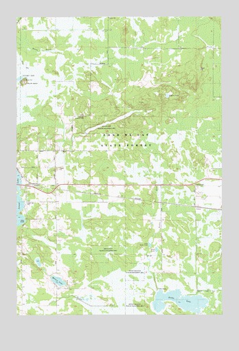
Cromwell East, MN USGS Topographic Map
Click on map above to begin viewing in our Map Viewer.

This topographic map contains these locations and features:
Feature Name Type Latitude Longitude GNIS ID View Map
Black LakeLakeN46.6523°W92.7903°640218View Map
City of CromwellCivilN46.6795°W92.8731°2393676View Map
CoronaLocaleN46.6706°W92.7661°2074116View Map
CoronaPopulated PlaceN46.6705°W92.7663°654728View Map
Corona Post Office (historical)Post OfficeN46.6706°W92.7661°2074115View Map
County Ditch Number TwoCanalN46.6352°W92.7605°641786View Map
Cromwell Lookout TowerTowerN46.7080°W92.8333°1815079View Map
Fond du Lac State ForestForestN46.6769°W92.7924°661296View Map
Island Lake CampgroundsLocaleN46.6764°W92.8708°2073842View Map
Island Lake ParkParkN46.6713°W92.8691°1815076View Map
Kettle LakeLakeN46.6310°W92.7804°646126View Map
Kettle Lake State Wildlife Management AreaParkN46.6277°W92.8016°1815074View Map
Little Kettle LakeLakeN46.6543°W92.7943°646828View Map
Mervin State Wildlife Management AreaParkN46.6505°W92.8196°1815075View Map
Merwin LakeLakeN46.6392°W92.8502°647781View Map
Rogers LakeLakeN46.7168°W92.7834°1815080View Map
Sawyer State Wildlife Management AreaParkN46.7055°W92.8141°1815077View Map
Skunk IslandIslandN46.7227°W92.8705°1815078View Map
Springer LakeLakeN46.7240°W92.8733°652488View Map
Township of EagleCivilN46.6350°W92.8732°664015View Map
Unorganized Territory of North CarltonCivilN46.6889°W92.7626°665146View Map

Note: Coordinates in the location and feature list above are referenced to NAD83 datum.


Copyright (C) 2008-2024 Ryan Niemi / Sunset Dynamics ... All Rights Reserved