TopoQuest Logo
Do you find TopoQuest useful?
Help keep TopoQuest running and adding new maps/features by donating!
Bitcoin:  19c7KJd3qBynnjoSw5npx9KScwjBe4ifkT
Litecoin:  LXs6TkuXGGXo1vDsWCkWVdjQX94eUKd6ui
Home View Maps Find Maps Find Places Resources & Links


Crooked Creek Pass, Colorado Topographic Map

USGS Map Title: Crooked Creek Pass, CO
USGS Map MRC: 39106D6
DRG (GeoTIFF) Download: o39106d6.tif


Neighboring USGS Topographic Map Quads:


  The Seven Hermits, CO  
39106E7
 

  Fulford, CO  
39106E6
 

  Grouse Mountain, CO  
39106E5
 

  Red Creek, CO  
39106D7
 

  Crooked Creek Pass, CO  
39106D6
 

  Mount Jackson, CO  
39106D5
 

  Ruedi Reservoir, CO  
39106C7
 

  Meredith, CO  
39106C6
 

  Nast, CO  
39106C5


Map MRC Location:

N40°
W107°
N40°
W106°
H8 H7 H6 H5 H4 H3 H2 H1
G8 G7 G6 G5 G4 G3 G2 G1
F8 F7 F6 F5 F4 F3 F2 F1
E8 E7 E6 E5 E4 E3 E2 E1
D8 D7 D6 D5 D4 D3 D2 D1
C8 C7 C6 C5 C4 C3 C2 C1
B8 B7 B6 B5 B4 B3 B2 B1
A8 A7 A6 A5 A4 A3 A2 A1
N39°
W107°
N39°
W106°

Crooked Creek Pass, CO USGS 1:24K Topographic Map Preview:
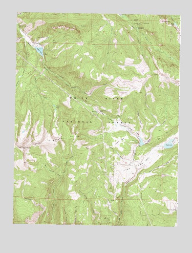
Crooked Creek Pass, CO USGS Topographic Map
Click on map above to begin viewing in our Map Viewer.

This topographic map contains these locations and features:
Feature Name Type Latitude Longitude GNIS ID View Map
Adam CampgroundLocaleN39.4708°W106.7295°179443View Map
Adam Mountain SpringSpringN39.4913°W106.7485°179439View Map
Alicia Lake DamDamN39.3867°W106.6373°201096View Map
Alicia Lake ReservoirReservoirN39.3867°W106.6373°201097View Map
Antone TrailTrailN39.4980°W106.7475°202659View Map
Antones Cabin CreekStreamN39.4828°W106.7425°179438View Map
Billings SpringSpringN39.4415°W106.6869°179456View Map
Borah GulchValleyN39.4851°W106.7451°179417View Map
Burnt MountainSummitN39.3847°W106.6281°179468View Map
Caliente SpringSpringN39.4963°W106.6606°179448View Map
Corral GulchValleyN39.4121°W106.6594°179464View Map
Craig PeakSummitN39.4958°W106.6378°179450View Map
Crooked CreekStreamN39.4275°W106.6553°179459View Map
Crooked Creek DamDamN39.4233°W106.6556°199404View Map
Crooked Creek ParkFlatN39.4311°W106.6623°179460View Map
Crooked Creek PassGapN39.4414°W106.6853°179455View Map
Crooked Creek ReservoirReservoirN39.4245°W106.6536°179462View Map
East Jakeman CreekStreamN39.3997°W106.7161°179479View Map
Fulford Cave CampgroundLocaleN39.4917°W106.6589°179445View Map
Fulford Cave SpringSpringN39.4942°W106.6554°179447View Map
Fulford MineMineN39.4944°W106.6520°1684204View Map
Ironedge TrailTrailN39.4817°W106.6556°179451View Map
Kuntz CreekStreamN39.3792°W106.6806°179472View Map
Lake Charles TrailTrailN39.4619°W106.6350°202660View Map
Leeman GulchValleyN39.4667°W106.7264°179452View Map
Leeman LakesLakeN39.4358°W106.7195°179453View Map
Lime ParkFlatN39.4097°W106.6550°179465View Map
Little Lime CreekStreamN39.4075°W106.6553°179463View Map
Middle CreekStreamN39.4269°W106.6548°179461View Map
Mount EveSummitN39.4925°W106.7014°179444View Map
Mount ThomasSummitN39.4200°W106.7436°179458View Map
Nolan LakeLakeN39.4945°W106.6291°179449View Map
O-Z DamDamN39.4800°W106.7356°199392View Map
Slim Jim GulchValleyN39.4065°W106.6555°179467View Map
Sneve GulchValleyN39.4812°W106.7348°179442View Map
Soap SpringSpringN39.4850°W106.7338°179440View Map
Spine CreekStreamN39.4514°W106.6934°179454View Map
Sylvan LakeLakeN39.4773°W106.7318°179441View Map
West Jakeman CreekStreamN39.3997°W106.7161°179478View Map
Woods LakeLakeN39.4234°W106.6326°179466View Map

Note: Coordinates in the location and feature list above are referenced to NAD83 datum.


Copyright (C) 2008-2025 Ryan Niemi / Sunset Dynamics ... All Rights Reserved