TopoQuest Logo
Do you find TopoQuest useful?
Help keep TopoQuest running and adding new maps/features by donating!
Bitcoin:  19c7KJd3qBynnjoSw5npx9KScwjBe4ifkT
Litecoin:  LXs6TkuXGGXo1vDsWCkWVdjQX94eUKd6ui
Home View Maps Find Maps Find Places Resources & Links


Cross Cut, Texas Topographic Map

USGS Map Title: Cross Cut, TX
USGS Map MRC: 32099A2
DRG (GeoTIFF) Download: o32099a2.tif


Neighboring USGS Topographic Map Quads:


  Rowden, TX  
32099B3
 

  Cross Plains North, TX  
32099B2
 

  Sabanno, TX  
32099B1
 

  Webbville, TX  
32099A3
 

  Cross Cut, TX  
32099A2
 

  Pioneer, TX  
32099A1
 

  Coleman NE, TX  
31099H3
 

  Burkett, TX  
31099H2
 

  Byrds, TX  
31099H1


Map MRC Location:

N33°
W100°
N33°
W99°
H8 H7 H6 H5 H4 H3 H2 H1
G8 G7 G6 G5 G4 G3 G2 G1
F8 F7 F6 F5 F4 F3 F2 F1
E8 E7 E6 E5 E4 E3 E2 E1
D8 D7 D6 D5 D4 D3 D2 D1
C8 C7 C6 C5 C4 C3 C2 C1
B8 B7 B6 B5 B4 B3 B2 B1
A8 A7 A6 A5 A4 A3 A2 A1
N32°
W100°
N32°
W99°

Cross Cut, TX USGS 1:24K Topographic Map Preview:
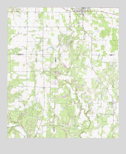
Cross Cut, TX USGS Topographic Map
Click on map above to begin viewing in our Map Viewer.

This topographic map contains these locations and features:
Feature Name Type Latitude Longitude GNIS ID View Map
Burkett LakeReservoirN32.0073°W99.2312°1858670View Map
Burkett Oil FieldOilfieldN32.0301°W99.2281°1331680View Map
Callahan County Deputy Constable's OfficeBuildingN32.1219°W99.1658°2750715View Map
Callahan County Deputy Sheriff's OfficeBuildingN32.1219°W99.1658°2750387View Map
Cross CutPopulated PlaceN32.0338°W99.1326°1333713View Map
Cross Cut CemeteryCemeteryN32.0229°W99.1317°1333714View Map
Cross Plains City HallBuildingN32.1241°W99.1651°2753654View Map
Cross Plains Oil FieldOilfieldN32.1015°W99.2015°1333720View Map
Cross Plains Police DepartmentBuildingN32.1241°W99.1650°2750498View Map
Cross Plains Volunteer Fire DepartmentBuildingN32.1239°W99.1685°2551312View Map
Dinner BranchStreamN32.0657°W99.1812°1334371View Map
Dooley CreekStreamN32.0601°W99.1903°1334494View Map
Dressy CemeteryCemeteryN32.1062°W99.2315°1334612View Map
Little Pecan BayouStreamN32.0135°W99.2367°1340151View Map
McDonough LakeReservoirN32.1165°W99.1681°1860010View Map
McDonough Lake DamDamN32.1168°W99.1687°1860009View Map
Robert E Howard HouseBuildingN32.1215°W99.1720°2031681View Map
Soil Conservation Service Site 10 DamDamN32.0685°W99.1837°1859653View Map
Soil Conservation Service Site 10 ReservoirReservoirN32.0696°W99.1856°1859654View Map
Soil Conservation Service Site 11a DamDamN32.0401°W99.1870°1859649View Map
Soil Conservation Service Site 11a ReservoirReservoirN32.0399°W99.1860°1859650View Map
Soil Conservation Service Site 12 DamDamN32.0618°W99.1920°1859647View Map
Soil Conservation Service Site 12 ReservoirReservoirN32.0627°W99.1941°1859648View Map
Soil Conservation Service Site 22 DamDamN32.1235°W99.2437°1860007View Map
Soil Conservation Service Site 22 ReservoirReservoirN32.1234°W99.2446°1860008View Map
Soil Conservation Service Site 26 DamDamN32.0518°W99.1337°1859651View Map
Soil Conservation Service Site 26 ReservoirReservoirN32.0533°W99.1328°1859652View Map
Texas Department of Public Safety Highway Patrol OfficeBuildingN32.1219°W99.1658°2750716View Map

Note: Coordinates in the location and feature list above are referenced to NAD83 datum.


Copyright (C) 2008-2025 Ryan Niemi / Sunset Dynamics ... All Rights Reserved