TopoQuest Logo
Do you find TopoQuest useful?
Help keep TopoQuest running and adding new maps/features by donating!
Bitcoin:  19c7KJd3qBynnjoSw5npx9KScwjBe4ifkT
Litecoin:  LXs6TkuXGGXo1vDsWCkWVdjQX94eUKd6ui
Home View Maps Find Maps Find Places Resources & Links


Culver, Kansas Topographic Map

USGS Map Title: Culver, KS
USGS Map MRC: 38097H7
DRG (GeoTIFF) Download: o38097h7.tif


Neighboring USGS Topographic Map Quads:


  Tescott, KS  
39097A8
 

  Tescott SE, KS  
39097A7
 

  Minneapolis South, KS  
39097A6
 

  Juniata, KS  
38097H8
 

  Culver, KS  
38097H7
 

  Trenton, KS  
38097H6
 

  Brookville SW, KS  
38097G8
 

  Brookville, KS  
38097G7
 

  Salina SW, KS  
38097G6


Map MRC Location:

N39°
W98°
N39°
W97°
H8 H7 H6 H5 H4 H3 H2 H1
G8 G7 G6 G5 G4 G3 G2 G1
F8 F7 F6 F5 F4 F3 F2 F1
E8 E7 E6 E5 E4 E3 E2 E1
D8 D7 D6 D5 D4 D3 D2 D1
C8 C7 C6 C5 C4 C3 C2 C1
B8 B7 B6 B5 B4 B3 B2 B1
A8 A7 A6 A5 A4 A3 A2 A1
N38°
W98°
N38°
W97°

Culver, KS USGS 1:24K Topographic Map Preview:
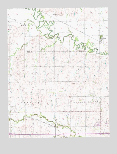
Culver, KS USGS Topographic Map
Click on map above to begin viewing in our Map Viewer.

This topographic map contains these locations and features:
Feature Name Type Latitude Longitude GNIS ID View Map
City of CulverCivilN38.9686°W97.7591°2393693View Map
CulverPopulated PlaceN38.9708°W97.7589°476627View Map
Culver Rural Fire District 5BuildingN38.9725°W97.7610°2111246View Map
Eff CreekStreamN38.8756°W97.7934°476623View Map
Franklin CemeteryCemeteryN38.9837°W97.8739°476629View Map
Saline County Fire District 3 - Glendale StationBuildingN38.8977°W97.8740°2111836View Map
Saline County Fire District 3 - Hedville StationBuildingN38.8911°W97.7619°2111837View Map
Shaw CreekStreamN38.9575°W97.7720°476624View Map
Sundowner West Meadows Mobile Home ParkPopulated PlaceN38.8896°W97.7627°2694165View Map
Sundowner West Recreational Vehicle ParkLocaleN38.8879°W97.7624°2694459View Map
Table Rock CreekStreamN38.9736°W97.8295°476625View Map
Team Marketing Alliance Grain Elevator Number 42LocaleN38.9669°W97.7602°2695247View Map
Township of GlendaleCivilN38.9146°W97.8730°476622View Map
Township of Pleasant ValleyCivilN38.9145°W97.7615°476630View Map
Tripp SchoolSchoolN38.9939°W97.8173°476628View Map

Note: Coordinates in the location and feature list above are referenced to NAD83 datum.


Copyright (C) 2008-2025 Ryan Niemi / Sunset Dynamics ... All Rights Reserved