TopoQuest Logo
Do you find TopoQuest useful?
Help keep TopoQuest running and adding new maps/features by donating!
Bitcoin:  19c7KJd3qBynnjoSw5npx9KScwjBe4ifkT
Litecoin:  LXs6TkuXGGXo1vDsWCkWVdjQX94eUKd6ui
Home View Maps Find Maps Find Places Resources & Links


Cumberland, Washington Topographic Map

USGS Map Title: Cumberland, WA
USGS Map MRC: 47121C8
DRG (GeoTIFF) Download: o47121c8.tif


Neighboring USGS Topographic Map Quads:


  Maple Valley, WA  
47122D1
 

  Hobart, WA  
47121D8
 

  North Bend, WA  
47121D7
 

  Black Diamond, WA  
47122C1
 

  Cumberland, WA  
47121C8
 

  Eagle Gorge, WA  
47121C7
 

  Buckley, WA  
47122B1
 

  Enumclaw, WA  
47121B8
 

  Cyclone Creek, WA  
47121B7


Map MRC Location:

N48°
W122°
N48°
W121°
H8 H7 H6 H5 H4 H3 H2 H1
G8 G7 G6 G5 G4 G3 G2 G1
F8 F7 F6 F5 F4 F3 F2 F1
E8 E7 E6 E5 E4 E3 E2 E1
D8 D7 D6 D5 D4 D3 D2 D1
C8 C7 C6 C5 C4 C3 C2 C1
B8 B7 B6 B5 B4 B3 B2 B1
A8 A7 A6 A5 A4 A3 A2 A1
N47°
W122°
N47°
W121°

Cumberland, WA USGS 1:24K Topographic Map Preview:
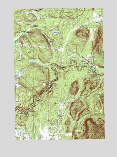
Cumberland, WA USGS Topographic Map
Click on map above to begin viewing in our Map Viewer.

This topographic map contains these locations and features:
Feature Name Type Latitude Longitude GNIS ID View Map
A Country Garden Montessori SchoolSchoolN47.2536°W121.9892°2605924View Map
Bass LakeLakeN47.2549°W121.9956°1516181View Map
BaynePopulated PlaceN47.2951°W121.9096°1516203View Map
Bayne JunctionPopulated PlaceN47.3009°W121.9087°1516204View Map
Coal CreekStreamN47.2682°W121.9562°1517895View Map
CumberlandPopulated PlaceN47.2829°W121.9271°1518407View Map
Deep CreekStreamN47.2748°W121.9384°1518584View Map
Deep LakeLakeN47.2736°W121.9399°1518598View Map
DurhamPopulated PlaceN47.3382°W121.8909°1519018View Map
Enumclaw MountainSummitN47.2518°W121.8979°1519367View Map
Fish LakeLakeN47.2707°W121.9561°1519589View Map
FranklinPopulated PlaceN47.3009°W121.9529°1530308View Map
Franklin CreekStreamN47.3045°W121.9507°1530309View Map
GeorgetownPopulated PlaceN47.3576°W121.9737°1519926View Map
Ginder LakeLakeN47.3268°W121.9940°1519967View Map
Green River GorgeStreamN47.2879°W121.9671°1520327View Map
Green River Gorge BridgeBridgeN47.3017°W121.9502°2605459View Map
Green River Gorge Conservation AreaParkN47.2929°W121.9654°1530436View Map
Green River Gorge Recreation AreaLocaleN47.3037°W121.9490°1534127View Map
Green River Gorge State ParkParkN47.2898°W121.9679°1529792View Map
Green River Rearing PondReservoirN47.3232°W121.9046°1532753View Map
Green River Rearing Pond DamDamN47.3232°W121.9046°1532752View Map
Green River Rearing PondsReservoirN47.3234°W121.9034°1533380View Map
Hyde LakeLakeN47.2849°W121.9384°1521111View Map
KanaskatPopulated PlaceN47.3204°W121.8937°1521559View Map
Kanaskat JunctionPopulated PlaceN47.3320°W121.8918°1521560View Map
Kanaskat-Palmer Recreation AreaParkN47.3170°W121.8921°1533381View Map
Kanaskat-Palmer State ParkParkN47.3176°W121.9026°1529816View Map
KangleyPopulated PlaceN47.3618°W121.8801°1521565View Map
King County Fire Protection District 28 Enumclaw Fire Department Station 2BuildingN47.2825°W121.9283°2619591View Map
King County Fire Protection District 43 Maple Valley Fire and Life Safety Station 82BuildingN47.3575°W121.9752°2619571View Map
King County Fire Protection District 47 Station 88BuildingN47.3621°W121.8789°2619564View Map
King County Fire Protection District 47 Station 89BuildingN47.3213°W121.8965°2619565View Map
Lake Number TwelveLakeN47.3253°W121.9759°1521856View Map
LandsburgPopulated PlaceN47.3748°W121.9718°1521884View Map
Little Retreat LakeLakeN47.3481°W121.9498°1530516View Map
Misty Mountain Mobile Home ParkPopulated PlaceN47.2522°W121.9881°2607189View Map
Mud LakeLakeN47.3204°W121.9878°1523473View Map
Muskrat LakeLakeN47.2651°W121.9437°1523531View Map
NacoPopulated PlaceN47.2770°W121.9298°1523555View Map
Nolte State ParkParkN47.2695°W121.9393°1530056View Map
PalmerPopulated PlaceN47.3143°W121.8923°1524150View Map
Palmer JunctionPopulated PlaceN47.3120°W121.8901°1524154View Map
Pautzky Salmon PondsReservoirN47.2790°W121.9751°1533382View Map
RavensdalePopulated PlaceN47.3523°W121.9837°1524908View Map
Ravensdale CemeteryCemeteryN47.3573°W121.9862°1533379View Map
Ravensdale Census Designated PlaceCensusN47.3564°W121.9692°2409146View Map
Ravensdale LakeLakeN47.3508°W121.9925°1524909View Map
Ravensdale PitReservoirN47.3481°W121.9951°1532374View Map
Ravensdale Pit DamDamN47.3482°W121.9946°1532373View Map
Ravensdale Post OfficePost OfficeN47.3576°W121.9787°1533378View Map
Raver SubstationBuildingN47.3365°W121.9334°1533377View Map
Retreat LakeLakeN47.3521°W121.9418°1525011View Map
Sugarloaf MountainSummitN47.3512°W121.9034°1526669View Map
Walker LakeLakeN47.2642°W121.9085°1527766View Map

Note: Coordinates in the location and feature list above are referenced to NAD83 datum.


Copyright (C) 2008-2025 Ryan Niemi / Sunset Dynamics ... All Rights Reserved