TopoQuest Logo
Do you find TopoQuest useful?
Help keep TopoQuest running and adding new maps/features by donating!
Bitcoin:  19c7KJd3qBynnjoSw5npx9KScwjBe4ifkT
Litecoin:  LXs6TkuXGGXo1vDsWCkWVdjQX94eUKd6ui
Home View Maps Find Maps Find Places Resources & Links


Cumberland Island North, Georgia Topographic Map

USGS Map Title: Cumberland Island North, GA
USGS Map MRC: 30081H4
DRG (GeoTIFF) Download: o30081h4.tif


Neighboring USGS Topographic Map Quads:


  Dover Bluff, GA  
31081A5
 

  Jekyll Island, GA  
31081A4


  Kingsland NE, GA  
30081H5
 

  Cumberland Island North, GA  
30081H4


  Harrietts Bluff, GA  
30081G5
 

  Cumberland Island South, GA  
30081G4


Map MRC Location:

N31°
W82°
N31°
W81°
H8 H7 H6 H5 H4 H3 H2 H1
G8 G7 G6 G5 G4 G3 G2 G1
F8 F7 F6 F5 F4 F3 F2 F1
E8 E7 E6 E5 E4 E3 E2 E1
D8 D7 D6 D5 D4 D3 D2 D1
C8 C7 C6 C5 C4 C3 C2 C1
B8 B7 B6 B5 B4 B3 B2 B1
A8 A7 A6 A5 A4 A3 A2 A1
N30°
W82°
N30°
W81°

Cumberland Island North, GA USGS 1:24K Topographic Map Preview:
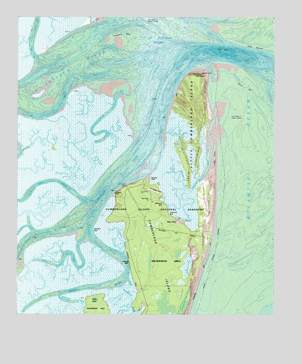
Cumberland Island North, GA USGS Topographic Map
Click on map above to begin viewing in our Map Viewer.

This topographic map contains these locations and features:
Feature Name Type Latitude Longitude GNIS ID View Map
Abraham PointCapeN30.9108°W81.4618°310374View Map
Brickhill BluffCliffN30.8975°W81.4448°311777View Map
Brickhill RiverChannelN30.8819°W81.4879°311778View Map
Brockington CreekStreamN30.9269°W81.4173°1671309View Map
Brockington CreekStreamN30.9319°W81.4120°311820View Map
Burbank PointCapeN30.9325°W81.4354°1796312View Map
Christmas CreekStreamN30.9341°W81.4090°312663View Map
Cumberland CemeteryCemeteryN30.9266°W81.4404°1796313View Map
Cumberland WharfLocaleN30.9291°W81.4468°1796308View Map
Dover CreekStreamN30.9822°W81.4901°313601View Map
East RidgeRidgeN30.9413°W81.4129°1796309View Map
First African Baptist ChurchChurchN30.9236°W81.4354°1796323View Map
First African ChurchChurchN30.9236°W81.4343°1796311View Map
Halfmoon BluffCliffN30.9236°W81.4304°315023View Map
Hawkins CreekChannelN30.9063°W81.4495°315244View Map
High BluffCliffN30.9300°W81.4448°1671359View Map
High PointPopulated PlaceN30.9152°W81.4223°331972View Map
High Point-Halfmoon Bluff Historic DistrictParkN30.9186°W81.4276°1671360View Map
Horseshoe ShoalsBarN30.9897°W81.4495°315726View Map
Little Cumberland IslandIslandN30.9511°W81.4134°317049View Map
Little Cumberland Island LighthouseLocaleN30.9761°W81.4134°317050View Map
Long PointCapeN30.9405°W81.4037°317376View Map
Malkintooh CreekChannelN30.8830°W81.4454°317640View Map
Mud CreekChannelN30.8975°W81.4779°319099View Map
Mumford CreekChannelN30.8808°W81.4704°319147View Map
North BreakersAreaN30.9880°W81.3845°1796315View Map
Pelican SpitBarN30.9750°W81.3915°320351View Map
Red Bridge (historical)BridgeN30.8791°W81.4368°1796324View Map
Saint Andrew SoundBayN30.9883°W81.4284°342354View Map
Sanctuary RidgeRidgeN30.9391°W81.4170°1796310View Map
Satilla RiverStreamN30.9836°W81.4582°356520View Map
Shell CreekChannelN30.9505°W81.4223°322826View Map
Shellbine CreekStreamN30.9102°W81.4918°322829View Map
Stockwell BluffCliffN30.9172°W81.4259°323638View Map
Table PointCapeN30.8836°W81.4576°323879View Map
Terrapin PointCapeN30.9261°W81.4515°324008View Map
The HoleChannelN30.9855°W81.3990°1796314View Map
The HoleBayN30.9858°W81.4004°1796328View Map
Whitney LakeLakeN30.8987°W81.4152°325237View Map

Note: Coordinates in the location and feature list above are referenced to NAD83 datum.


Copyright (C) 2008-2025 Ryan Niemi / Sunset Dynamics ... All Rights Reserved