TopoQuest Logo
Do you find TopoQuest useful?
Help keep TopoQuest running and adding new maps/features by donating!
Bitcoin:  19c7KJd3qBynnjoSw5npx9KScwjBe4ifkT
Litecoin:  LXs6TkuXGGXo1vDsWCkWVdjQX94eUKd6ui
Home View Maps Find Maps Find Places Resources & Links


Curlew, Washington Topographic Map

USGS Map Title: Curlew, WA
USGS Map MRC: 48118H5
DRG (GeoTIFF) Download: o48118h5.tif


Neighboring USGS Topographic Map Quads:


  Vulcan Mountain, WA  
48118H6
 

  Curlew, WA  
48118H5
 

  Boundary Mountain, WA  
48118H4
 

  Karamin, WA  
48118G6
 

  Malo, WA  
48118G5
 

  Mount Leona, WA  
48118G4


Map MRC Location:

N49°
W119°
N49°
W118°
H8 H7 H6 H5 H4 H3 H2 H1
G8 G7 G6 G5 G4 G3 G2 G1
F8 F7 F6 F5 F4 F3 F2 F1
E8 E7 E6 E5 E4 E3 E2 E1
D8 D7 D6 D5 D4 D3 D2 D1
C8 C7 C6 C5 C4 C3 C2 C1
B8 B7 B6 B5 B4 B3 B2 B1
A8 A7 A6 A5 A4 A3 A2 A1
N48°
W119°
N48°
W118°

Curlew, WA USGS 1:24K Topographic Map Preview:
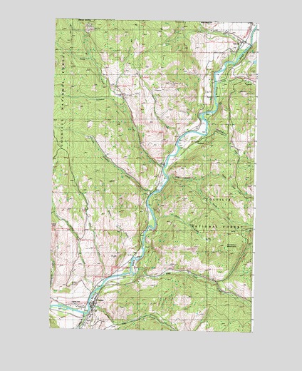
Curlew, WA USGS Topographic Map
Click on map above to begin viewing in our Map Viewer.

This topographic map contains these locations and features:
Feature Name Type Latitude Longitude GNIS ID View Map
Alkali CreekStreamN48.8938°W118.5917°1515810View Map
Ansorge Hotel MuseumBuildingN48.8838°W118.5999°2610442View Map
CurlewPopulated PlaceN48.8854°W118.5995°1518417View Map
Curlew Administration SiteLocaleN48.8796°W118.6006°1531603View Map
Curlew Airport (historical)AirportN48.8888°W118.6067°1533728View Map
Curlew BridgeBridgeN48.8855°W118.6014°2607982View Map
Curlew Census Designated PlaceCensusN48.8777°W118.6045°2586732View Map
Curlew CreekStreamN48.8807°W118.6036°1518418View Map
Curlew DivisionCivilN48.8913°W118.6111°1939489View Map
Curlew Post OfficePost OfficeN48.8851°W118.6000°2606938View Map
DanvillePopulated PlaceN48.9924°W118.5081°1518480View Map
Danville Census Designated PlaceCensusN48.9936°W118.5069°2631349View Map
Danville Post OfficePost OfficeN48.9926°W118.5084°2606941View Map
Day CreekStreamN48.9371°W118.5536°1518516View Map
Drummer MountainSummitN48.9091°W118.5225°1518929View Map
Ferry / Okanogan County Fire District 14 DanvilleBuildingN48.9927°W118.5085°2619679View Map
Ferry / Okanogan Fire District 14BuildingN48.8849°W118.5999°2643916View Map
Ferry / Okanogan Fire District 14 CurlewBuildingN48.8852°W118.6090°2643917View Map
Goosmus CreekStreamN48.9399°W118.5564°1520157View Map
HurlburtLocaleN48.9521°W118.5331°1528499View Map
July CreekStreamN48.9891°W118.5072°1521496View Map
Kettle River BridgeBridgeN48.8814°W118.6040°2607983View Map
LaFleur CreekStreamN48.8907°W118.5967°1521801View Map
Little Goosmus CreekStreamN48.9299°W118.5645°1522224View Map
Lone Ranch CreekStreamN48.9749°W118.5253°1522374View Map
Long Alec CreekStreamN48.8827°W118.5997°1522384View Map
North Ferry County AmbulanceBuildingN48.8852°W118.6088°2643722View Map
North Fork Day CreekStreamN48.9357°W118.5356°1523768View Map
North Fork Goosmus CreekStreamN48.9621°W118.5789°1523784View Map
Rincom CreekStreamN48.9138°W118.5675°1525059View Map
Shasket CreekStreamN48.9530°W118.5467°1525619View Map
Skiffington CreekStreamN48.9571°W118.5309°1525863View Map
South Fork Day CreekStreamN48.9357°W118.5353°1526187View Map
West Deer CreekStreamN48.8974°W118.5731°1527925View Map
White CreekStreamN48.9202°W118.5614°1528055View Map

Note: Coordinates in the location and feature list above are referenced to NAD83 datum.


Copyright (C) 2008-2025 Ryan Niemi / Sunset Dynamics ... All Rights Reserved