TopoQuest Logo
Do you find TopoQuest useful?
Help keep TopoQuest running and adding new maps/features by donating!
Bitcoin:  19c7KJd3qBynnjoSw5npx9KScwjBe4ifkT
Litecoin:  LXs6TkuXGGXo1vDsWCkWVdjQX94eUKd6ui
Home View Maps Find Maps Find Places Resources & Links


Custer, Kentucky Topographic Map

USGS Map Title: Custer, KY
USGS Map MRC: 37086F3
DRG (GeoTIFF) Download: o37086f3.tif


Neighboring USGS Topographic Map Quads:


  Hardinsburg, KY  
37086G4
 

  Garfield, KY  
37086G3
 

  Big Spring, KY  
37086G2
 

  Kingswood, KY  
37086F4
 

  Custer, KY  
37086F3
 

  Constantine, KY  
37086F2
 

  McDaniels, KY  
37086E4
 

  Madrid, KY  
37086E3
 

  Big Clifty, KY  
37086E2


Map MRC Location:

N38°
W87°
N38°
W86°
H8 H7 H6 H5 H4 H3 H2 H1
G8 G7 G6 G5 G4 G3 G2 G1
F8 F7 F6 F5 F4 F3 F2 F1
E8 E7 E6 E5 E4 E3 E2 E1
D8 D7 D6 D5 D4 D3 D2 D1
C8 C7 C6 C5 C4 C3 C2 C1
B8 B7 B6 B5 B4 B3 B2 B1
A8 A7 A6 A5 A4 A3 A2 A1
N37°
W87°
N37°
W86°

Custer, KY USGS 1:24K Topographic Map Preview:
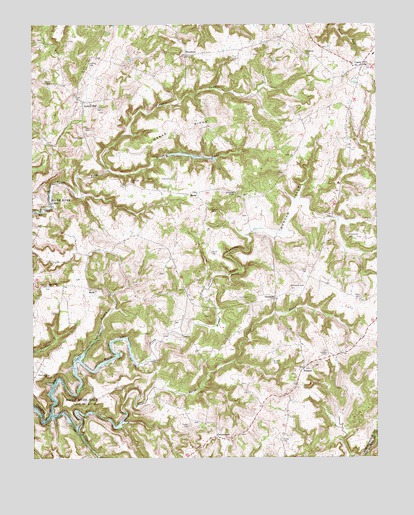
Custer, KY USGS Topographic Map
Click on map above to begin viewing in our Map Viewer.

This topographic map contains these locations and features:
Feature Name Type Latitude Longitude GNIS ID View Map
Alexander CemeteryCemeteryN37.7051°W86.3397°485823View Map
Alexander ChapelChurchN37.7017°W86.3016°485826View Map
Ben Clark BranchStreamN37.6378°W86.3683°486839View Map
BurasPopulated PlaceN37.7017°W86.3161°507619View Map
Butler CemeteryCemeteryN37.6964°W86.3105°488508View Map
Carman CemeteryCemeteryN37.7326°W86.3686°488939View Map
CenterviewPopulated PlaceN37.6309°W86.3086°507679View Map
Clear ProngStreamN37.6334°W86.3586°489641View Map
Comer CemeteryCemeteryN37.6306°W86.2850°489907View Map
Cook CemeteryCemeteryN37.6789°W86.2752°490003View Map
CusterPopulated PlaceN37.7384°W86.2547°490511View Map
Davis CemeteryCemeteryN37.7176°W86.3561°490652View Map
Drane CemeteryCemeteryN37.6845°W86.3105°491101View Map
Duncan ValleyValleyN37.6895°W86.2858°491308View Map
Elliot CemeteryCemeteryN37.6714°W86.2966°491703View Map
Fair View ChurchChurchN37.6750°W86.3694°491871View Map
FairfieldPopulated PlaceN37.6714°W86.2872°507969View Map
Fiddlers CreekStreamN37.7081°W86.3466°492057View Map
Goodhope CemeteryCemeteryN37.7426°W86.2764°492970View Map
Horsley CemeteryCemeteryN37.7389°W86.3541°494616View Map
HudsonPopulated PlaceN37.6512°W86.2766°508289View Map
Ivory HollowValleyN37.6681°W86.3081°495062View Map
Locust HillPopulated PlaceN37.7278°W86.3566°508488View Map
Marks RidgeRidgeN37.7203°W86.3216°497551View Map
McCamish CemeteryCemeteryN37.6892°W86.2605°497770View Map
McDaniels-Hudson DivisionCivilN37.6821°W86.3170°1936887View Map
MookPopulated PlaceN37.6734°W86.3522°508632View Map
Muddy ProngStreamN37.6531°W86.3575°499048View Map
New Salem ChurchChurchN37.6489°W86.3694°499393View Map
Nichols CemeteryCemeteryN37.6528°W86.2880°499465View Map
Pile CemeteryCemeteryN37.7056°W86.3247°500623View Map
Sharp CemeteryCemeteryN37.6714°W86.2558°503260View Map
Tucker CemeteryCemeteryN37.6345°W86.3186°505536View Map
Turpin CemeteryCemeteryN37.7201°W86.3561°505681View Map
Whitworth CemeteryCemeteryN37.6745°W86.2819°506703View Map
WoodrowPopulated PlaceN37.7414°W86.3197°509402View Map

Note: Coordinates in the location and feature list above are referenced to NAD83 datum.


Copyright (C) 2008-2025 Ryan Niemi / Sunset Dynamics ... All Rights Reserved