TopoQuest Logo
Do you find TopoQuest useful?
Help keep TopoQuest running and adding new maps/features by donating!
Bitcoin:  19c7KJd3qBynnjoSw5npx9KScwjBe4ifkT
Litecoin:  LXs6TkuXGGXo1vDsWCkWVdjQX94eUKd6ui
Home View Maps Find Maps Find Places Resources & Links


Dalhart West, Texas Topographic Map

USGS Map Title: Dalhart West, TX
USGS Map MRC: 36102A5
DRG (GeoTIFF) Download: o36102a5.tif


Neighboring USGS Topographic Map Quads:


  Bolin, TX  
36102B6
 

  Bolin NE, TX  
36102B5
 

  Chamberlin, TX  
36102B4
 

  Canyon School, TX  
36102A6
 

  Dalhart West, TX  
36102A5
 

  Dalhart East, TX  
36102A4
 

  King, TX  
35102H6
 

  Pardue Camp, TX  
35102H5
 

  Hartley, TX  
35102H4


Map MRC Location:

N37°
W103°
N37°
W102°
H8 H7 H6 H5 H4 H3 H2 H1
G8 G7 G6 G5 G4 G3 G2 G1
F8 F7 F6 F5 F4 F3 F2 F1
E8 E7 E6 E5 E4 E3 E2 E1
D8 D7 D6 D5 D4 D3 D2 D1
C8 C7 C6 C5 C4 C3 C2 C1
B8 B7 B6 B5 B4 B3 B2 B1
A8 A7 A6 A5 A4 A3 A2 A1
N36°
W103°
N36°
W102°

Dalhart West, TX USGS 1:24K Topographic Map Preview:
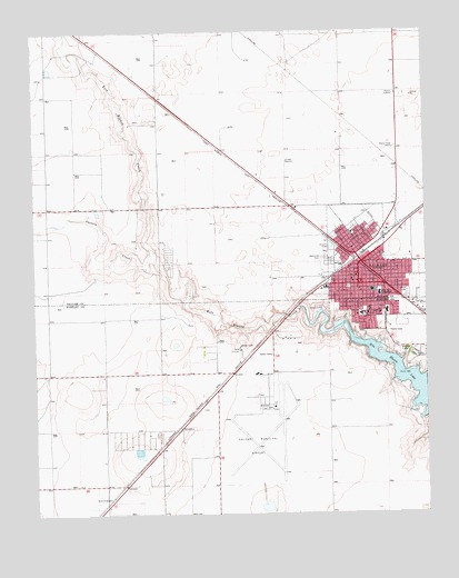
Dalhart West, TX USGS Topographic Map
Click on map above to begin viewing in our Map Viewer.

This topographic map contains these locations and features:
Feature Name Type Latitude Longitude GNIS ID View Map
Allyn Finch Intermediate SchoolSchoolN36.0569°W102.5147°1351038View Map
Antioch Baptist ChurchChurchN36.0670°W102.5146°2017475View Map
Calvary Assembly of God ChurchChurchN36.0684°W102.5235°2017474View Map
Carrizo CreekStreamN36.0681°W102.5860°1353867View Map
Central United Methodist ChurchChurchN36.0611°W102.5244°2017478View Map
City of DalhartCivilN36.0580°W102.5123°2410286View Map
Coon Memorial HospitalHospitalN36.0514°W102.5214°1354934View Map
Coon Memorial Hospital and HomeHospitalN36.0525°W102.5221°2015774View Map
DalhartPopulated PlaceN36.0595°W102.5132°1355552View Map
Dalhart Army Air Field (historical)MilitaryN36.0217°W102.5542°2091951View Map
Dalhart City HallBuildingN36.0644°W102.5241°2753658View Map
Dalhart Elementary SchoolSchoolN36.0524°W102.5131°2004584View Map
Dalhart Emergency Medical ServicesBuildingN36.0516°W102.5216°2551952View Map
Dalhart Emergency Medical ServicesBuildingN36.0645°W102.5241°2655893View Map
Dalhart Intermediate SchoolSchoolN36.0581°W102.5178°2004583View Map
Dalhart Junior High SchoolSchoolN36.0498°W102.5047°2004586View Map
Dalhart Municipal AirportAirportN36.0279°W102.5491°1386476View Map
Dalhart Police DepartmentBuildingN36.0638°W102.5247°2750500View Map
Dalhart Post OfficePost OfficeN36.0598°W102.5310°2731436View Map
Dalhart Volunteer Fire DepartmentBuildingN36.0645°W102.5235°2551961View Map
Dallam - Hartley County JailBuildingN36.0616°W102.5217°2738803View Map
Dallam County Sheriff's OfficeBuildingN36.0612°W102.5216°2750545View Map
First Presbyterian ChurchChurchN36.0484°W102.5180°2020115View Map
Hartley County Sheriff's OfficeBuildingN36.0526°W102.5154°2750350View Map
KXIT-AM (Dalhart)TowerN36.0959°W102.5110°1387827View Map
KXIT-FM (Dalhart)TowerN36.0959°W102.5110°1387932View Map
Lake Rita Blanca State Park TrailTrailN36.0414°W102.5077°2033492View Map
Lakeview United Methodist ChurchChurchN36.0511°W102.5155°2020114View Map
Lincoln Street Baptist ChurchChurchN36.0703°W102.5219°2017476View Map
New Light Baptist ChurchChurchN36.0650°W102.5157°2017477View Map
Rita Blanca LakeReservoirN36.0350°W102.5071°1366506View Map
Rita Blanca State ParkParkN36.0339°W102.5130°2029498View Map
Saint Anthonys Catholic ChurchChurchN36.0525°W102.5194°2020113View Map
Seventh Day Adventist ChurchChurchN36.0573°W102.5244°2017417View Map
Texas Department of Criminal Justice Dalhart UnitBuildingN36.0231°W102.5596°2738605View Map
XIT Secondary SchoolSchoolN36.0566°W102.5154°2004588View Map

Note: Coordinates in the location and feature list above are referenced to NAD83 datum.


Copyright (C) 2008-2025 Ryan Niemi / Sunset Dynamics ... All Rights Reserved