TopoQuest Logo
Do you find TopoQuest useful?
Help keep TopoQuest running and adding new maps/features by donating!
Bitcoin:  19c7KJd3qBynnjoSw5npx9KScwjBe4ifkT
Litecoin:  LXs6TkuXGGXo1vDsWCkWVdjQX94eUKd6ui
Home View Maps Find Maps Find Places Resources & Links


Dayton, Texas Topographic Map

USGS Map Title: Dayton, TX
USGS Map MRC: 30094A8
DRG (GeoTIFF) Download: o30094a8.tif


Neighboring USGS Topographic Map Quads:


  Plum Grove, TX  
30095B1
 

  Simmons Bottom, TX  
30094B8
 

  Capers Ridge, TX  
30094B7
 

  Huffman, TX  
30095A1
 

  Dayton, TX  
30094A8
 

  Liberty, TX  
30094A7
 

  Crosby, TX  
29095H1
 

  Sheeks, TX  
29094H8
 

  Moss Bluff, TX  
29094H7


Map MRC Location:

N31°
W95°
N31°
W94°
H8 H7 H6 H5 H4 H3 H2 H1
G8 G7 G6 G5 G4 G3 G2 G1
F8 F7 F6 F5 F4 F3 F2 F1
E8 E7 E6 E5 E4 E3 E2 E1
D8 D7 D6 D5 D4 D3 D2 D1
C8 C7 C6 C5 C4 C3 C2 C1
B8 B7 B6 B5 B4 B3 B2 B1
A8 A7 A6 A5 A4 A3 A2 A1
N30°
W95°
N30°
W94°

Dayton, TX USGS 1:24K Topographic Map Preview:
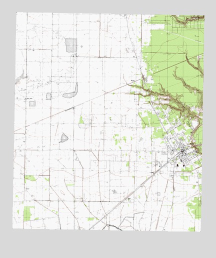
Dayton, TX USGS Topographic Map
Click on map above to begin viewing in our Map Viewer.

This topographic map contains these locations and features:
Feature Name Type Latitude Longitude GNIS ID View Map
Austin Elementary SchoolSchoolN30.0347°W94.8838°2007868View Map
Calvary ChurchChurchN30.0722°W94.9074°1345977View Map
City of DaytonCivilN30.0356°W94.9024°2410300View Map
Colbert Elementary SchoolSchoolN30.0467°W94.8791°2007886View Map
Colbert High SchoolSchoolN30.0472°W94.8783°1333072View Map
DaytonPopulated PlaceN30.0466°W94.8852°1334116View Map
Dayton City HallBuildingN30.0464°W94.8876°2753249View Map
Dayton City ParkParkN30.0533°W94.8896°2028476View Map
Dayton Fire DepartmentBuildingN30.0470°W94.8868°2334321View Map
Dayton Police DepartmentBuildingN30.0466°W94.8873°2375952View Map
Dayton Post OfficePost OfficeN30.0438°W94.8882°2731758View Map
Dayton StadiumParkN30.0413°W94.8883°2027879View Map
First United Methodist Church of DaytonChurchN30.0439°W94.8902°2470833View Map
FullertonPopulated PlaceN30.1002°W94.8877°1377130View Map
Gum GrovePopulated PlaceN30.0752°W94.9919°1384198View Map
Jamison Airstrip (historical)AirportN30.0627°W94.9474°1386517View Map
Jet Ag Inc AirportAirportN30.0072°W94.9690°1386511View Map
LaddPopulated PlaceN30.0460°W94.9210°1377131View Map
Liberty County Constable's Office Precinct 4BuildingN30.0457°W94.9024°2751337View Map
Liberty County Emergency Medical ServiceBuildingN30.0485°W94.8880°2721018View Map
Liberty County Sheriff's OfficeBuildingN30.0457°W94.9025°2751415View Map
Linney CemeteryCemeteryN30.0591°W94.8871°1339984View Map
Magnolia CemeteryCemeteryN30.0542°W94.8837°1340842View Map
MarthaPopulated PlaceN30.0869°W94.9183°1378645View Map
Martha Oil FieldOilfieldN30.0783°W94.9141°1341000View Map
Mount Olive ChurchChurchN30.0527°W94.8980°1342072View Map
North Dayton Oil FieldOilfieldN30.0960°W94.9821°1342717View Map
Pavlat AirportAirportN30.0171°W94.9473°1386512View Map
Pinoak AirportAirportN30.1023°W94.9598°1386516View Map
Richter Elementary SchoolSchoolN30.0610°W94.8969°2007816View Map
Seaberg Ranch Airport (historical)AirportN30.0155°W94.9249°1386515View Map
Smesny Farms Airport (historical)AirportN30.0338°W94.9727°1386513View Map
StilsonPopulated PlaceN30.0188°W94.9188°1379115View Map
Texas Department of Criminal Justice Dempsie Henley State JailBuildingN30.1054°W94.9296°2738574View Map
Texas Department of Criminal Justice Lucile Plane State JailBuildingN30.1091°W94.9326°2738573View Map
Texas Department of Criminal Justice Lucile Plane State JailBuildingN30.1046°W94.9335°2738579View Map
WadleyPopulated PlaceN30.0016°W94.9474°1377132View Map
West Liberty AirportAirportN30.0569°W94.9783°2676539View Map
Wilson Junior High SchoolSchoolN30.0405°W94.8935°2007823View Map
Winter Valley Estates DamDamN30.1235°W94.8769°1863762View Map
Winter Valley Estates LakeReservoirN30.1235°W94.8769°1863763View Map

Note: Coordinates in the location and feature list above are referenced to NAD83 datum.


Copyright (C) 2008-2024 Ryan Niemi / Sunset Dynamics ... All Rights Reserved