TopoQuest Logo
Do you find TopoQuest useful?
Help keep TopoQuest running and adding new maps/features by donating!
Bitcoin:  19c7KJd3qBynnjoSw5npx9KScwjBe4ifkT
Litecoin:  LXs6TkuXGGXo1vDsWCkWVdjQX94eUKd6ui
Home View Maps Find Maps Find Places Resources & Links


De Borgia South, Montana Topographic Map

USGS Map Title: De Borgia South, MT
USGS Map MRC: 47115C3
DRG (GeoTIFF) Download: o47115c3.tif


Neighboring USGS Topographic Map Quads:


  Haugan, MT  
47115D4
 

  De Borgia North, MT  
47115D3
 

  Penrose Peak, MT  
47115D2
 

  McGee Peak, MT  
47115C4
 

  De Borgia South, MT  
47115C3
 

  Boyd Mountain, MT  
47115C2
 

  Conrad Peak, ID  
47115B4
 

  Berge Peak, ID  
47115B3
 

  Torino Peak, MT  
47115B2


Map MRC Location:

N48°
W116°
N48°
W115°
H8 H7 H6 H5 H4 H3 H2 H1
G8 G7 G6 G5 G4 G3 G2 G1
F8 F7 F6 F5 F4 F3 F2 F1
E8 E7 E6 E5 E4 E3 E2 E1
D8 D7 D6 D5 D4 D3 D2 D1
C8 C7 C6 C5 C4 C3 C2 C1
B8 B7 B6 B5 B4 B3 B2 B1
A8 A7 A6 A5 A4 A3 A2 A1
N47°
W116°
N47°
W115°

De Borgia South, MT USGS 1:24K Topographic Map Preview:
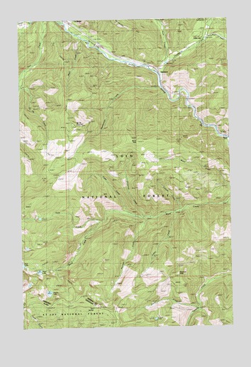
De Borgia South, MT USGS Topographic Map
Click on map above to begin viewing in our Map Viewer.

This topographic map contains these locations and features:
Feature Name Type Latitude Longitude GNIS ID View Map
Aladdin MineMineN47.2621°W115.3085°778900View Map
Armada (historical)LocaleN47.3624°W115.3288°1781690View Map
Armada School (historical)SchoolN47.3624°W115.3288°1781689View Map
Bed SpringsSpringN47.2581°W115.3334°371429View Map
Cabin CityPopulated PlaceN47.3663°W115.2643°780721View Map
Canyon CreekStreamN47.2969°W115.2810°780892View Map
Cedar CreekStreamN47.2960°W115.3126°781091View Map
Coyle CreekStreamN47.2580°W115.2713°781808View Map
De Borgia CemeteryCemeteryN47.3716°W115.3376°1781758View Map
DrexelPopulated PlaceN47.3266°W115.2526°782532View Map
Drexel (historical)LocaleN47.3266°W115.2526°1781659View Map
Drexel Post Office (historical)Post OfficeN47.3266°W115.2526°1781660View Map
Drexel School (historical)SchoolN47.3266°W115.2526°1781658View Map
East Fork Twelvemile CreekStreamN47.3672°W115.2643°782917View Map
Fisher CreekStreamN47.2966°W115.2824°783450View Map
Gold CreekStreamN47.2933°W115.3279°784043View Map
Goldberg/Tawney MineMineN47.2596°W115.3024°804715View Map
Hazel LakeLakeN47.2730°W115.3657°784681View Map
HendersonPopulated PlaceN47.3583°W115.3099°784769View Map
Henderson (historical)LocaleN47.3583°W115.2926°1781644View Map
Henderson CreekStreamN47.3474°W115.2913°784770View Map
Henderson Post Office (historical)Post OfficeN47.3583°W115.2926°1781643View Map
Henderson School (historical)SchoolN47.3583°W115.2926°1781642View Map
Interchange 22CrossingN47.3541°W115.2926°1781729View Map
Lenora LakeLakeN47.2533°W115.2966°786051View Map
Mann (historical)LocaleN47.3472°W115.2899°1781629View Map
Mayo CreekStreamN47.3674°W115.3390°786970View Map
Moon PeakSummitN47.3244°W115.3057°787609View Map
New Lanore MineMineN47.2610°W115.2982°804799View Map
New Lenore MineMineN47.2585°W115.2974°787963View Map
Newman CreekStreamN47.2947°W115.2996°787973View Map
Newman PeakSummitN47.2713°W115.2829°787974View Map
Rock CreekStreamN47.3555°W115.2879°789679View Map
Square LakeLakeN47.2643°W115.3600°791364View Map
Twelve Mile Creek BridgeBridgeN47.3672°W115.2646°1781749View Map
Twelvemile CreekStreamN47.3497°W115.2910°792487View Map
Twin CreekStreamN47.3738°W115.3518°793654View Map
Unnamed CreekStreamN47.2944°W115.3024°792597View Map
Up Up MountainSummitN47.3324°W115.3435°792600View Map
West End DivisionCivilN47.3540°W115.3023°1940738View Map
West Twin CreekStreamN47.3738°W115.3515°793136View Map

Note: Coordinates in the location and feature list above are referenced to NAD83 datum.


Copyright (C) 2008-2025 Ryan Niemi / Sunset Dynamics ... All Rights Reserved