TopoQuest Logo
Do you find TopoQuest useful?
Help keep TopoQuest running and adding new maps/features by donating!
Bitcoin:  19c7KJd3qBynnjoSw5npx9KScwjBe4ifkT
Litecoin:  LXs6TkuXGGXo1vDsWCkWVdjQX94eUKd6ui
Home View Maps Find Maps Find Places Resources & Links


De Kalb, Texas Topographic Map

USGS Map Title: De Kalb, TX
USGS Map MRC: 33094E5
DRG (GeoTIFF) Download: o33094e5.tif


Neighboring USGS Topographic Map Quads:


  De Kalb NW, TX  
33094F6
 

  Tom, OK  
33094F5
 

  Foreman, AR  
33094F4
 

  Oak Grove, TX  
33094E6
 

  De Kalb, TX  
33094E5
 

  Daniels Chapel, TX  
33094E4
 

  Hodgson, TX  
33094D6
 

  Malta, TX  
33094D5
 

  New Boston, TX  
33094D4


Map MRC Location:

N34°
W95°
N34°
W94°
H8 H7 H6 H5 H4 H3 H2 H1
G8 G7 G6 G5 G4 G3 G2 G1
F8 F7 F6 F5 F4 F3 F2 F1
E8 E7 E6 E5 E4 E3 E2 E1
D8 D7 D6 D5 D4 D3 D2 D1
C8 C7 C6 C5 C4 C3 C2 C1
B8 B7 B6 B5 B4 B3 B2 B1
A8 A7 A6 A5 A4 A3 A2 A1
N33°
W95°
N33°
W94°

De Kalb, TX USGS 1:24K Topographic Map Preview:
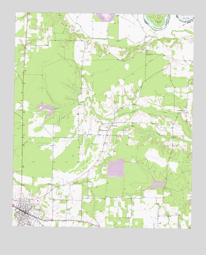
De Kalb, TX USGS Topographic Map
Click on map above to begin viewing in our Map Viewer.

This topographic map contains these locations and features:
Feature Name Type Latitude Longitude GNIS ID View Map
Anderson LakeReservoirN33.5166°W94.5012°1854960View Map
Anderson Lake DamDamN33.5168°W94.5019°1854959View Map
Bethlehem SchoolSchoolN33.5568°W94.5594°1381407View Map
Billy Hall BendBendN33.6218°W94.5249°1101286View Map
Blackman Dam Number 1DamN33.5251°W94.5185°1854961View Map
Blackman Dam Number 2DamN33.5701°W94.6002°1854963View Map
Blackman Lake Number 1ReservoirN33.5687°W94.5233°1967712View Map
Blackman Lake Number 2ReservoirN33.5687°W94.5974°1967713View Map
City of De KalbCivilN33.5075°W94.6166°2410303View Map
De KalbPopulated PlaceN33.5087°W94.6163°1381748View Map
De Kalb Police DepartmentBuildingN33.5078°W94.6165°2751212View Map
De Kalb Post OfficePost OfficeN33.5100°W94.6188°2731323View Map
Dekalb Elementary SchoolSchoolN33.5090°W94.6216°2003525View Map
Dekalb Fire DepartmentBuildingN33.5098°W94.6152°2655233View Map
Dekalb High SchoolSchoolN33.5090°W94.6216°2003526View Map
Dekalb Middle SchoolSchoolN33.5090°W94.6216°2003527View Map
Eldorado ChurchChurchN33.6021°W94.5330°1381836View Map
First Baptist ChurchChurchN33.5115°W94.6163°2016758View Map
Gunn LakeLakeN33.6169°W94.5260°1101442View Map
Harrell CemeteryCemeteryN33.5570°W94.5485°1381972View Map
Harris CemeteryCemeteryN33.5626°W94.5046°1381974View Map
Hatchel LakeReservoirN33.5697°W94.6045°1854964View Map
Liberty Hill SchoolSchoolN33.5684°W94.5077°1382147View Map
Malta Farm LakeReservoirN33.5249°W94.5190°1854962View Map
Mount Zion ChurchChurchN33.5598°W94.5572°1382357View Map
New LakeLakeN33.6218°W94.5072°1101559View Map
United Church of God in ChristChurchN33.5098°W94.6133°2016132View Map
Woodman CemeteryCemeteryN33.5073°W94.6077°1382991View Map

Note: Coordinates in the location and feature list above are referenced to NAD83 datum.


Copyright (C) 2008-2025 Ryan Niemi / Sunset Dynamics ... All Rights Reserved