TopoQuest Logo
Do you find TopoQuest useful?
Help keep TopoQuest running and adding new maps/features by donating!
Bitcoin:  19c7KJd3qBynnjoSw5npx9KScwjBe4ifkT
Litecoin:  LXs6TkuXGGXo1vDsWCkWVdjQX94eUKd6ui
Home View Maps Find Maps Find Places Resources & Links


Deadman Canyon, New Mexico Topographic Map

USGS Map Title: Deadman Canyon, NM
USGS Map MRC: 32105F8
DRG (GeoTIFF) Download: o32105f8.tif


Neighboring USGS Topographic Map Quads:


  Alamogordo South, NM  
32105G8
 

  Sacramento Peak, NM  
32105G7
 

  Tres Hermanos, NM  
32106F1
 

  Deadman Canyon, NM  
32105F8
 

  Bug Scuffle Canyon, NM  
32105F7


  Culp Canyon, NM  
32105E7


Map MRC Location:

N33°
W106°
N33°
W105°
H8 H7 H6 H5 H4 H3 H2 H1
G8 G7 G6 G5 G4 G3 G2 G1
F8 F7 F6 F5 F4 F3 F2 F1
E8 E7 E6 E5 E4 E3 E2 E1
D8 D7 D6 D5 D4 D3 D2 D1
C8 C7 C6 C5 C4 C3 C2 C1
B8 B7 B6 B5 B4 B3 B2 B1
A8 A7 A6 A5 A4 A3 A2 A1
N32°
W106°
N32°
W105°

Deadman Canyon, NM USGS 1:24K Topographic Map Preview:
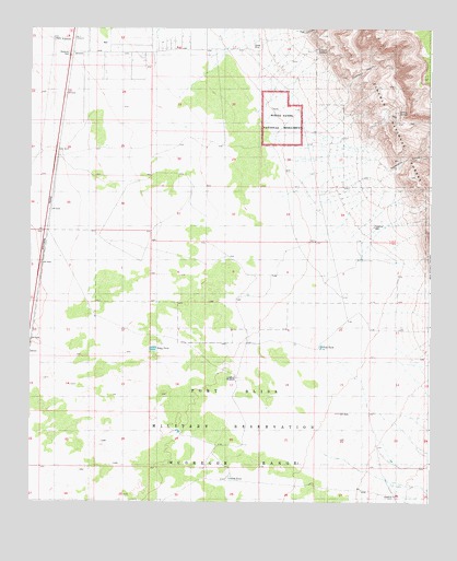
Deadman Canyon, NM USGS Topographic Map
Click on map above to begin viewing in our Map Viewer.

This topographic map contains these locations and features:
Feature Name Type Latitude Longitude GNIS ID View Map
Boles Acres Volunteer Fire Department Canyon Road StationBuildingN32.7444°W105.9571°2657976View Map
Deadman CanyonValleyN32.7368°W105.9061°905639View Map
Dog CanyonValleyN32.7481°W105.9153°905797View Map
Dog Canyon EstatesPopulated PlaceN32.7440°W105.9555°929125View Map
DunesPopulated PlaceN32.6645°W105.9989°1987911View Map
Escondido CanyonValleyN32.7137°W105.8891°906183View Map
Fairchild WellWellN32.6979°W105.8941°913292View Map
Fish TankReservoirN32.6662°W105.9089°1987907View Map
Laney SpringSpringN32.7279°W105.8852°913293View Map
Langford WindmillReservoirN32.6576°W105.9355°913291View Map
Lawson SpringSpringN32.7451°W105.9097°913294View Map
Negro Ed CanyonValleyN32.6751°W105.8922°920738View Map
Oliver Lee CampgroundLocaleN32.7451°W105.9153°924228View Map
Oliver Lee State ParkParkN32.7468°W105.9161°1987905View Map
Sacramento CityLocaleN32.6918°W105.9911°910504View Map
Sand TankReservoirN32.6312°W105.9375°1987909View Map
Tony TankReservoirN32.6654°W105.9616°913290View Map
ValmontPopulated PlaceN32.7468°W105.9875°920728View Map
Valmont Post Office (historical)Post OfficeN32.7468°W105.9875°938489View Map
White Sands National MonumentParkN32.7251°W105.9216°1987903View Map

Note: Coordinates in the location and feature list above are referenced to NAD83 datum.


Copyright (C) 2008-2025 Ryan Niemi / Sunset Dynamics ... All Rights Reserved