TopoQuest Logo
Do you find TopoQuest useful?
Help keep TopoQuest running and adding new maps/features by donating!
Bitcoin:  19c7KJd3qBynnjoSw5npx9KScwjBe4ifkT
Litecoin:  LXs6TkuXGGXo1vDsWCkWVdjQX94eUKd6ui
Home View Maps Find Maps Find Places Resources & Links


Del Norte, Colorado Topographic Map

USGS Map Title: Del Norte, CO
USGS Map MRC: 37106F3
DRG (GeoTIFF) Download: o37106f3.tif


Neighboring USGS Topographic Map Quads:


  Twin Mountains, CO  
37106G4
 

  Twin Mountains SE, CO  
37106G3
 

  La Garita, CO  
37106G2
 

  Indian Head, CO  
37106F4
 

  Del Norte, CO  
37106F3
 

  Sevenmile Plaza, CO  
37106F2
 

  Horseshoe Mountain, CO  
37106E4
 

  Dog Mountain, CO  
37106E3
 

  Monte Vista, CO  
37106E2


Map MRC Location:

N38°
W107°
N38°
W106°
H8 H7 H6 H5 H4 H3 H2 H1
G8 G7 G6 G5 G4 G3 G2 G1
F8 F7 F6 F5 F4 F3 F2 F1
E8 E7 E6 E5 E4 E3 E2 E1
D8 D7 D6 D5 D4 D3 D2 D1
C8 C7 C6 C5 C4 C3 C2 C1
B8 B7 B6 B5 B4 B3 B2 B1
A8 A7 A6 A5 A4 A3 A2 A1
N37°
W107°
N37°
W106°

Del Norte, CO USGS 1:24K Topographic Map Preview:
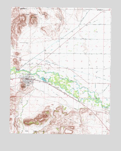
Del Norte, CO USGS Topographic Map
Click on map above to begin viewing in our Map Viewer.

This topographic map contains these locations and features:
Feature Name Type Latitude Longitude GNIS ID View Map
Astronaut Kent Rominger AirportAirportN37.7104°W106.3536°204332View Map
Catholic ChurchChurchN37.6776°W106.3565°2696364View Map
Church of Jesus Christ of Latter - day SaintsChurchN37.6718°W106.3452°2696399View Map
Del NortePopulated PlaceN37.6789°W106.3534°190305View Map
Del Norte Baptist FellowshipChurchN37.6797°W106.3529°2696365View Map
Del Norte CemeteryCemeteryN37.6878°W106.3506°190311View Map
Del Norte Community AmbulanceBuildingN37.6784°W106.3558°2716970View Map
Del Norte Emergency Medical ServicesBuildingN37.6785°W106.3452°2695550View Map
Del Norte Fire DepartmentBuildingN37.6788°W106.3508°2666898View Map
Del Norte Police DepartmentBuildingN37.6787°W106.3557°2696636View Map
Del Norte Post OfficePost OfficeN37.6779°W106.3545°2759187View Map
Del Norte Town DitchCanalN37.6767°W106.3583°2711861View Map
Dry Pole CreekStreamN37.6631°W106.3153°190315View Map
East ButteSummitN37.7397°W106.3484°190303View Map
EvansvillePopulated PlaceN37.6711°W106.3189°190308View Map
Gateway Baptist ChurchChurchN37.6781°W106.3494°2696366View Map
KGCA-AM (Del Norte)TowerN37.6894°W106.3186°203996View Map
Lookout MountainSummitN37.6711°W106.3598°190306View Map
McIntosh Arroyo DitchCanalN37.6572°W106.2857°2723529View Map
Midland CanalCanalN37.6956°W106.3314°190307View Map
New Life FellowshipChurchN37.6770°W106.3559°2696367View Map
North Channel Rio GrandeChannelN37.6769°W106.3014°190309View Map
PeņascitoSummitN37.6511°W106.2559°190316View Map
Pinos CreekStreamN37.6861°W106.3661°190302View Map
Pioneer United ChurchChurchN37.6771°W106.3531°2696368View Map
Raber DitchCanalN37.6695°W106.2872°2724157View Map
Rio Grande County JailBuildingN37.6766°W106.3504°2757346View Map
Rio Grande County Sanitary LandfillSlopeN37.7158°W106.3500°197160View Map
Rio Grande Ditch 2CanalN37.6884°W106.3341°2724181View Map
Rio Grande HospitalHospitalN37.6743°W106.3638°2695600View Map
Rio Grande Number 1CanalN37.6561°W106.3039°190314View Map
Rio Grande Sheriff's OfficeBuildingN37.6765°W106.3505°2696603View Map
Rio Granite Granite QuarryMineN37.6803°W106.3500°1735058View Map
San Francisco CreekStreamN37.6697°W106.3439°190312View Map
Silva DitchCanalN37.6501°W106.2518°2724262View Map
Spiegel MineMineN37.6786°W106.3545°1735059View Map
Spring BranchStreamN37.6456°W106.3603°190313View Map
Town of Del NorteCivilN37.6784°W106.3539°2412416View Map
Valdeses CemeteryCemeteryN37.6475°W106.2536°190317View Map

Note: Coordinates in the location and feature list above are referenced to NAD83 datum.


Copyright (C) 2008-2024 Ryan Niemi / Sunset Dynamics ... All Rights Reserved