TopoQuest Logo
Do you find TopoQuest useful?
Help keep TopoQuest running and adding new maps/features by donating!
Bitcoin:  19c7KJd3qBynnjoSw5npx9KScwjBe4ifkT
Litecoin:  LXs6TkuXGGXo1vDsWCkWVdjQX94eUKd6ui
Home View Maps Find Maps Find Places Resources & Links


Del Rio SW, Texas Topographic Map

USGS Map Title: Del Rio SW, TX
USGS Map MRC: 29100C8
DRG (GeoTIFF) Download: o29100c8.tif


Neighboring USGS Topographic Map Quads:


  Amistad Dam, TX  
29101D1
 

  Del Rio NW, TX  
29100D8
 

  Del Rio NE, TX  
29100D7


  Del Rio SW, TX  
29100C8
 

  Del Rio SE, TX  
29100C7


  Maverick Dam, TX  
29100B7


Map MRC Location:

N30°
W101°
N30°
W100°
H8 H7 H6 H5 H4 H3 H2 H1
G8 G7 G6 G5 G4 G3 G2 G1
F8 F7 F6 F5 F4 F3 F2 F1
E8 E7 E6 E5 E4 E3 E2 E1
D8 D7 D6 D5 D4 D3 D2 D1
C8 C7 C6 C5 C4 C3 C2 C1
B8 B7 B6 B5 B4 B3 B2 B1
A8 A7 A6 A5 A4 A3 A2 A1
N29°
W101°
N29°
W100°

Del Rio SW, TX USGS 1:24K Topographic Map Preview:
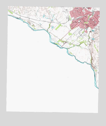
Del Rio SW, TX USGS Topographic Map
Click on map above to begin viewing in our Map Viewer.

This topographic map contains these locations and features:
Feature Name Type Latitude Longitude GNIS ID View Map
Austin Elementary SchoolSchoolN29.3544°W100.8926°2009058View Map
Calaveras CreekStreamN29.3472°W100.8870°1331862View Map
Cassinelli Gin HouseBuildingN29.3536°W100.8968°2031405View Map
Central Church of the NazareneChurchN29.3588°W100.8812°2024358View Map
Cienegas CreekStreamN29.3455°W100.9451°1373113View Map
Cienegas TerracePopulated PlaceN29.3675°W100.9437°1852693View Map
Cienegas Terrace Census Designated PlaceCensusN29.3688°W100.9432°2407621View Map
Cienegas Terrace ColoniaPopulated PlaceN29.3683°W100.9504°2010769View Map
City of Del RioCivilN29.3706°W100.8799°2410316View Map
Del RioPopulated PlaceN29.3627°W100.8968°1334233View Map
Del Rio City HallBuildingN29.3610°W100.9004°2753510View Map
Del Rio Fire and Rescue Station 1BuildingN29.3597°W100.8950°2552108View Map
Del Rio Fire and Rescue Station 4BuildingN29.3707°W100.9186°2551354View Map
Del Rio International AirportAirportN29.3706°W100.9202°1386539View Map
Del Rio Post Office Pecan StationPost OfficeN29.3623°W100.8991°2731339View Map
East Side Elementary SchoolSchoolN29.3750°W100.8976°2009009View Map
Fermin Calderon Elementary SchoolSchoolN29.3731°W100.8765°2009010View Map
First Presbyterian ChurchChurchN29.3608°W100.8965°2024361View Map
Greenwood SchoolSchoolN29.3572°W100.9029°1337000View Map
Guadalupe SchoolSchoolN29.3538°W100.8898°1337068View Map
Iglesia Bautista Nueva Vida ChurchChurchN29.3672°W100.8973°2024354View Map
Iglesia Luterana Cristo el Salvador ChurchChurchN29.3591°W100.9101°2024360View Map
International BridgeBridgeN29.3269°W100.9273°1374226View Map
Lamar Elementary SchoolSchoolN29.3619°W100.8851°2009012View Map
Lamar Elementary SchoolSchoolN29.3608°W100.8846°1340776View Map
Moore ParkParkN29.3680°W100.8840°1341874View Map
North Heights Elementary SchoolSchoolN29.3733°W100.9051°2009014View Map
Old San Felipe CemeteryCemeteryN29.3447°W100.8826°1343222View Map
Owens Addition Number 1 ColoniaPopulated PlaceN29.3652°W100.9293°2010773View Map
Owens Addition Number 2 ColoniaPopulated PlaceN29.3672°W100.9284°2010774View Map
Payment ColoniaPopulated PlaceN29.3641°W100.9315°2010775View Map
Primera Iglesia Bautista ChurchChurchN29.3616°W100.8848°2024356View Map
Rio Bravo ColoniaPopulated PlaceN29.3322°W100.9143°2010776View Map
Roosevelt ParkParkN29.3658°W100.8906°1345539View Map
Round MountainSummitN29.3463°W100.8868°1345671View Map
Sacred Heart Catholic SchoolSchoolN29.3583°W100.8967°1345813View Map
Saint Joseph SchoolSchoolN29.3575°W100.9068°1345972View Map
Salt CreekStreamN29.3486°W100.9512°1375933View Map
Sam Houston KindergartenSchoolN29.3550°W100.8829°2008966View Map
Sam Houston SchoolSchoolN29.3550°W100.8829°1346273View Map
San Felipe CemeteryCemeteryN29.3491°W100.8804°1346330View Map
San Felipe Country ClubLocaleN29.3711°W100.8818°1384477View Map
San Felipe CreekStreamN29.3263°W100.9193°1346331View Map
San Felipe Memorial Middle SchoolSchoolN29.3580°W100.8817°1346334View Map
San Felipe Middle SchoolSchoolN29.3588°W100.8818°2008967View Map
San Felipe SpringsSpringN29.3733°W100.8829°1346336View Map
Segunda Iglesia Bautista ChurchChurchN29.3580°W100.8865°2024357View Map
Seventh Day Adventist ChurchChurchN29.3691°W100.9043°2024363View Map
Star ParkParkN29.3688°W100.9029°1347814View Map
Stephen SchoolSchoolN29.3550°W100.8920°1347885View Map
Travis Elementary SchoolSchoolN29.3658°W100.8784°2008968View Map
Travis SchoolSchoolN29.3655°W100.8773°1348719View Map
Uco ParkParkN29.3563°W100.9151°2030064View Map
Val Verde County Constable's OfficeBuildingN29.3591°W100.8972°2750717View Map
Val Verde County CourthouseBuildingN29.3591°W100.8970°2032500View Map
Val Verde County JailBuildingN29.3591°W100.8970°2033636View Map
Val Verde County Rural Volunteer Fire Department Station 1BuildingN29.3569°W100.9212°2551272View Map
Westlawn CemeteryCemeteryN29.3625°W100.9193°1349865View Map
Whitehead Memorial MuseumBuildingN29.3522°W100.8981°2014414View Map

Note: Coordinates in the location and feature list above are referenced to NAD83 datum.


Copyright (C) 2008-2024 Ryan Niemi / Sunset Dynamics ... All Rights Reserved