TopoQuest Logo
Do you find TopoQuest useful?
Help keep TopoQuest running and adding new maps/features by donating!
Bitcoin:  19c7KJd3qBynnjoSw5npx9KScwjBe4ifkT
Litecoin:  LXs6TkuXGGXo1vDsWCkWVdjQX94eUKd6ui
Home View Maps Find Maps Find Places Resources & Links


Devils Lake, North Dakota Topographic Map

USGS Map Title: Devils Lake, ND
USGS Map MRC: 48098A7
DRG (GeoTIFF) Download: o48098a7.tif


Neighboring USGS Topographic Map Quads:


  Grand Harbor, ND  
48098B8
 

  Sweetwater, ND  
48098B7
 

  Crary NW, ND  
48098B6
 

  Camp Grafton, ND  
48098A8
 

  Devils Lake, ND  
48098A7
 

  Crary, ND  
48098A6
 

  Fort Totten, ND  
47098H8
 

  Tokio, ND  
47098H7
 

  Free Peoples Lake, ND  
47098H6


Map MRC Location:

N49°
W99°
N49°
W98°
H8 H7 H6 H5 H4 H3 H2 H1
G8 G7 G6 G5 G4 G3 G2 G1
F8 F7 F6 F5 F4 F3 F2 F1
E8 E7 E6 E5 E4 E3 E2 E1
D8 D7 D6 D5 D4 D3 D2 D1
C8 C7 C6 C5 C4 C3 C2 C1
B8 B7 B6 B5 B4 B3 B2 B1
A8 A7 A6 A5 A4 A3 A2 A1
N48°
W99°
N48°
W98°

Devils Lake, ND USGS 1:24K Topographic Map Preview:
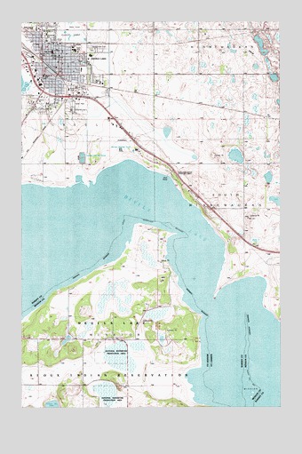
Devils Lake, ND USGS Topographic Map
Click on map above to begin viewing in our Map Viewer.

This topographic map contains these locations and features:
Feature Name Type Latitude Longitude GNIS ID View Map
Central Middle SchoolSchoolN48.1150°W98.8604°2747666View Map
Devils Lake City Fire StationBuildingN48.1146°W98.8658°2637641View Map
Devils Lake City HallBuildingN48.1140°W98.8591°2744108View Map
Devils Lake Police DepartmentBuildingN48.1073°W98.8663°2734453View Map
Devils Lake Post OfficePost OfficeN48.1103°W98.8584°2741967View Map
Devils Lake Rural Fire DepartmentBuildingN48.0992°W98.8664°2637534View Map
Good Samaritan Society-Devils LakeBuildingN48.1109°W98.8556°2748693View Map
Grand Army of the Republic CemeteryCemeteryN48.1158°W98.8407°1029069View Map
Heartland Care CenterBuildingN48.1140°W98.8420°2748695View Map
KDLR-AM (Devils Lake)TowerN48.1117°W98.8457°1033435View Map
KDVL-FM (Devils Lake)TowerN48.1117°W98.8457°1033049View Map
KeithPopulated PlaceN48.0933°W98.7526°1033767View Map
Lake Region Ambulance ServiceBuildingN48.1122°W98.8631°2658786View Map
Lake Region Heritage CenterBuildingN48.1115°W98.8586°2748908View Map
Lake Region Public LibraryBuildingN48.1151°W98.8593°2745435View Map
Lincoln SchoolSchoolN48.1214°W98.8662°1029899View Map
Mercy HospitalHospitalN48.1158°W98.8505°2733258View Map
Minnie H Elementary SchoolSchoolN48.1075°W98.8646°2747663View Map
North Dakota Highway Patrol Devils LakeBuildingN48.1071°W98.8680°2734447View Map
North Dakota Maritime MuseumBuildingN48.1131°W98.8594°2748909View Map
North Dakota School for the DeafSchoolN48.1229°W98.8669°2747670View Map
Prairie View Elementary SchoolSchoolN48.1095°W98.8465°2747664View Map
Ramsey County CourthouseBuildingN48.1136°W98.8598°2743511View Map
Ramsey County JailBuildingN48.1073°W98.8666°2734489View Map
Ramsey County Sheriff's OfficeBuildingN48.1073°W98.8669°2734347View Map
Roosevelt ParkParkN48.1125°W98.8710°1030964View Map
Saint Joseph Elementary SchoolSchoolN48.1167°W98.8507°2747668View Map
Saint Joseph's Catholic CemeteryCemeteryN48.1156°W98.8393°2782513View Map
Saint Marys AcademySchoolN48.1153°W98.8482°1031212View Map
School Number 1SchoolN48.0075°W98.8246°1031502View Map
School Number 3SchoolN48.0800°W98.7668°1031864View Map
Sheriff's MusuemBuildingN48.1136°W98.8594°2748910View Map
Sweetwater Elementary SchoolSchoolN48.1209°W98.8633°2747665View Map
Washington SchoolSchoolN48.1117°W98.8548°1032697View Map

Note: Coordinates in the location and feature list above are referenced to NAD83 datum.


Copyright (C) 2008-2025 Ryan Niemi / Sunset Dynamics ... All Rights Reserved