TopoQuest Logo
Do you find TopoQuest useful?
Help keep TopoQuest running and adding new maps/features by donating!
Bitcoin:  19c7KJd3qBynnjoSw5npx9KScwjBe4ifkT
Litecoin:  LXs6TkuXGGXo1vDsWCkWVdjQX94eUKd6ui
Home View Maps Find Maps Find Places Resources & Links


Dillon West, South Carolina Topographic Map

USGS Map Title: Dillon West, SC
USGS Map MRC: 34079D4
DRG (GeoTIFF) Download: o34079d4.tif


Neighboring USGS Topographic Map Quads:


  Clio, SC  
34079E5
 

  Minturn, SC  
34079E4
 

  Rowland, NC  
34079E3
 

  Bingham, SC  
34079D5
 

  Dillon West, SC  
34079D4
 

  Dillon East, SC  
34079D3
 

  Oak Grove, SC  
34079C5
 

  Latta, SC  
34079C4
 

  Fork, SC  
34079C3


Map MRC Location:

N35°
W80°
N35°
W79°
H8 H7 H6 H5 H4 H3 H2 H1
G8 G7 G6 G5 G4 G3 G2 G1
F8 F7 F6 F5 F4 F3 F2 F1
E8 E7 E6 E5 E4 E3 E2 E1
D8 D7 D6 D5 D4 D3 D2 D1
C8 C7 C6 C5 C4 C3 C2 C1
B8 B7 B6 B5 B4 B3 B2 B1
A8 A7 A6 A5 A4 A3 A2 A1
N34°
W80°
N34°
W79°

Dillon West, SC USGS 1:24K Topographic Map Preview:
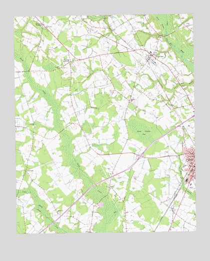
Dillon West, SC USGS Topographic Map
Click on map above to begin viewing in our Map Viewer.

This topographic map contains these locations and features:
Feature Name Type Latitude Longitude GNIS ID View Map
Alford CemeteryCemeteryN34.4818°W79.4823°1220156View Map
Betheas Chapel Church (historical)ChurchN34.4141°W79.4303°1236077View Map
Betheas Chapel School (historical)SchoolN34.4154°W79.4298°1236078View Map
Betsy Jackson BaySwampN34.4330°W79.4122°1245686View Map
Beulah Baptist Church CemeteryCemeteryN34.4935°W79.3775°1964692View Map
Beulah ChurchChurchN34.4935°W79.3767°1246857View Map
Bowling Green ChurchChurchN34.4466°W79.4420°1246953View Map
Bunker HillPopulated PlaceN34.4507°W79.4195°1221124View Map
C and M Hog FarmLocaleN34.4583°W79.4889°2635237View Map
CentervillePopulated PlaceN34.4115°W79.4923°1227882View Map
Dickinson Church (historical)ChurchN34.3843°W79.4945°1236087View Map
Dillon Bi-Lo Plaza Shopping CenterLocaleN34.4021°W79.3781°1236088View Map
Dillon City Fire DepartmentBuildingN34.4273°W79.3816°2368384View Map
Dillon CountyCivilN34.3916°W79.3789°1247993View Map
Dillon County CourthouseBuildingN34.4182°W79.3753°1236090View Map
Dillon County Development BoardBuildingN34.4179°W79.3768°2490458View Map
Dillon County Disaster Preparedness AgencyBuildingN34.4127°W79.3776°2334911View Map
Dillon County Fire Department Station 1BuildingN34.4126°W79.3780°2368290View Map
Dillon County Sheriff's OfficeBuildingN34.4175°W79.3758°2334840View Map
Dillon DivisionCivilN34.4365°W79.4322°1938248View Map
Dillon Police DepartmentBuildingN34.4188°W79.3765°2334876View Map
DothanPopulated PlaceN34.4010°W79.4334°1236093View Map
Dothan Baptist ChurchChurchN34.3999°W79.4342°1236094View Map
Dothan ChurchChurchN34.4007°W79.4342°1247545View Map
Dothan Methodist Church CemeteryCemeteryN34.4007°W79.4342°1964695View Map
Dothan School (historical)SchoolN34.4002°W79.4339°1236095View Map
Eli BranchStreamN34.4471°W79.4712°1222258View Map
Fellowship Baptist ChurchChurchN34.4271°W79.3825°1236102View Map
GalavonPopulated PlaceN34.4974°W79.4520°1227904View Map
Hamers BridgeBridgeN34.4877°W79.3950°1236114View Map
Hamilton CemeteryCemeteryN34.4349°W79.3834°1222995View Map
Holiness Church (historical)ChurchN34.4529°W79.4245°1236120View Map
Interchange 190CrossingN34.4188°W79.4123°1228332View Map
Little RockPopulated PlaceN34.4766°W79.4031°1246427View Map
Little Rock CemeteryCemeteryN34.4765°W79.4056°1236141View Map
Little Rock Post OfficePost OfficeN34.4743°W79.4060°2489853View Map
Little Rock School (historical)SchoolN34.4785°W79.4048°1236142View Map
Manning CrossroadsPopulated PlaceN34.4735°W79.4603°1246522View Map
Martin Junior High School Maple CampusSchoolN34.4124°W79.3823°1246531View Map
McCormick CrossroadsPopulated PlaceN34.4954°W79.4792°1246584View Map
Mount Hermon Church of godChurchN34.4160°W79.3806°1236157View Map
Mount Holly CemeteryCemeteryN34.4049°W79.3820°1224714View Map
New Holly Church (historical)ChurchN34.4252°W79.4795°1236159View Map
New Holly School (historical)SchoolN34.4232°W79.4781°1236160View Map
Old Mill CreekStreamN34.3802°W79.4376°1225200View Map
Pine Hill ChurchChurchN34.4377°W79.4859°1250115View Map
Pine Hill School (historical)SchoolN34.4382°W79.4859°1236173View Map
Pleasant Hill ChurchChurchN34.3874°W79.4712°1250169View Map
Pleasant Hill School (historical)SchoolN34.3868°W79.4709°1236174View Map
Price AirportAirportN34.4737°W79.3945°2650841View Map
Ramsey CemeteryCemeteryN34.4696°W79.4689°1225745View Map
Reedy Creek ChurchChurchN34.4935°W79.4773°1250324View Map
Reedy Creek Church CemeteryCemeteryN34.4938°W79.4784°1964705View Map
Reedy Creek School (historical)SchoolN34.4929°W79.4775°1236176View Map
Reedy Creek Volunteer Fire DepartmentBuildingN34.4943°W79.4789°2578573View Map
Rogers CemeteryCemeteryN34.4115°W79.4337°1225995View Map
Ropers CemeteryCemeteryN34.4585°W79.3834°1226009View Map
Stewart Heights Elementary SchoolSchoolN34.4252°W79.3845°1236187View Map
Sweat SwampStreamN34.4924°W79.3934°1251086View Map

Note: Coordinates in the location and feature list above are referenced to NAD83 datum.


Copyright (C) 2008-2024 Ryan Niemi / Sunset Dynamics ... All Rights Reserved