TopoQuest Logo
Do you find TopoQuest useful?
Help keep TopoQuest running and adding new maps/features by donating!
Bitcoin:  19c7KJd3qBynnjoSw5npx9KScwjBe4ifkT
Litecoin:  LXs6TkuXGGXo1vDsWCkWVdjQX94eUKd6ui
Home View Maps Find Maps Find Places Resources & Links


Dillonvale, Ohio Topographic Map

USGS Map Title: Dillonvale, OH
USGS Map MRC: 40080B7
DRG (GeoTIFF) Download: o40080b7.tif


Neighboring USGS Topographic Map Quads:


  Cadiz, OH  
40080C8
 

  Smithfield, OH  
40080C7
 

  Steubenville West, OH  
40080C6
 

  Harrisville, OH  
40080B8
 

  Dillonvale, OH  
40080B7
 

  Tiltonsville, OH  
40080B6
 

  Saint Clairsville, OH  
40080A8
 

  Lansing, OH  
40080A7
 

  Wheeling, WV  
40080A6


Map MRC Location:

N41°
W81°
N41°
W80°
H8 H7 H6 H5 H4 H3 H2 H1
G8 G7 G6 G5 G4 G3 G2 G1
F8 F7 F6 F5 F4 F3 F2 F1
E8 E7 E6 E5 E4 E3 E2 E1
D8 D7 D6 D5 D4 D3 D2 D1
C8 C7 C6 C5 C4 C3 C2 C1
B8 B7 B6 B5 B4 B3 B2 B1
A8 A7 A6 A5 A4 A3 A2 A1
N40°
W81°
N40°
W80°

Dillonvale, OH USGS 1:24K Topographic Map Preview:
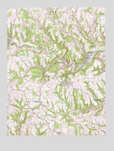
Dillonvale, OH USGS Topographic Map
Click on map above to begin viewing in our Map Viewer.

This topographic map contains these locations and features:
Feature Name Type Latitude Longitude GNIS ID View Map
AdenaPopulated PlaceN40.2187°W80.8729°1037321View Map
Adena Elementary SchoolSchoolN40.2228°W80.8709°1051092View Map
Adena Presbyterian CemeteryCemeteryN40.2162°W80.8743°1961677View Map
Adena Presbyterian ChurchChurchN40.2165°W80.8743°1961678View Map
Adena Volunteer Fire CompanyBuildingN40.2160°W80.8694°2549939View Map
Blue RidgeRidgeN40.2370°W80.7929°1038133View Map
BradleyPopulated PlaceN40.2470°W80.7756°1048540View Map
Brier RidgeRidgeN40.2184°W80.8009°1038307View Map
Cabbage RunStreamN40.2434°W80.8134°1060915View Map
Central Elementary SchoolSchoolN40.1951°W80.7759°1051098View Map
Cherry RidgeRidgeN40.2367°W80.8604°1039017View Map
Coal RunStreamN40.1487°W80.7934°1065741View Map
ColerainPopulated PlaceN40.1259°W80.8087°1056823View Map
Colerain Post OfficePost OfficeN40.1265°W80.8081°1959449View Map
Crow HollowValleyN40.2209°W80.7684°1039501View Map
DeyarmonvillePopulated PlaceN40.2117°W80.7615°1064538View Map
DillonvalePopulated PlaceN40.1965°W80.7751°1064542View Map
Dillonvale Emergency Medical ServicesBuildingN40.1958°W80.7746°2550781View Map
Dillonvale Police DepartmentBuildingN40.1953°W80.7758°2732809View Map
Dillonvale Post OfficePost OfficeN40.1959°W80.7748°2015483View Map
Dillonvale Volunteer Fire DepartmentBuildingN40.1956°W80.7748°2549936View Map
Dorothy Mine PondReservoirN40.1613°W80.7625°1077826View Map
Dorothy Mine Pond DamDamN40.1601°W80.7615°1077825View Map
Dry ForkStreamN40.2101°W80.7581°1061023View Map
DunglenPopulated PlaceN40.1953°W80.7995°1062738View Map
Dunglen Mine ImpoundmentReservoirN40.1912°W80.8091°1077828View Map
Dunglen Mine Impoundment DamDamN40.1917°W80.8081°1077827View Map
Dunglen Post OfficePost OfficeN40.1959°W80.7998°2015484View Map
EmersonPopulated PlaceN40.1776°W80.8229°1064620View Map
Emerson Post Office (historical)Post OfficeN40.1778°W80.8229°2015486View Map
Goose RunStreamN40.2137°W80.8484°1040965View Map
Grape RidgeRidgeN40.2337°W80.8406°1041054View Map
Grays RidgeRidgeN40.1398°W80.8731°1041091View Map
HerrickPopulated PlaceN40.2098°W80.8306°1062812View Map
Herrick Post Office (historical)Post OfficeN40.2098°W80.8304°2015494View Map
Hicksite CemeteryCemeteryN40.1760°W80.8293°1041533View Map
Highland CemeteryCemeteryN40.1801°W80.7965°1041552View Map
Hilltop Elementary SchoolSchoolN40.1370°W80.8226°1050391View Map
Holmes CemeteryCemeteryN40.2184°W80.8526°1041676View Map
Irish RidgeRidgeN40.1628°W80.7943°1066365View Map
Jug RunStreamN40.2073°W80.7506°1042156View Map
Long RunStreamN40.1998°W80.8095°1042759View Map
Long RunPopulated PlaceN40.1951°W80.8156°1048932View Map
Morning View Post Office (historical)Post OfficeN40.1390°W80.7943°1959432View Map
MorningviewPopulated PlaceN40.1387°W80.7940°1065057View Map
Mount PleasantPopulated PlaceN40.1753°W80.7979°1048993View Map
Mount Pleasant Police DepartmentBuildingN40.1750°W80.8002°2732472View Map
Mount Pleasant Post OfficePost OfficeN40.1751°W80.7984°2015503View Map
Mount Pleasant Volunteer Fire DepartmentBuildingN40.1785°W80.8024°2549933View Map
North Fork Short CreekStreamN40.2203°W80.8734°1043945View Map
Oak Grove CemeteryCemeteryN40.1770°W80.7654°1960356View Map
Oak Grove CemeteryCemeteryN40.1770°W80.7655°1044031View Map
Olszeski TownPopulated PlaceN40.1945°W80.7887°1057900View Map
Parkers RunStreamN40.1556°W80.7542°1044304View Map
Perrin RunStreamN40.2126°W80.8104°1066889View Map
Pine ValleyPopulated PlaceN40.2042°W80.7673°1044474View Map
Pine Valley Post Office (historical)Post OfficeN40.2042°W80.7679°2015511View Map
Piney ForkStreamN40.2078°W80.7604°1057923View Map
Piney Fork Prep Plant Slurry PondReservoirN40.2417°W80.8265°1077829View Map
Pleasant GrovePopulated PlaceN40.1503°W80.8423°1065535View Map
Pleasant Grove CemeteryCemeteryN40.1509°W80.8462°1699403View Map
Pleasant Grove Post Office (historical)Post OfficeN40.1501°W80.8429°1959430View Map
RamseyPopulated PlaceN40.1928°W80.8334°1057944View Map
Ramsey Post Office (historical)Post OfficeN40.1931°W80.8331°2015514View Map
Rehoboth CemeteryCemeteryN40.2337°W80.8593°1044931View Map
Saint Adelbert CemeteryCemeteryN40.2034°W80.7517°1045349View Map
Saint Casimirs CemeteryCemeteryN40.2131°W80.8509°1045328View Map
Scotch RidgeRidgeN40.1442°W80.7706°1046045View Map
Scotch Ridge CemeteryCemeteryN40.1298°W80.7609°1700885View Map
Scotch Ridge ChurchChurchN40.1303°W80.7606°1046046View Map
Seceder CemeteryCemeteryN40.1751°W80.7934°1046077View Map
Startle (historical)Populated PlaceN40.1940°W80.8193°1077616View Map
Startle Post Office (historical)Post OfficeN40.1945°W80.8193°2015522View Map
Township of Mount PleasantCivilN40.1797°W80.8232°1086380View Map
Township of SmithfieldCivilN40.2461°W80.8195°1086384View Map
Trenton ChurchChurchN40.1790°W80.8209°1047137View Map
Village of DillonvaleCivilN40.1985°W80.7757°2398726View Map
Village of Mount PleasantCivilN40.1759°W80.7997°2399415View Map
Village of Mount Pleasant Historic DistrictParkN40.1756°W80.7990°1069165View Map
Warren RidgeRidgeN40.2320°W80.7579°1047574View Map
Wheeler CemeteryCemeteryN40.2453°W80.7995°1047845View Map

Note: Coordinates in the location and feature list above are referenced to NAD83 datum.


Copyright (C) 2008-2024 Ryan Niemi / Sunset Dynamics ... All Rights Reserved