TopoQuest Logo
Do you find TopoQuest useful?
Help keep TopoQuest running and adding new maps/features by donating!
Bitcoin:  19c7KJd3qBynnjoSw5npx9KScwjBe4ifkT
Litecoin:  LXs6TkuXGGXo1vDsWCkWVdjQX94eUKd6ui
Home View Maps Find Maps Find Places Resources & Links


Dimmitt, Texas Topographic Map

USGS Map Title: Dimmitt, TX
USGS Map MRC: 34102E3
DRG (GeoTIFF) Download: o34102e3.tif


Neighboring USGS Topographic Map Quads:


  Easter, TX  
34102F4
 

  Jumbo, TX  
34102F3
 

  Nazareth NW, TX  
34102F2
 

  Dimmitt SW, TX  
34102E4
 

  Dimmitt, TX  
34102E3
 

  Nazareth SW, TX  
34102E2
 

  Flagg, TX  
34102D4
 

  Dodd NE, TX  
34102D3
 

  Hart NW, TX  
34102D2


Map MRC Location:

N35°
W103°
N35°
W102°
H8 H7 H6 H5 H4 H3 H2 H1
G8 G7 G6 G5 G4 G3 G2 G1
F8 F7 F6 F5 F4 F3 F2 F1
E8 E7 E6 E5 E4 E3 E2 E1
D8 D7 D6 D5 D4 D3 D2 D1
C8 C7 C6 C5 C4 C3 C2 C1
B8 B7 B6 B5 B4 B3 B2 B1
A8 A7 A6 A5 A4 A3 A2 A1
N34°
W103°
N34°
W102°

Dimmitt, TX USGS 1:24K Topographic Map Preview:
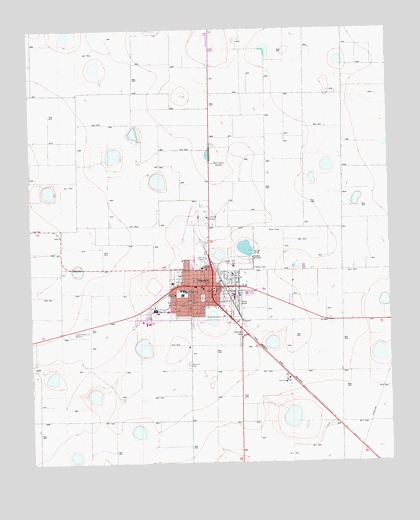
Dimmitt, TX USGS Topographic Map
Click on map above to begin viewing in our Map Viewer.

This topographic map contains these locations and features:
Feature Name Type Latitude Longitude GNIS ID View Map
Castro CountyCivilN34.5300°W102.2617°1383820View Map
Castro County Constable's OfficeBuildingN34.5504°W102.3117°2750668View Map
Castro County CourthouseBuildingN34.5509°W102.3124°2030611View Map
Castro County JailBuildingN34.5501°W102.3118°2738804View Map
Castro County Sheriff's OfficeBuildingN34.5503°W102.3118°2750372View Map
Castro Memorial GardensCemeteryN34.5282°W102.3208°1356030View Map
City of DimmittCivilN34.5488°W102.3191°2410341View Map
Dimmit City OfficesBuildingN34.5495°W102.3108°2753137View Map
DimmittPopulated PlaceN34.5509°W102.3119°1356029View Map
Dimmitt Alternative CenterSchoolN34.5495°W102.3144°2003372View Map
Dimmitt Fire DepartmentBuildingN34.5507°W102.3187°2551982View Map
Dimmitt Middle SchoolSchoolN34.5441°W102.3327°2003374View Map
Dimmitt Municipal AirportAirportN34.5691°W102.3189°1386558View Map
Dimmitt Police DepartmentBuildingN34.5496°W102.3107°2750336View Map
Dimmitt Post OfficePost OfficeN34.5491°W102.3108°2732265View Map
Emanuel Baptist ChurchChurchN34.5462°W102.3099°2016650View Map
First Baptist ChurchChurchN34.5465°W102.3196°2016651View Map
KDHN-AM (Dimmitt)TowerN34.5865°W102.3102°1385547View Map
KDIU-FM (Dimmitt)TowerN34.5865°W102.3102°1385842View Map
Lee Street Baptist ChurchChurchN34.5473°W102.3135°2016652View Map
New Hope Baptist ChurchChurchN34.5528°W102.3044°2016653View Map
Plains Memorial HospitalHospitalN34.5561°W102.3160°2015645View Map
Presbyterian ChurchChurchN34.5442°W102.3316°2016654View Map
Richardson Elementary SchoolSchoolN34.5484°W102.3228°2003379View Map
West Lawn Memorial ParkCemeteryN34.5374°W102.3617°1353947View Map

Note: Coordinates in the location and feature list above are referenced to NAD83 datum.


Copyright (C) 2008-2025 Ryan Niemi / Sunset Dynamics ... All Rights Reserved